Start

Quickstart

A quick introduction to the standard screen, tools, layers, maps, objects, search and live features.

Interface

Standard View

The standard screen is the map as your workspace. Numbered markers sit next to the visible controls; the legend explains the areas. Only Details links open additional manual pages.
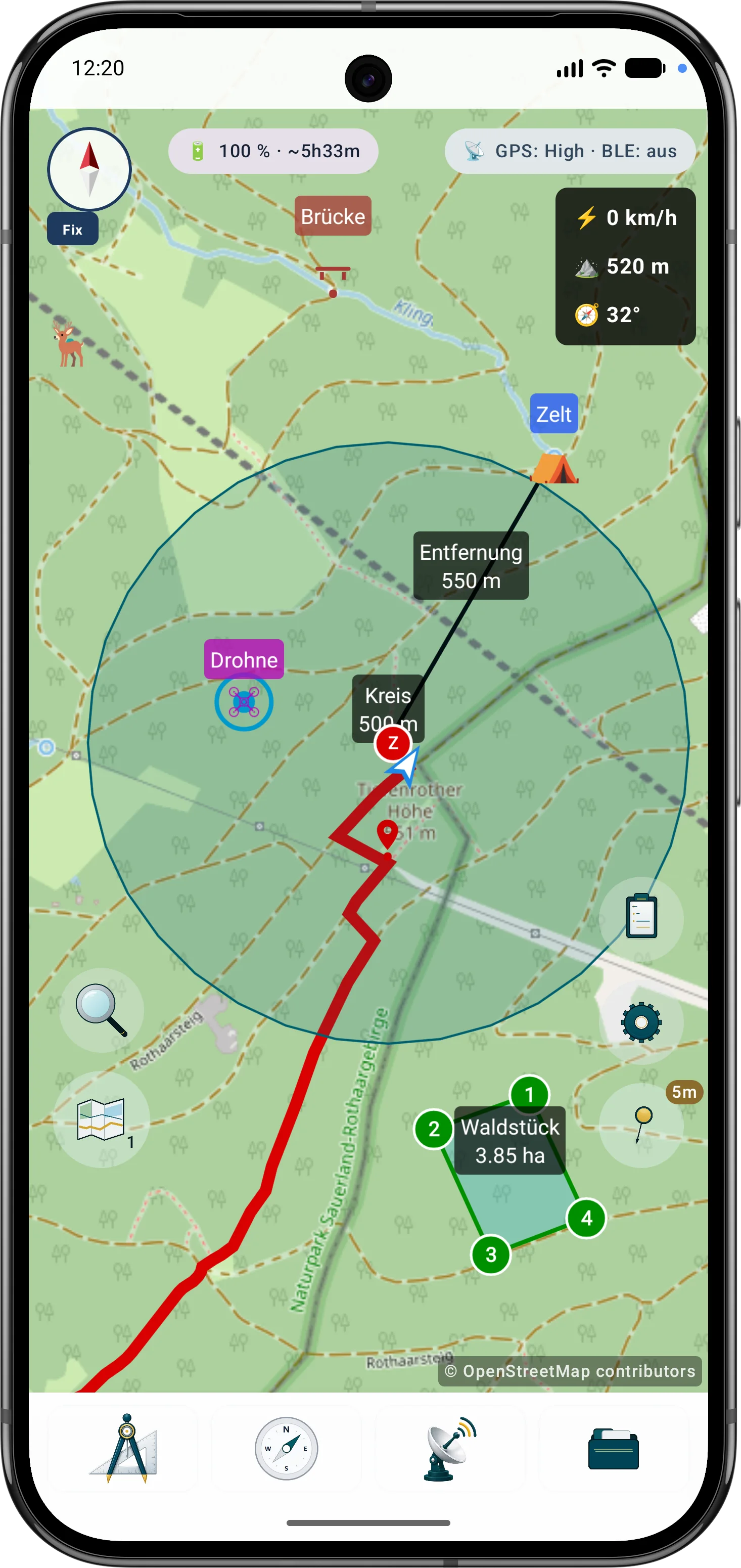
ArxSilex MapTools standard view with map, compass, telemetry display, status indicators and control buttons
The numbers mark the areas in the image; Details links open the related manual pages.
1 🧭 Compass & FixMap orientation and fixed bearing direction. Tap: Fix toggles the fixed bearing on or off.
Long press: opens the compass view.
Double tap: aligns the map to north.
Details
2 🔋 EnergyShows battery level, estimated runtime and GPS/battery strategy hints. Opens GPS, battery and GNSS details.
3 📡 GPS/BLEShows GPS accuracy, radio status and active live functions such as tracking, groups, drones, navigation or search grid. Opens status details.
4 📊 Telemetry displayShows speed, altitude and heading angle directly on the map while you are working.
5 📍 Own positionMarks your current GPS position and viewing direction on the map.
6 🔍 SearchSearch combines coordinate input and POI search. Project objects are available in the object browser. Tap: opens coordinate input.
Long press: opens POI search.
7 🗺️ LayersManages map slots, the active map, layers and overlays. Tap: switches to the next active map slot.
Long press: opens the map browser.
8 📋 Object browserHere you find markers, waypoints, tracks, routes, areas, circles, distances, bearings, viewranges and search grids. You can search, filter, show or hide items, create collections, open details, edit, copy, move, export or delete objects.
9 ⚙️ SettingsHere you control profiles, appearance, language, units, coordinate format, GPS, compass, maps, layers, terrain, POI and operation options.
10 📍 GPS & map infoCenters the map on your position and shows the current accuracy. Tap: jumps to the GPS position and toggles automatic centering.
Long press: enables or exits map info mode.
11 🛠️ ToolsHere you find tools for Marker, Distance, Bearing, Area, Circle, Visible area. More details
12 🧭 NavigateEverything around navigation: Target, Tracking, Route, Follow route, AR Mode. More details
13 📡 LiveHere you find live functions for Drones, Search Grid, Groups. More details
14 📂 DataHere you find Data Center, Projects, Undo. In the Data Center you manage Projects and exchange, Load and Import, Export and Share, Create app backup, Restore app backup, Resources. More details

Screen Areas

What You See on the Standard Screen

The key controls are available directly from the map view.

Tools

The toolbar starts map actions directly on the workspace.

  • Add markers and document points
  • Create distances, bearings, areas and circles
  • Set route points and calculate viewranges
  • Cancel active tools or undo inputs step by step

Settings

The settings menu groups behavior, display and working profiles.

  • Choose app mode, language, theme and coordinate format
  • Adjust map profiles, render themes and default colors
  • Control GPS, tracking, compass, bearings and power saving
  • Open import, export, backup, restore, tutorial and GPS information

Layers & Visibility

Control which map and data layers are visible.

  • Switch the base map or use map slots
  • Show or hide imported layers, raster overlays and POI layers
  • Keep opacity, active status and layer order in view
  • Use terrain data for elevation, hillshade and contour lines

Map Browser

The map browser manages map sources and local data on the device.

  • Select online maps and imported offline maps
  • Manage Mapsforge, MBTiles and GeoPackage map sources
  • Import POI files, terrain files and raster overlays
  • Check conflicts, status and available map coverage

Object Browser

The object browser shows the contents of the current project.

  • Search markers, POIs, routes, tracks, areas, circles and bearings
  • Filter, select, show and edit objects on the map
  • Organize projects and open detail views
  • Export or share selected objects

Search

Search combines coordinate input and POI search. Project objects are available in the object browser.

  • Search offline POI data by name or category
  • Choose GPS position, marker or map extent as reference
  • Show results on the map and use them as target or object
  • Enable the POI layer when needed

Live Menu

The live menu shows running features and quick actions.

  • Start, pause and summarize GPS tracking
  • Monitor target or route navigation
  • Manage search grid, group mode and live positions
  • Use Remote ID, AR and LiveView depending on device and permission

First Steps

Ready in a Few Steps

The most important steps for first use.

  1. Open a mapUse an online map or import offline data in the map browser.
  2. Allow locationEnable location only for navigation, tracking, bearings, search grid or AR.
  3. Create a projectSave markers, routes, areas, search grids, tracks and viewranges in the project.
  4. Import dataImport GPX, KML/KMZ, GeoJSON/JSON, CSV/TSV/TXT, POI, maps, overlays or terrain.
  5. ExportUse .asmaps, GPX, KML/KMZ, GeoJSON, JSON, CSV, ZIP or PDF for exchange.
  6. Create a backupSave projects, settings, profiles and local data as .asmaps.bak; add password protection when needed.

Offline data

Prepare offline data before the trip

If you want to work without mobile coverage, download maps, POI, elevation models or overlays from a suitable provider first and import them into ArxSilex MapTools.

New Precision Features

Refine bearings, areas and routes more precisely

The current tools support more guided measurement and correction workflows so existing objects do not need to be recreated.

Guided cross bearing for distance work

The app guides the selection of suitable bearings, circles or measurement objects, calculates intersections and can save the result as a marker.

More details

Edit areas later

Polygon areas can be refined through their vertices. Side lengths, interior angles and distances help correct boundaries in the field.

More details

Edit routes later

Route points and segments can be adjusted later. Bearing, distances and direction angles remain visible and understandable on the map.

More details

Intersection calculation from bearing and circle
Editing an area with vertices, angles and distances
Refining a route with bearing and distances