
Waveshare LG290P: GNSS receiver and antenna for MapTools
The Waveshare board combines a Quectel LG290P multi-band GNSS receiver with USB connectivity. This page describes the set with GPS External Antenna (D), its technical capabilities and its use with an Android smartphone and MapTools.
Our experience: convincing accuracy for the price
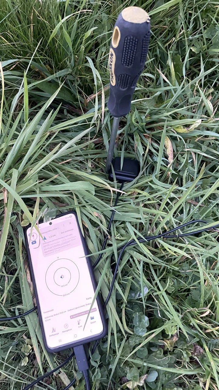
We use the LG290P with MapTools and have had very positive experiences with the receiver. For its price, the accuracy achieved in our setup is particularly convincing. The practical example is our search for a boundary marking in a meadow, using prepared target points, an Android smartphone and RTK corrections.
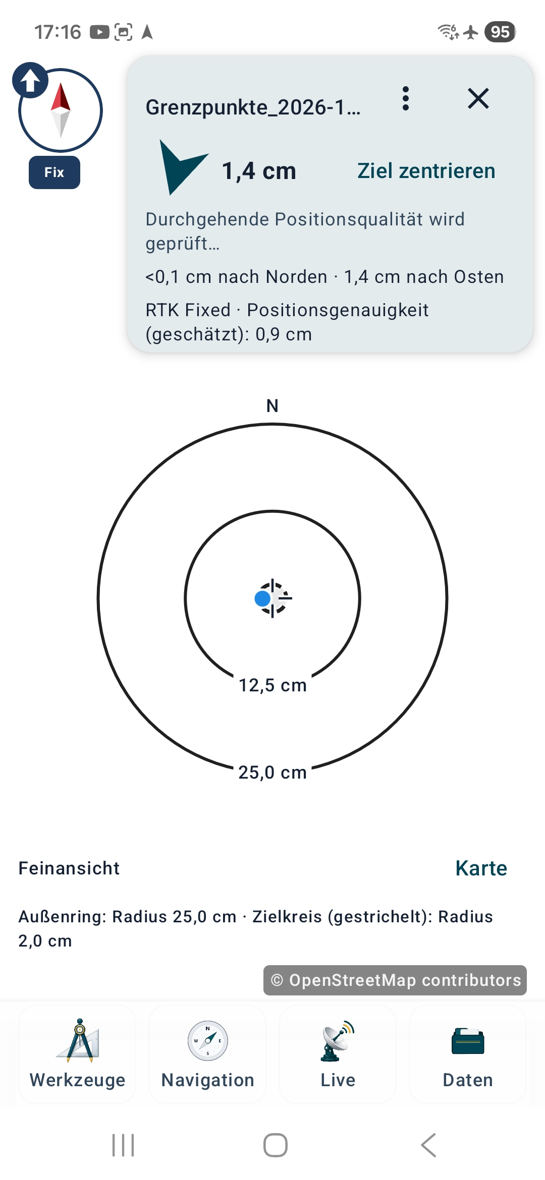
In the illustrated field example, MapTools shows RTK Fixed, 1.4 cm remaining to the saved target and 0.9 cm estimated positioning accuracy. These are different readings: neither the target distance nor the receiver estimate independently proves the actual error or the legal boundary position.
Receiver: technical specifications
Manufacturer specifications for the Waveshare board and LG290P receiver. Supported signals and functions depend on the receiver firmware; these are not measured results for every antenna and location.
| Model | Waveshare LG290P GNSS RTK Module / Quectel LG290P |
|---|---|
| Satellite systems | GPS, GLONASS, Galileo, BDS (BeiDou), QZSS, NavIC |
| Frequency bands | L1 + L2 + L5 + E6 |
| GPS signals | L1 C/A, L1C*, L2C, L5 |
| GLONASS signals | L1, L2 |
| Galileo signals | E1, E5a, E5b, E6 |
| BeiDou signals | B1I, B1C, B2a, B2b, B2I, B3I |
| QZSS signals | L1 C/A, L1C*, L2C, L5, L6 |
| NavIC / IRNSS signals | L5 |
| SBAS augmentation systems | WAAS, EGNOS, BDSBAS, MSAS, GAGAN, SDCM |
| Concurrent GNSS reception | 5 + QZSS |
| RTK operating modes | Rover and base station |
| Autonomous positioning accuracy | 0.7 m CEP |
| RTK positioning accuracy | 0.8 cm + 1 ppm CEP |
| Position update rate | 10 Hz by default; up to 20 Hz |
| Raw observation rate | 1 Hz |
| RTK convergence | Less than 5 s in the manufacturer's open-outdoor test; actual time varies |
| Time to first fix, without AGNSS | Cold / warm start: 28 s; hot start: 1.7 s |
| Receiver sensitivity | Tracking: −160 dBm; reacquisition: −155 dBm; cold start: −146 dBm |
| Velocity accuracy | 0.03 m/s |
| PPS timing accuracy | 5 ns |
| Dynamic limits | Acceleration: 4 g; altitude: 10,000 m; velocity: 490 m/s |
| Interfaces / UART baud rate | USB Type-C / UART; 4800–921600 bit/s; 460800 bit/s |
| Data protocols | NMEA 0183 / RTCM 3.x |
| Supply voltage / current | 5 V; <100 mA |
| Operating temperature | −40 … +85 °C |
| Dimensions | 33 × 33 mm |
| Board features | USB Type-C, UART connections, three status LEDs, RTC backup-battery connector and pin headers |
460800 bit/s is the factory UART setting, not a setting to apply blindly to a reconfigured unit. Waveshare marks GPS/QZSS L1C with an asterisk; do not assume availability without checking the firmware documentation. I²C communication is not supported according to the Waveshare wiki.
Included antenna: GPS External Antenna (D)
The antenna in the set described here is Waveshare GPS External Antenna (D), SKU 25346: an active L1/L5 antenna with a 3 m cable and SMA-J connector.
The receiver supports L1/L2/L5/E6, but antenna (D) is specified for L1/L5. The complete set must therefore not be described as an antenna system covering all four bands. Additional bands require an appropriate antenna and a matching receiver configuration.
| Model | Waveshare GPS External Antenna (D) / SKU 25346 |
|---|---|
| Frequency bands | L1 + L5 |
| GPS signals | L1 / L1C / L5C |
| BeiDou signals | B1I / B1C / B2a |
| Galileo signals | E1 / E5a |
| QZSS signals | L5 |
| NavIC / IRNSS signals | IRNSS S-L5 |
| Polarisation | RHCP |
| Antenna gain | 2 dBi |
| LNA gain | 28 ± 2 dB |
| Noise figure | ≤2 dB |
| Voltage standing-wave ratio | ≤2.0 |
| Output impedance | 50 Ω |
| Axial ratio | ≤3 dB |
| Specified phase-centre error | ±2 mm |
| Supply voltage / current | DC 3.0–18.0 V; ≤20 mA |
| Connector | SMA-J |
| Cable type / length | RG174; 3 m |
| Dimensions | 50.0 × 50.0 × 19.1 mm |
| Operating temperature | −40 … +85 °C |
| Storage temperature | −55 … +85 °C |
| Mounting | Magnetic base or double-sided tape |
The specified ±2 mm phase-centre error describes an antenna property. It is not a promise of ±2 mm positioning accuracy for the complete receiver setup.
Package contents and additional equipment
Waveshare lists one LG290P board, one active GNSS antenna, two 2.54 mm pin headers and two SH1.0 four-pin cables of approximately 150 mm. The antenna described on this page is model (D).
The RTC backup battery with a two-pin JST connector is optional: Waveshare offers versions with and without it. This battery preserves backup information; it does not replace the board's 5 V operating supply. The selected Amazon offer determines the actual contents.
Plan for an Android device with USB host / OTG support, a suitable USB data cable, any required adapter and sufficient power. Use a stable antenna mount and protect the exposed board from moisture. Do not assume that cables, a weatherproof enclosure or a correction-service subscription are included.
Connect the receiver to Android and MapTools
- Attach the antenna to the receiver and place it steadily with a clear view of the sky. For point measurements, centre the antenna over the point and use a defined antenna height.
- Connect the board's USB Type-C port to the Android smartphone using a data-capable cable and, if needed, an OTG adapter. Confirm Android's USB access request. The board needs a stable 5 V supply.
- Open the receiver settings in MapTools, select USB as the position source, choose the LG290P profile and the baud rate configured on your unit. An unchanged Waveshare board uses 460800 bit/s. Enable accuracy messages if needed, connect and check for valid position messages.
- For RTK, configure a suitable NTRIP service and start corrections. Check both received corrections and their delivery to the receiver, then monitor fix status and reported uncertainty. Use the linked USB guide for the full procedure and interruption handling.
NTRIP requires internet access and a suitable correction stream. Registration, geographic coverage, licence terms, mobile data and possible provider fees are separate from MapTools and the receiver purchase. A connected USB device alone does not establish an RTK fix.
What accuracy can you expect?
The LG290P can deliver very precise positions with suitable signals, antenna placement and corrections. Reception, multipath, the correction service, antenna setup and the reference system all affect the result. Our positive price/performance assessment is a personal field experience, not a controlled comparison or a guarantee of centimetre accuracy everywhere.
The manufacturer's 0.8 cm + 1 ppm CEP figure is a statistical specification, not a maximum-error guarantee. One ppm corresponds to 1 mm per kilometre of baseline. Check your own setup at a known reference point. Finding a marking or displaying RTK Fixed does not establish a legally binding property boundary.