
Check measurement accuracy
How far is your measured position from a known point? You can check this yourself with MapTools: enter the official coordinate of a reference point, find its physical mark and measure exactly there. Then compare the reference position with your measurement.
This tutorial works with your own reference points. The worked example uses horizontal control point 5215 420 00 in Fellerdilln, Hessen. Replace its details with those of your point. You can test a smartphone; a suitable RTK receiver with correction data can substantially improve the accuracy you can achieve.
Your result: an unchanged reference coordinate, at least one separately saved measured position and a comparison you can review.
The essential step: measure on the actual survey mark. Do not move the antenna during the check just to reduce the displayed distance.
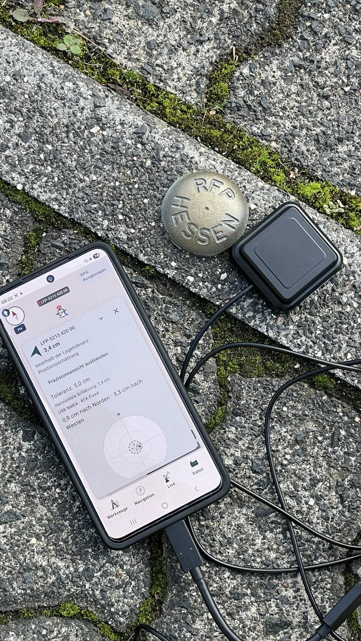
The photos and screenshots show the German interface. Follow the translated instructions; the NTRIP diagram uses the selected language.
Contents
Before you start
You need MapTools, an accessible reference point and reliable coordinates with a known reference system. For the smartphone test, enable location and grant MapTools precise location access. Charge the device and prepare an offline map if needed.
For the RTK workflow, you also need a compatible GNSS receiver with an antenna, a suitable USB connection and an activated correction service. NTRIP requires an internet connection during use. Hardware, mobile data and any provider fees are separate requirements. Position averaging and recorded RTK point measurement are Pro features; see the Free/Pro comparison for the remaining features.
| Your equipment | Your route through this tutorial |
|---|---|
| Smartphone without an external antenna | Complete steps 1–4, then use internal location and continue at step 7. In step 9, save a single position or average positions. |
| USB receiver with RTK | Also complete steps 5–6. Use RTK point measurement in step 9. |
1 Find a suitable reference point
A reference point connects a known coordinate to a clearly identifiable place on the ground. Choose a point you can safely reach and actually occupy with your antenna. Seek open sky, a stable setup and distance from reflective façades. Observe access rules and do not alter the mark.
| Point type | What it means | What it is suitable for |
|---|---|---|
| Public GNSS or GPS reference point | A point specifically provided for checking devices, often with a coordinate plaque | An accessible starting point; check rounding, reference system and quality information on the plaque |
| Horizontal control point, German abbreviation LFP | An officially documented point for horizontal positioning | Horizontal comparison against a precise reference coordinate |
| Height benchmark, German abbreviation HFP | A point with an official height reference | Height comparison; do not assume equally accurate horizontal coordinates |
| Gravity control point, German abbreviation SFP | A reference point for gravity measurements | Usually not the first choice for an ordinary horizontal GNSS test |
| Boundary point or boundary stone | A cadastral indication of a property boundary | Use only with suitable official point data; finding a stone alone does not provide a reference coordinate |
In Hessen, the HVBG provides an overview of public geodetic reference points. Official control-point information is available through AFIS, the official control-point information system. The record identifies our example as a horizontal control point, not a boundary point.
For your own point outside Hessen, search the responsible surveying authority or geoportal for GNSS reference points, control-point records or AFIS. Check access, fees, terms and documented accuracy. A map image or a point from an arbitrary web map is no substitute for the official record.
2 Obtain the official point data
Hessen example using AFIS
- Open the HVBG information about AFIS and continue to Geodaten online.
- Select “Geodätischer Raumbezug” (geodetic reference). The HVBG describes access to AFIS through the search category “Vermessungsstelle”. Choose “Produkte zeigen” (show products), then “AFIS-Einzelnachweis für Lagefestpunkte (LFP)” (individual horizontal control-point record). There is also a direct link to this product.
- If you know the identifier, use the “AFIS-Punkte” search form. In this example, the identifier contains sheet number 5215 and point number 420; also check station point 00 when selecting the record.
- If you do not yet know a point, start with “Gemeinde & Lage” (municipality and location), or obtain a control-point overview for your area. Choose an accessible point and request its individual record.
- Check the complete point identifier and follow the portal's output and ordering steps. Enter any required personal information only in the official portal. Download the individual PDF record with its description and any sketch.
The HVBG offers these AFIS products free of charge. Other products, special services or access to personal cadastral data may have different conditions. The portal's information applies. If your access does not offer a product, ask the responsible authority. Source: AFIS products and access.
What you need for your own point
Record the complete identifier, coordinate values, order and units, the coordinate reference system with zone or EPSG code, and documented horizontal accuracy. Take the description of the physical mark with you. For a height comparison, you also need the vertical reference and the exact part of the mark to which the height refers.
3 Read the individual record
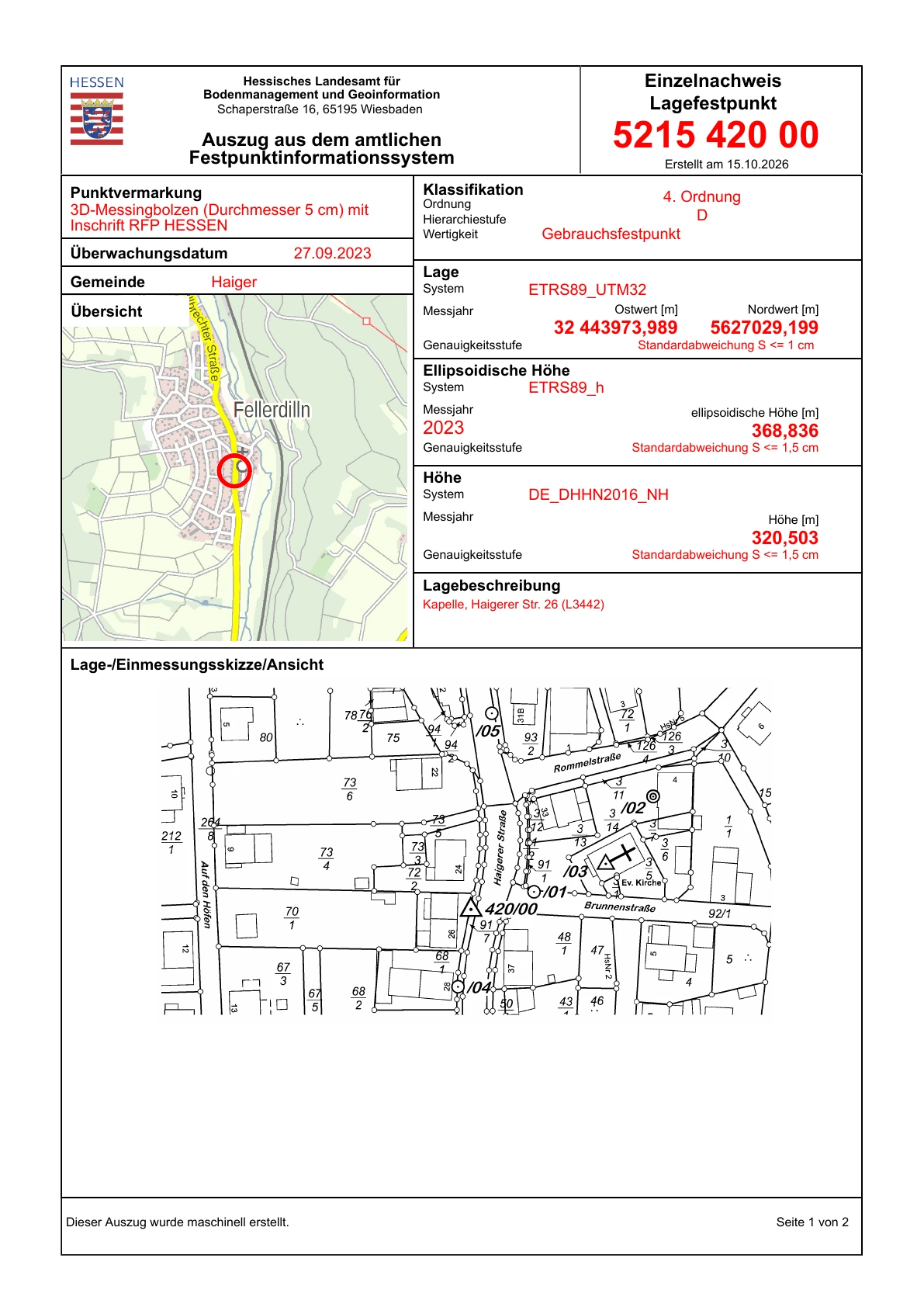
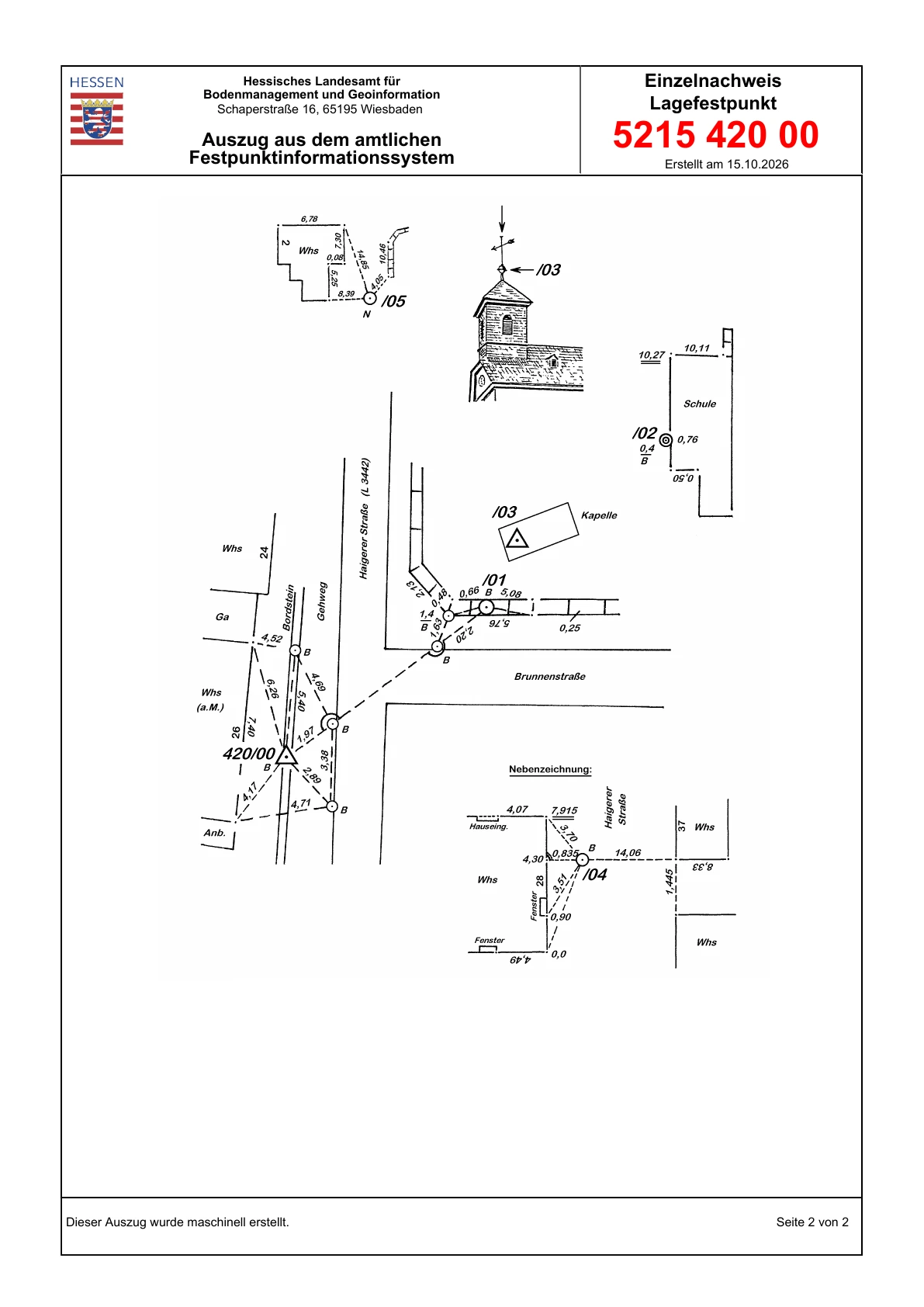
The example AFIS record contains the following information. These values apply only to the horizontal control point shown.
| Field | Fellerdilln example | How to read it |
|---|---|---|
| Point identifier | 5215 420 00 | Identify this exact point and station point on site. |
| Horizontal reference system | ETRS89_UTM32 | ETRS89, UTM zone 32 in the northern hemisphere; the corresponding code is EPSG:25832. |
| Easting | 32 443973,989 m | The leading 32 denotes the zone. The easting itself is 443973,989 m. |
| Northing | 5627029,199 m | Northing in metres. It follows the easting when entering UTM coordinates. |
| Horizontal quality | Standard deviation S ≤ 1 cm | A quality statement for the official point, not a promise for your device. |
| Ellipsoidal height | 368,836 m, ETRS89_h | Height above the reference ellipsoid. |
| Normal height | 320,503 m, DE_DHHN2016_NH | Official normal height in a different vertical reference system. |
| Physical mark and description | Brass bolt marked RFP HESSEN | Identify the actual mark and its reference point. |
Also read the measurement, monitoring and condition information. A document's creation date is not automatically the date on which all its values were measured.
Keep every digit provided. Here, three decimal places in metres represent millimetres in the written coordinate. Retaining them makes sense even when actual measurement uncertainty is larger. Other points may use different zones, reference systems or accuracy classes.
4 Save the reference coordinate in MapTools
- Open Tools → Marker → Coordinate input.
- In Input format, select the exact system specified in the record. For this example: ETRS89 / UTM zone 32N (EPSG:25832).
- Enter the easting followed by the northing, separated by a space. The input for this example is:
443973.989 5627029.199
- Check the location on the map. A point in the wrong country, a large displacement or swapped values suggests the wrong format or reference system.
- Tap Save and give the marker a clear name, such as “LFP 5215 420 00 – Reference”. Choose an easily recognised symbol and colour.
- Record the source, identifier, reference system and accuracy in the available notes. Check the saved coordinate again in the appropriate format.
Input example
| Setting | Value |
|---|---|
| Input format | ETRS89 / UTM zone 32N (EPSG:25832) |
| Coordinates | 443973.989 5627029.199 |
| Marker name | LFP 5215 420 00 – Reference |
For your own point, replace the format and both numbers with its official information.
You can also use EPSG:25832 443973.989 5627029.199 to identify the system explicitly. Do not rely on an unambiguous automatic interpretation of a bare 32 … …: the zone alone does not fully specify the datum or hemisphere. This example uses decimal points and needs no thousands separators.
Keep the reference coordinate unchanged throughout the test. Give your own measured marker a different name. This preserves the evidence of any offset from the known point.
5 Prepare the position source
Measure with the smartphone
Use internal location and wait for a fresh position. If USB was selected previously, open Settings → Device and sensors → GNSS receiver and explicitly choose Internal location (Android). USB remains selected even after disconnection. Stand at the point with open sky and continue at step 7.
A GPS profile such as “High” changes the location request. It does not turn a smartphone into an RTK receiver. Even a stationary location display can be offset from the reference coordinate.
Optionally connect a USB RTK receiver
- Connect the antenna, receiver and smartphone with suitable cables. Approve Android USB access if requested.
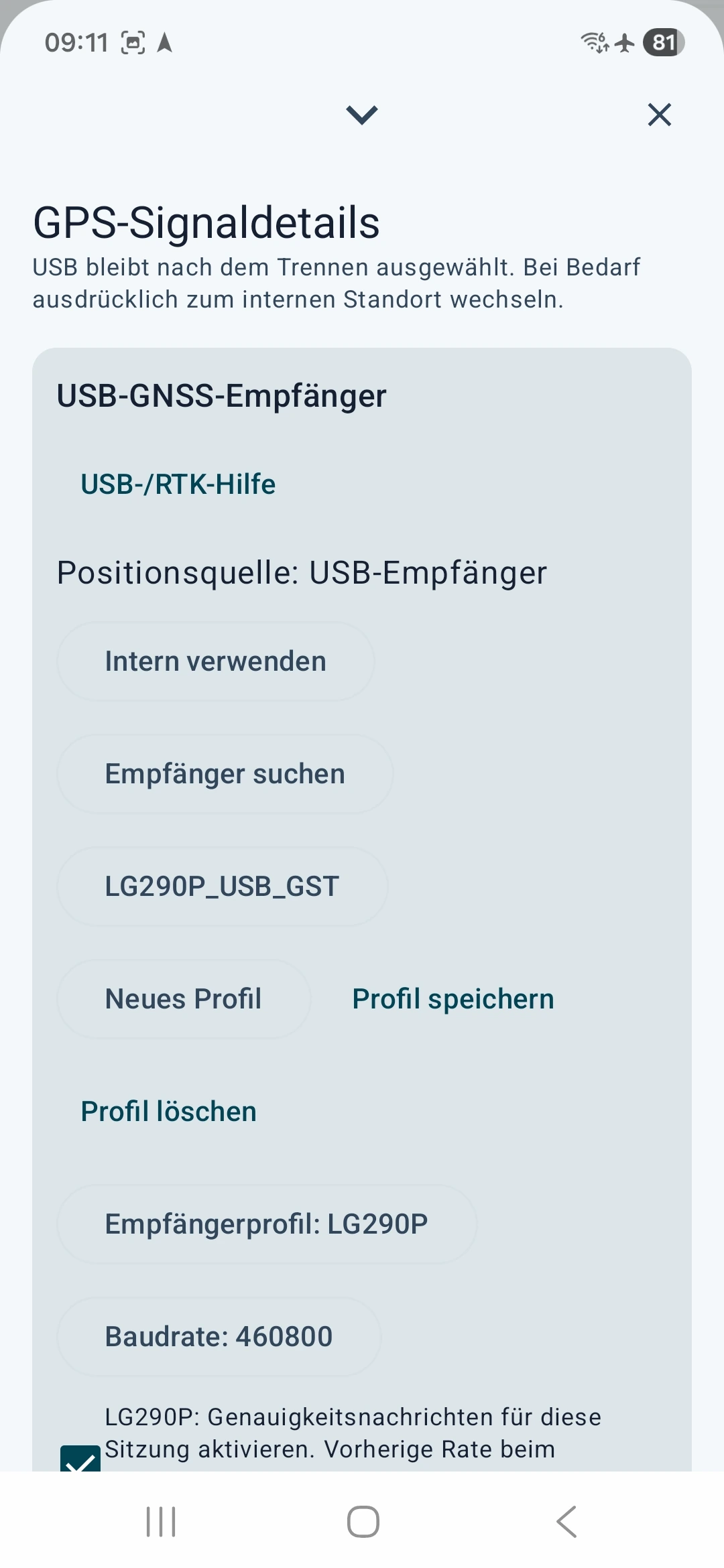
- Settings → Device and sensors → GNSS receiver
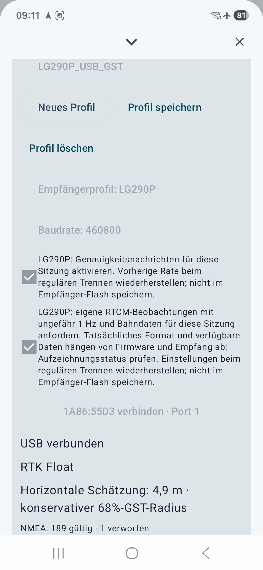
- Choose the receiver profile that matches your hardware and the manufacturer's baud rate. The pictures show an LG290P at 460800 baud as an example. Use this setting only for hardware configured accordingly.
- Connect the detected device. Check “Position source: USB receiver”, USB connected and incoming valid position messages.
- For the LG290P shown, enable accuracy messages so that quality estimates are available. The additional option for the receiver's own RTCM observations and navigation data is for raw recording; it is not required for this NTRIP test.
6 Obtain and configure NTRIP access
RTK is a method for precise GNSS positioning. NTRIP transports the required correction data over the internet. SAPOS provides such services in Germany. NTRIP access affects a measurement only when a suitable receiver actually processes the appropriate corrections.
Find a suitable service
Choose a correction service whose coverage, reference frame and RTCM format match your area and receiver. In Germany, the state surveying authority is a starting point; elsewhere, national surveying agencies or commercial providers may help. Check registration, costs, permitted use and available real-time services before going into the field.
SAPOS Hessen example:
- Open the official HVBG SAPOS page.
- Go to SAPOS Hessen registration. Download the linked registration form and submit it to the official contact address according to the provider's instructions. Complete personal details yourself.
- Request the HEPS real-time service for RTK over NTRIP. GPPS post-processing access does not replace this real-time access.
- Wait for activation and your personal access information. Keep the server, port, mountpoint, required protocol/TLS settings, username and password securely for configuration in the app.
According to the provider, Hessen's SAPOS services are free of charge. Registration, activation and your own internet connection remain necessary. Other regions may have different fees and terms. Registration · Prices and terms.
Fill in the fields in MapTools
Open Settings → Device and sensors → RTK corrections → NTRIP. Stop an active app correction connection before editing its settings. Enter the correction service's information in the appropriate fields and check it against your current provider documentation.
Enter personal information only in MapTools. This illustration shows the dialog layout; it does not accept input.
Requires your own access to a real-time RTK correction service. Registration, charges and terms depend on the provider. Access for postprocessing only is not sufficient.
Credentials are stored encrypted on this device. These settings and credentials are excluded from backups and device transfers. Saving does not start a connection.
Your correction service supplies these details
- Caster host
The provider's server name. Enter it without
http://, a port number or a path. - Port
The port number that matches the server and connection type.
- Mountpoint
Name of the authorised correction stream. Copy its spelling exactly.
- TLS
Choose according to the provider's instructions. Server, port and encryption must match.
- NTRIP version
Choose the version supported by the service: enabled for version 2, disabled for version 1.
- Username
Your personal identifier activated for the real-time service.
- Password
Your personal service password. Do not share it or include it in public images.
- Send position, GGA
Required for a VRS service. The app sends the current USB receiver position to the correction service.
- Unencrypted connection
This permission appears only when TLS is disabled. Check the provider's instructions and the privacy information beside it.
| Field in MapTools | What to enter | Public example or placeholder |
|---|---|---|
| Caster host | The server name from your access information, without http://, a path or port |
www.sapos-he-ntrip.de |
| Port | The port number for this service and transport | Public Hessen example: 2101. Use the provider's settings for other services. |
| Mountpoint | The name of the authorised data stream, exactly as supplied | Public Hessen example: VRS_3_4G_HE. Do not choose another stream just because its name looks similar. |
| TLS connection | Encryption supported by the provider, with the matching port | According to your access information. Do not combine TLS and ports arbitrarily. |
| NTRIP version 2 | The supported protocol version | According to the provider; disabling it selects version 1 in the app. |
| Username | Your personal HEPS identifier | DEINE_HEPS_KENNUNG is only a placeholder. |
| Password | Your personal service password | Enter it only in the app; this tutorial contains no usable password. |
| Send USB receiver position, GGA | Allow the required position transmission for a VRS service | Required for SAPOS Hessen VRS. Your current rover position is transmitted to that provider. |
The public Hessen examples come from the SAPOS service page / Zentrale Stelle SAPOS. Its VRS service provides RTCM corrections after receiving a GGA position. For other countries and providers, use their information instead of these Hessen examples.
Protect your credentials: prefer an encrypted connection supported by the provider. The publicly described Hessen connection on port 2101 is unencrypted. MapTools requires explicit permission for this type of service: username, password and transmitted position may be readable in transit. Check the provider's instructions; do not disable TLS merely to bypass an error.
Tap Save. This saves the settings without starting a connection. Then choose Start corrections.
Check whether corrections are working
Check these three things in order:
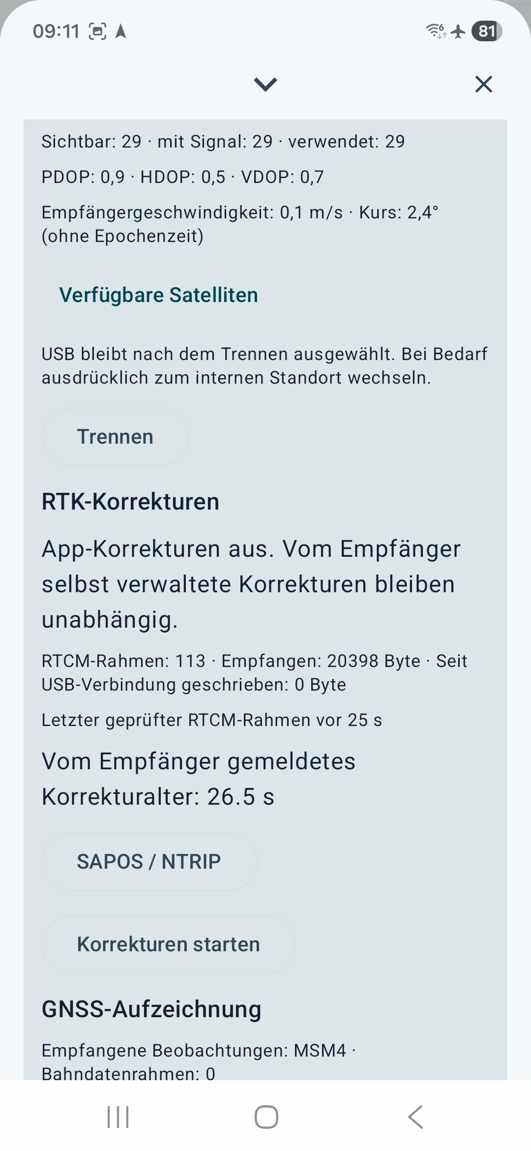
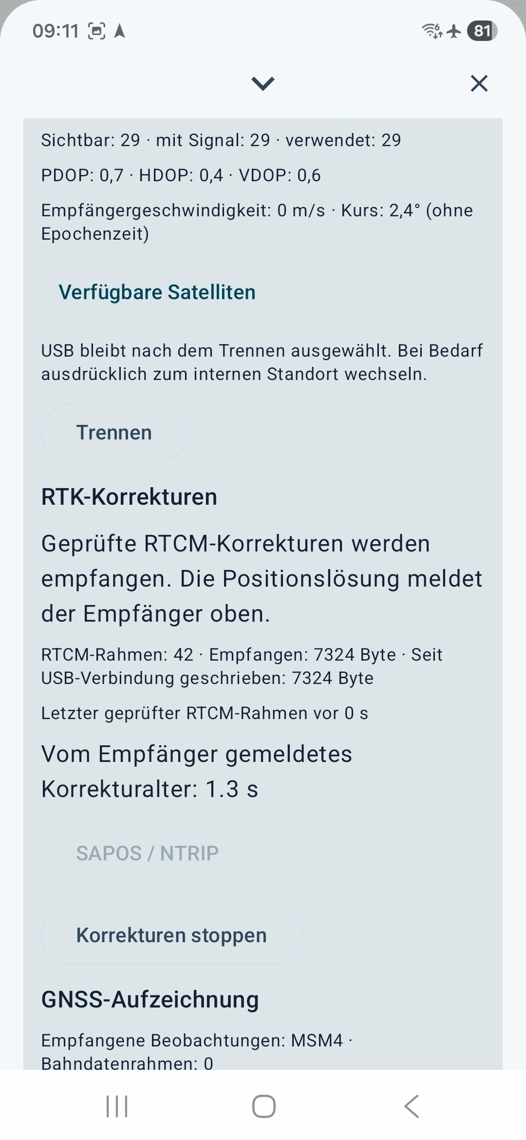
- Data flow: the app reports validated RTCM corrections and writes data to the USB receiver.
- Freshness: recent corrections should be fresh; old corrections indicate an unsuitable real-time measurement.
- Position solution: the receiver reports RTK Fixed and a suitable horizontal quality estimate. Incoming corrections alone do not confirm this state.
7 Select the reference marker as your target
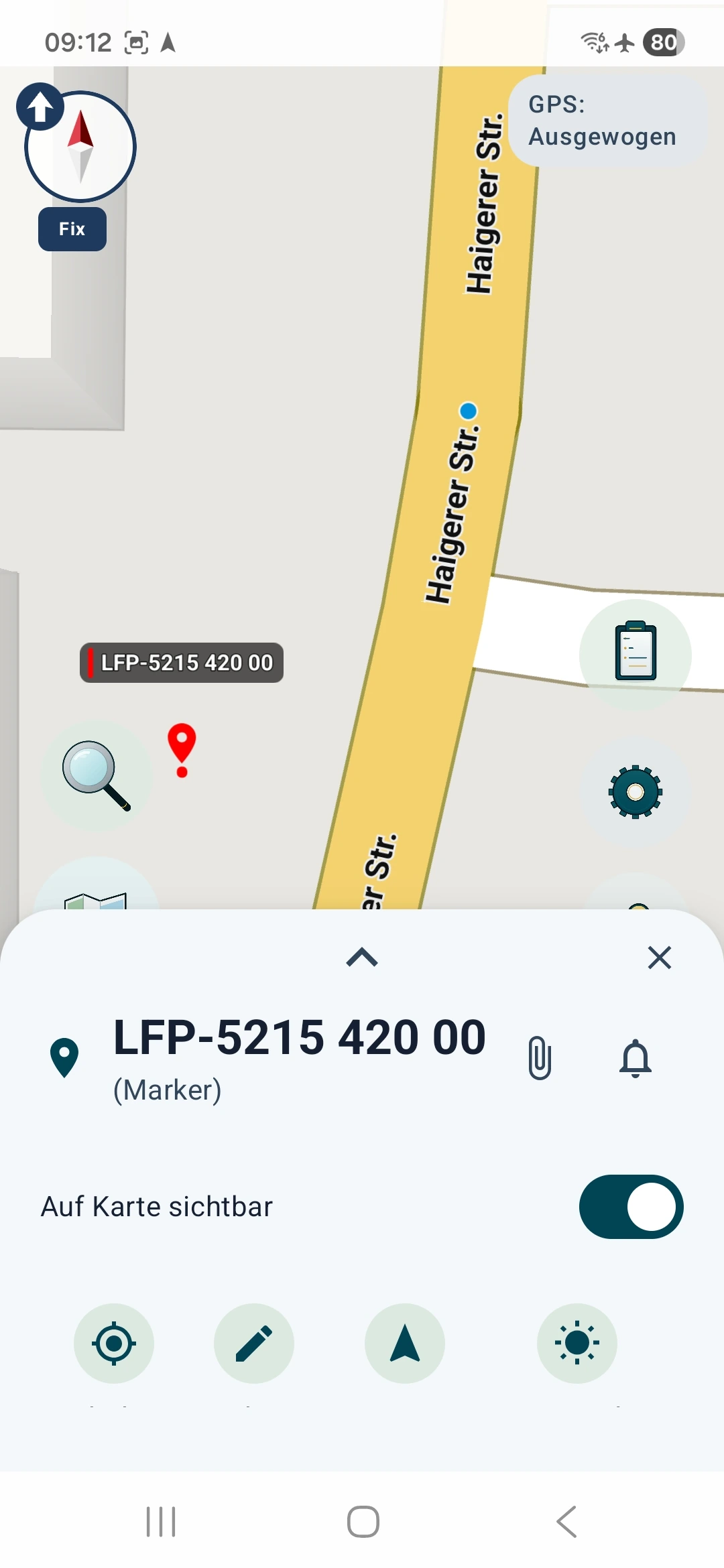
- Open your saved reference marker on the map.
- Select its “Navigation” action, identified by the arrow icon.
- Initially follow the direction and distance. Open the options using the expand arrow in the target panel.
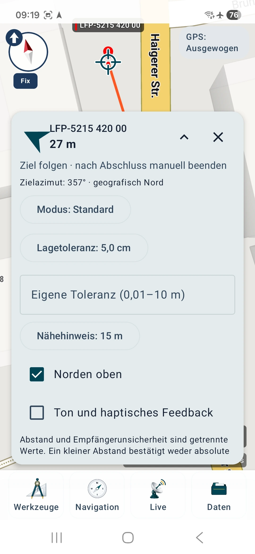
- For a smartphone test, you can remain in Standard mode. The proximity notice helps you approach but does not confirm that you are exactly on the mark.
- With RTK, choose “Mode: Find point precisely”, then Show precision view. Choose a suitable horizontal tolerance, for example 5 cm for an appropriate RTK test.
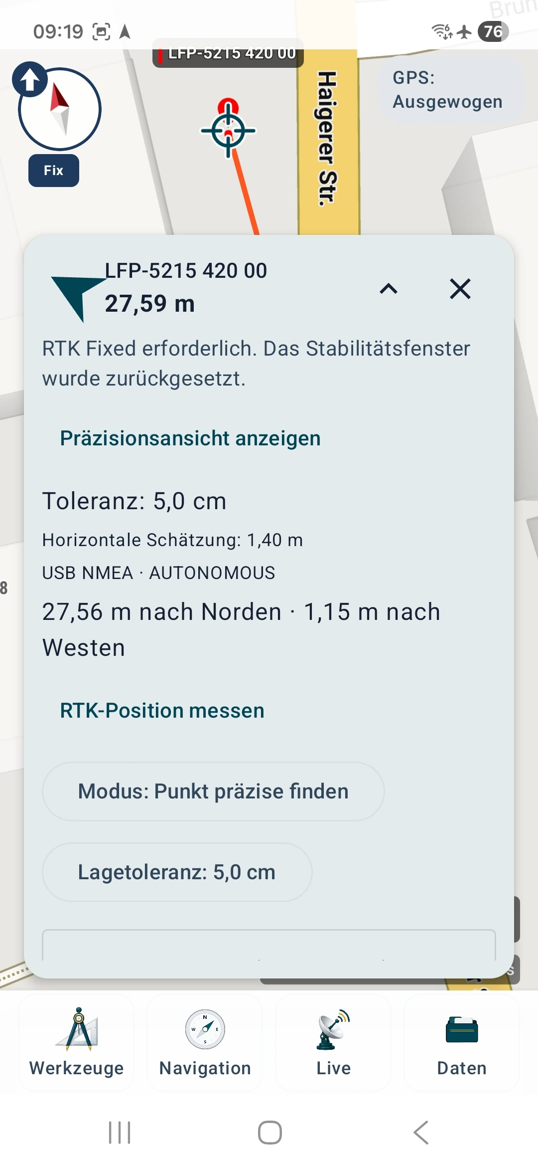
A smaller tolerance does not improve reception. A receiver reporting AUTONOMOUS or RTK Float is not reporting RTK Fixed. The precise RTK check requires Fixed; it may reset the stability window if quality is insufficient. Wait for a suitable solution and check connection, corrections and setup if needed.
8 Find the physical mark and set up the antenna
Use the official description and sketch to identify the correct bolt or mark. The map is an orientation aid; it does not establish the measurement point to centimetre accuracy.
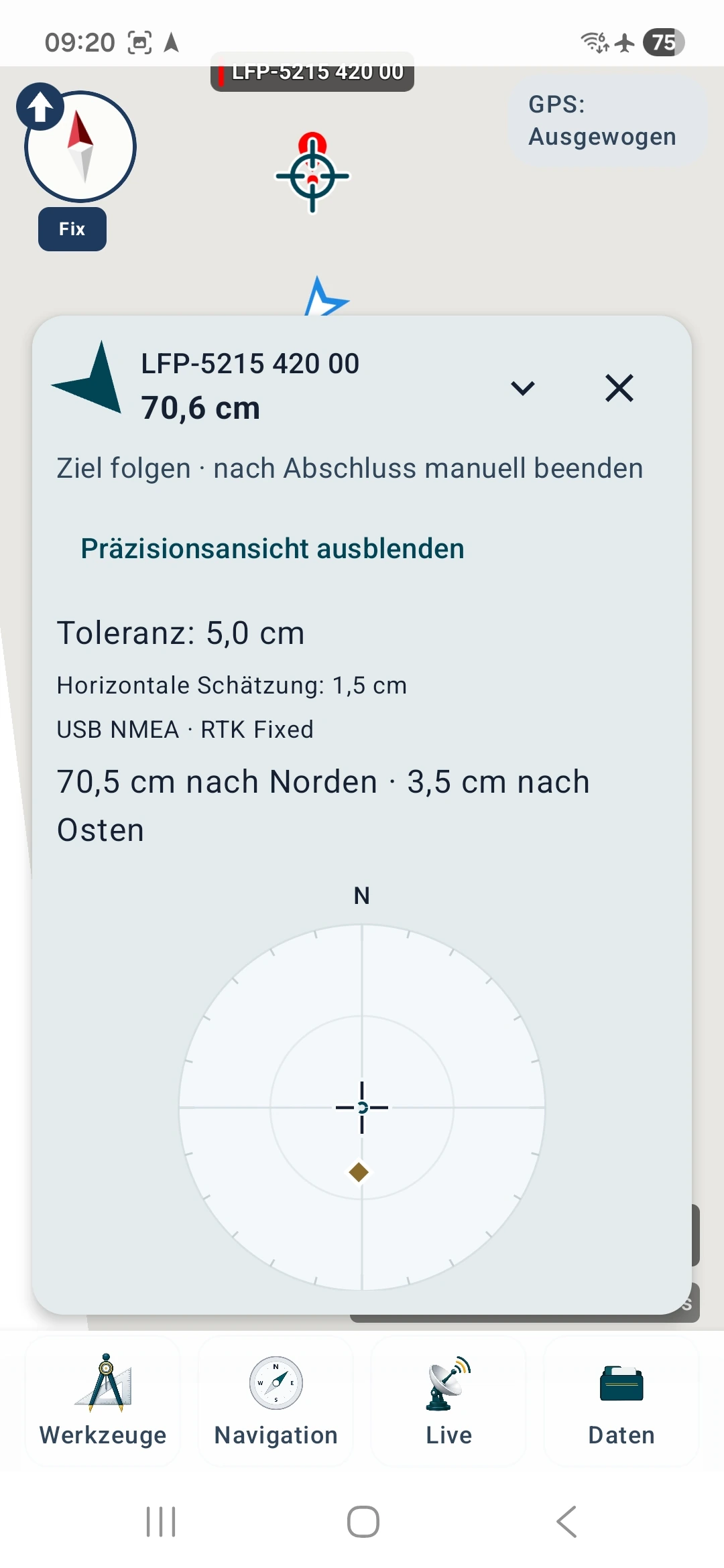
The precision view shows the target direction and remaining distance. With North up, the display uses geographic north. The diamond represents the receiver relative to the target. In the example, 70.6 cm target distance remains despite a 1.5 cm horizontal estimate. A position can be well determined while still being beside the target.
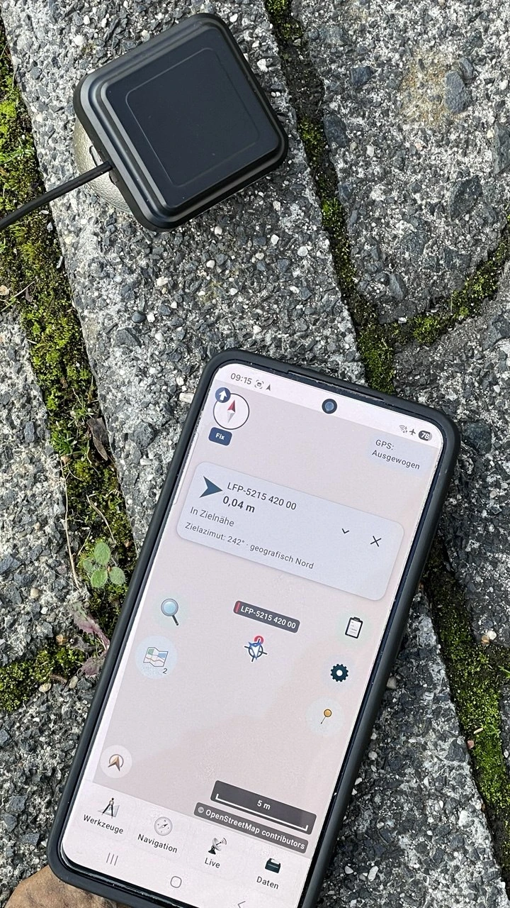
Centre the antenna over the actual reference point of the mark and keep it stable. Place or hold a smartphone reproducibly above the mark; the precise location of its internal antenna is often unknown. With an external receiver, the antenna's position matters, not that of the phone beside it.
The comparison starts now: leave the setup on the mark and read the remaining offset. Do not move the antenna to obtain “0.0”. Doing so would no longer test measurement at the known point.
9 Save the measured position separately
Capture a single position
Open Tools → Marker and choose Here (GPS). Save a new marker, for example “My reference point – Measurement 1”. This adopts the current position from the selected source. Do not use a position placed by tapping the map for this comparison.
Average the smartphone's internal positions
- Ensure that Internal location (Android) is selected. Position averaging uses internal Android location, not USB RTK positions.
- Open Tools → Marker → Average position.
- Choose a measurement profile, for example “Standard”, then tap Start GPS measurement.
- Keep the device unchanged at the point throughout recording. Wait until enough valid fixes have been collected over the required duration.
- Review the result, scatter and quality estimate. Tap Continue to marker and save a separate measured marker.
Averaging can reduce random scatter. A consistently displaced cluster can still contain systematic error. Repeat the test later under different reception conditions for a more informative assessment.
Optionally record an RTK reference measurement
- Keep the reference marker active as the navigation target and the USB receiver on the mark.
- In Precise point finding mode, open Measure RTK position.
- Check the horizontal limit and any known antenna-model and reference-frame details. Leave unknown information blank.
- To document offsets outside the selected horizontal tolerance as well, enable Measure deviation even outside target tolerance. Poor results are then not hidden solely because of target distance. Reception-quality and stability requirements still apply.
- Tap Start RTK measurement. Keep the antenna still while the app checks quality and stability.
- When complete, read the final offset, greatest offset, horizontal estimate and tolerance.
- Keep Attach report to linked point; keep its coordinate checked to attach the report to the reference marker. Uncheck it to create a separate measured marker. The official reference coordinate remains intact in both cases.
- Tap Save measurement. Then check the report on the reference marker or the newly created measured marker.
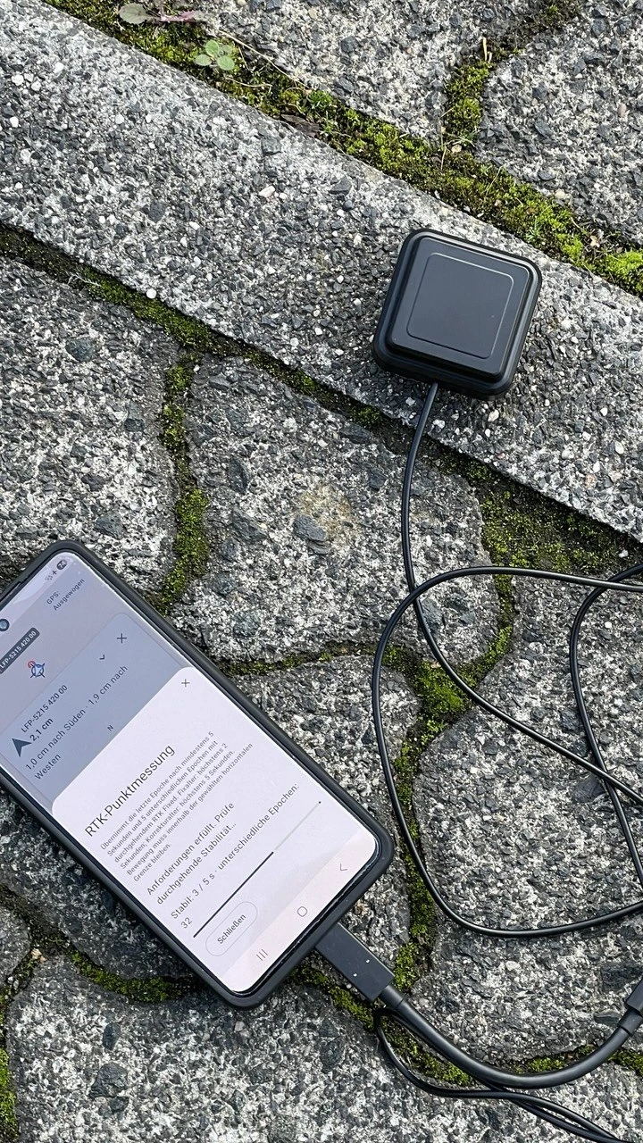
RTK point measurement requires at least 5 seconds and 5 distinct epochs with continuous RTK Fixed. Other conditions include a fix age no greater than 2 s, correction age no greater than 5 s, and suitable horizontal quality and stability. It adopts the last qualifying position; it does not average coordinates.
Target navigation remains active until you stop it explicitly. End it after the test; an active track recording is a separate operation.
10 Compare the results
Evaluate the measurement against the unchanged official reference coordinate. To compare smartphone and RTK, measure on the same physical point with documented centring and compatible reference systems. Save both results separately. Similar reception conditions help; a single test does not cover every later situation.
| Value | What it tells you |
|---|---|
| Distance or reference-to-measurement offset | How far is the measured position from the saved reference position? |
| Receiver's horizontal estimate | What horizontal uncertainty does the receiver report or estimate? |
| Scatter and stability | How much do positions change during the recording? |
| Horizontal tolerance | Which limit did you select for this comparison? |
| Reference-coordinate quality | How well is the reference point documented? |
Fellerdilln worked example
On 20 October 2026, two RTK point measurements were made at horizontal control point 5215 420 00 using an LG290P USB receiver and SAPOS HEPS corrections over NTRIP. The antenna rested directly on the bolt at ground level. For this comparison, the saved final positions were evaluated against the complete official reference coordinate 443973.989 / 5627029.199, ETRS89 / UTM 32N.
| Measurement, local time CEST | Calculated horizontal distance from the AFIS reference position |
|---|---|
| First measurement, ended 09:23:07 | approximately 2.0 cm |
| Second measurement, ended 09:27:08 | approximately 1.6 cm |
These are the distances for the adopted final positions, not the receiver's uncertainty estimates. The second window documents 52 distinct RTK Fixed positions over approximately 5.1 seconds. Their calculated distances from the official point are all approximately 1.4 to 2.0 cm. The complete position sequence for the first measurement is unavailable for this later comparison, so no corresponding range is given.
How to interpret these numbers: the calculation numerically treated receiver coordinates as ETRS89. The actual receiver reference frame is not documented in the measurement records. The official horizontal quality of S ≤ 1 cm and antenna centring must also be considered. The values therefore show close numerical agreement in this test; they do not establish general absolute accuracy for other setups or conditions.
The app's original target distances used a rounded reference marker approximately 3.4 cm from the full official coordinate. This table therefore uses a later comparison against the complete AFIS value. For centimetre checks in particular, verify the saved reference coordinate before measuring.
This example gives no confirmed height accuracy. The receiver output's vertical reference and height to the antenna reference point were insufficiently documented; see step 11.
What difference RTK can make
Basic GNSS tests may show metre-scale offsets. SAPOS Hessen describes 1–2 cm horizontal accuracy for its HEPS service with suitable RTK use. Whether your setup achieves this depends on reception, multipath, corrections, antenna and centring, among other factors. Source: SAPOS HEPS.
For example, our images show a 4.9 m horizontal estimate with RTK Float and later 1.5 cm with RTK Fixed. These are estimates at different moments, not a controlled demonstration of an equivalent improvement in absolute error. Your test depends on the actual observed offset from the reference point.
When comparing metric coordinates, first calculate the easting and northing differences. An illustrative example with arbitrary values: 3 cm easting error and 4 cm northing error give approximately 5 cm horizontal distance. UTM differences describe distance in the projection grid; centimetre work over longer distances requires attention to projection scale and a suitable geodetic method.
Check the reference system: do not treat ETRS89 and WGS84 as equivalent without verification for centimetre comparisons. Differences in reference frame, realisation or, where relevant, epoch can make a small numerical difference misleading. An unknown receiver reference limits the comparison. A control point connected to the same reference network is also not an independent test of the whole network.
Your measurement record
| Note | Your entry |
|---|---|
| Point identifier and source | … |
| Reference coordinate, system and horizontal quality | … |
| Date, time and conditions | … |
| Device, position source and antenna | … |
| Centring and known antenna height | … |
| Measured position | … |
| Position status and horizontal estimate | … |
| Correction age for RTK | … |
| Observed reference-to-measurement offset | … |
| Repetition and observations | … |
Repeat the setup and measurement independently rather than merely counting consecutive fixes. Keep results outside your tolerance too. This helps show whether a good individual result is repeatable.
11 Optionally check the height
A horizontal check does not initially require height correction. For a height comparison, however, the vertical and antenna references must match. The AFIS example gives 368.836 m ellipsoidal height and 320.503 m normal height as different quantities.
A receiver's MSL height is not automatically an official DHHN2016 normal height above NHN. Check the receiver's model and vertical reference. Merely changing the coordinate display format does not perform a verified height transformation.
Enter an antenna height in the RTK measurement only when the vertical height to the antenna reference point, ARP, is known. If the receiver already accounts for this height, select the corresponding option and avoid applying it twice. Even an antenna resting directly on a bolt does not necessarily have its ARP at the bottom of the housing. MapTools does not perform tilt compensation or vertical-reference transformation here.
12 Solve common problems
| Observation | What to check |
|---|---|
| The reference coordinate is far away | Compare order, units, signs, UTM zone, hemisphere and reference system against the official record. |
| No position after disconnecting USB | Settings → Device and sensors → GNSS receiver → Internal location (Android) |
| Position averaging does not work with USB | Use internal location for averaging; use RTK point measurement for the USB RTK receiver. |
| NTRIP login is rejected | Check your personal identifier, password and HEPS activation with the provider. Enter credentials only in the app. |
| Mountpoint unavailable | Check spelling, activation, area and data format against current provider documentation. |
| Secure connection fails | Check host, port and TLS requirements. Do not bypass a certificate error by arbitrarily switching to an insecure connection. |
| Corrections are running but RTK Fixed is missing | Check the appropriate stream, fresh GGA position for VRS, correction age, antenna reception and receiver compatibility. |
| Corrections stop in offline mode | Use a permitted internet connection for NTRIP and restart corrections after returning online. |
| The RTK stability check restarts | Check movement, stale fixes or corrections, quality estimate and continuous Fixed status. |
| The reading is stable but beside the bolt | Check reference coordinate, reference frame, centring and possible reflections; repeat independently on the mark. |
Protect credentials and personal information
Enter usernames and passwords only in the designated app fields. Do not use them as profile or marker names. Share only necessary information with support and redact personal identifiers, passwords, tokens, customer numbers and private contact details. Check measurement reports and file metadata before publishing them.
This tutorial uses only placeholders and publicly documented service details for login. Your own credentials, completed registration forms and private documents do not belong in a screenshot gallery. With VRS, the selected correction provider receives your rover position; consider this when choosing the provider and granting permission.
Final checklist
- Have you clearly identified the correct physical point, and is it accessible?
- Do the full reference coordinate and its reference system match the official record?
- Did you measure on the mark without moving the antenna to reduce the displayed residual error?
- Are the reference marker and measured position preserved separately?
- Are the position source, quality, corrections and setup documented clearly?
- Have you repeated the test independently and recorded poorer results too?
The comparison shows your setup's observed positioning performance under those conditions. It is not an official boundary determination and does not calibrate the smartphone or antenna.
Further guides and sources
- MapTools: coordinates
- MapTools: target navigation
- MapTools: position averaging
- MapTools: USB GNSS, RTK and NTRIP
- HVBG: AFIS and obtaining control-point data
- HVBG: AFIS product sheet explaining the records
- HVBG: public geodetic reference points
- Geodaten online
- SAPOS Hessen: registration, services, prices and terms
The example values come from the HVBG's AFIS record for horizontal control point 5215 420 00. Obtain a current record for your own point before measuring.