
MapTools for your use case
Search grids, tracks and offline maps for ground search teams
Prepare search areas, document travelled sections and make spatial coverage visible for a structured team debrief.

Typical workflow
A search grid starts with a clearly bounded working area
Create a suitable area or circle before starting and review offline maps, terrain boundaries and access points. Cell size and planned search width need to fit the terrain, visibility, procedure and practically achievable GPS accuracy.

Tools in the field
What MapTools does for Search teams & ground search
The essential tools form one clear mobile workflow and remain usable without a continuous data connection when maps and data have been prepared in advance.
- Prepare search areas and evenly spaced grid lines on the map
- Record GPS tracks for sections and compare coverage
- Exchange points, areas and tracks in common geodata formats
Typical workflow
A typical ground-search workflow in MapTools
The mobile workflow supports preparation, technical progress display and review. Leadership, briefing, communication and safety decisions remain outside the app.
- 1Define the base area
Create the intended search area as an area or circle and review it on a suitable map that is preferably available offline.
Areas on the map - 2Configure the search grid
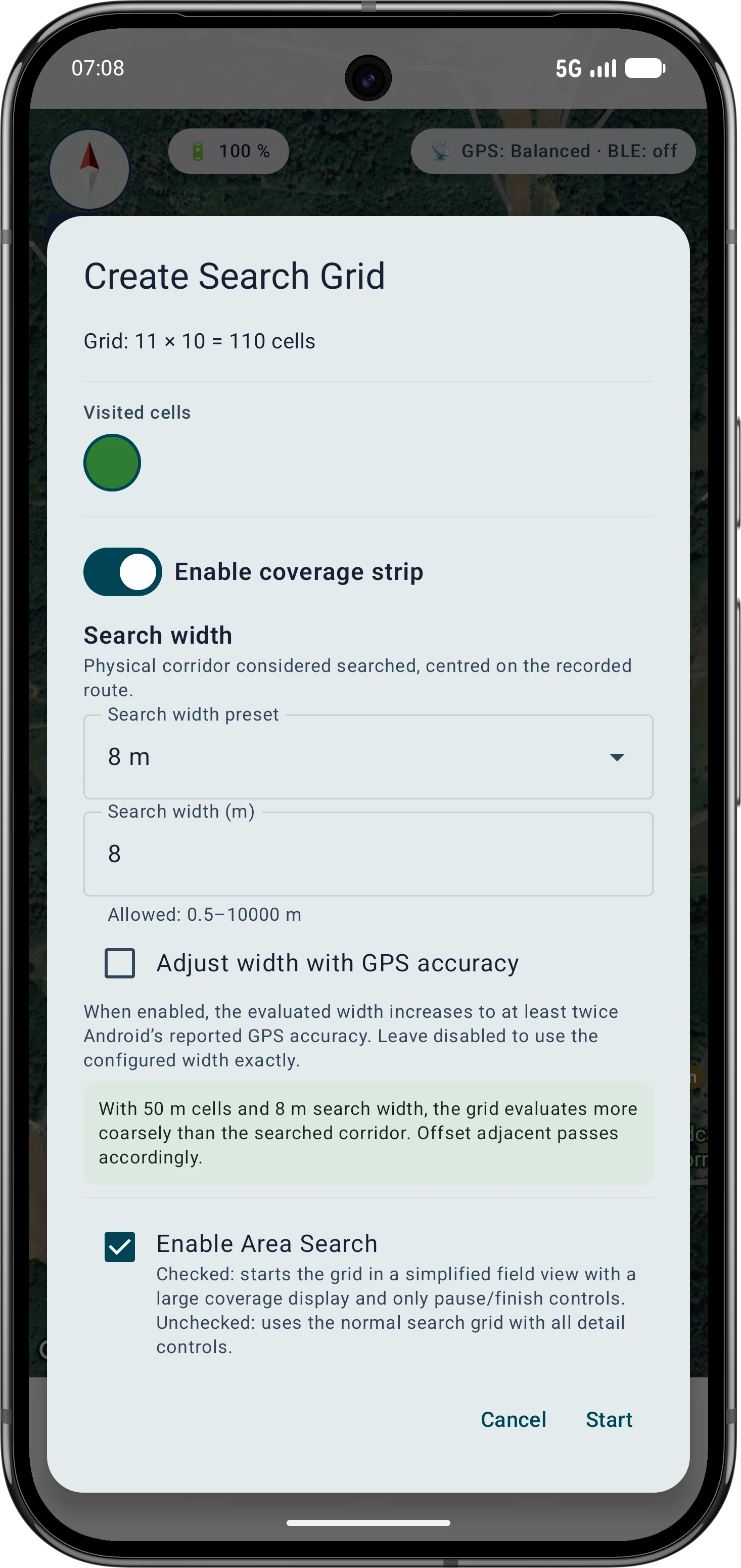
Select the base object, review cell size and estimated cell count, then choose the normal grid or simplified area-search view.
Set up a search grid - 3Record technical coverage
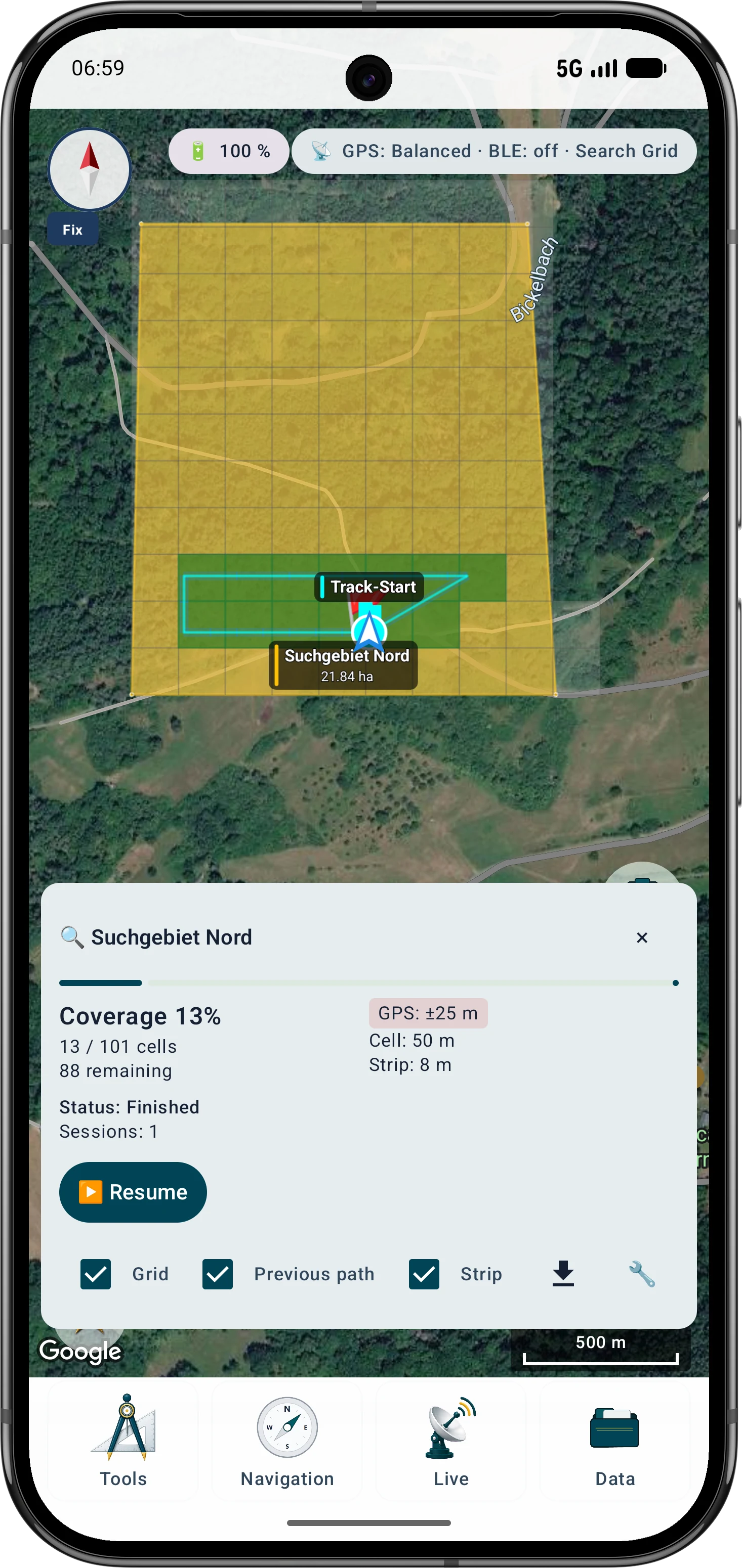
Start with a usable GPS fix. MapTools marks visited cells from the reported device position; recording can be paused and resumed.
Coverage and controls - 4Save and review the result
Review grid progress, sessions and any separately recorded tracks. A MapTools project is better suited to preserving the complete project state than a general exchange format.
Projects and export
Tools in the field
After the search, technical coverage must remain separate from search quality
A visited cell means that the position reported by Android entered that cell. It does not prove visual contact or a completely searched area. Review grid progress, GPS quality, pauses, obstacles and the actual search method together.
- Review visited and remaining cells together with session boundaries
- Account for GPS error, terrain, obstacles and the actual search width
- Deliberately save the project state and exchange relevant tracks in supported formats

Inside the app
Search grid and coverage in the app
Select the base object, review cell size and estimated cell count, then choose the normal grid or simplified area-search view. Start with a usable GPS fix. MapTools marks visited cells from the reported device position; recording can be paused and resumed.
Go deeper
Optional: see nearby participants with Live Groups
Live Groups can exchange position, freshness and short status information between nearby devices over Bluetooth Low Energy. They do not use an ArxSilex cloud server and do not replace radio or central incident management. Range and reliability depend heavily on the phone, Android, permissions, power saving, body shielding and terrain.
Important in the field
Understand the practical limits
MapTools can support trained teams with mapping and documentation, but it is not a certified incident-command, alerting or rescue system. The organisation's official procedures, leadership, communications and safety rules remain authoritative.
FAQ
Common questions about MapTools for search teams
Does the search grid work without mobile reception?
Yes, when the map, base area and required project data have been prepared locally. GPS and grid evaluation can work without mobile service; online maps and external services still need a connection.
When is a grid cell considered visited?
When the GPS position reported by Android enters the cell. This is a technical progress indicator, not proof that every part of the cell was visible or searched according to procedure.
Can MapTools centrally merge results from several team members?
Points, areas, tracks and projects can be exchanged deliberately. MapTools does not promise an automatic central incident record or cloud merge. Live Groups provide an optional nearby display without a central ArxSilex history.
Does MapTools replace incident command, radio or rescue systems?
No. MapTools supports map work and documentation. Responsibilities, briefing, communication, safety decisions and official records remain governed by the organisation.
ArxSilex MapTools
Try MapTools for Search teams & ground search
Start with the quick guide or install MapTools on your Android device.
Help shape MapTools
Which feature would you still like to see?
What is missing from your typical workflow, what should work differently, or which information is missing from this page? Tell us about your workflow and the specific need. Your feedback helps us improve MapTools for real field use.