
Finding boundary stones with RTK in Hesse
Use phone GPS for orientation. For RTK, configure the LG290P and SAPOS HEPS before heading into the field.
External GNSS receiver (USB)
The photos and screenshots show the German interface. Follow the translated instructions; the NTRIP diagram uses the selected language.
- Connect the antenna, receiver and smartphone with suitable cables. Approve Android USB access if requested.
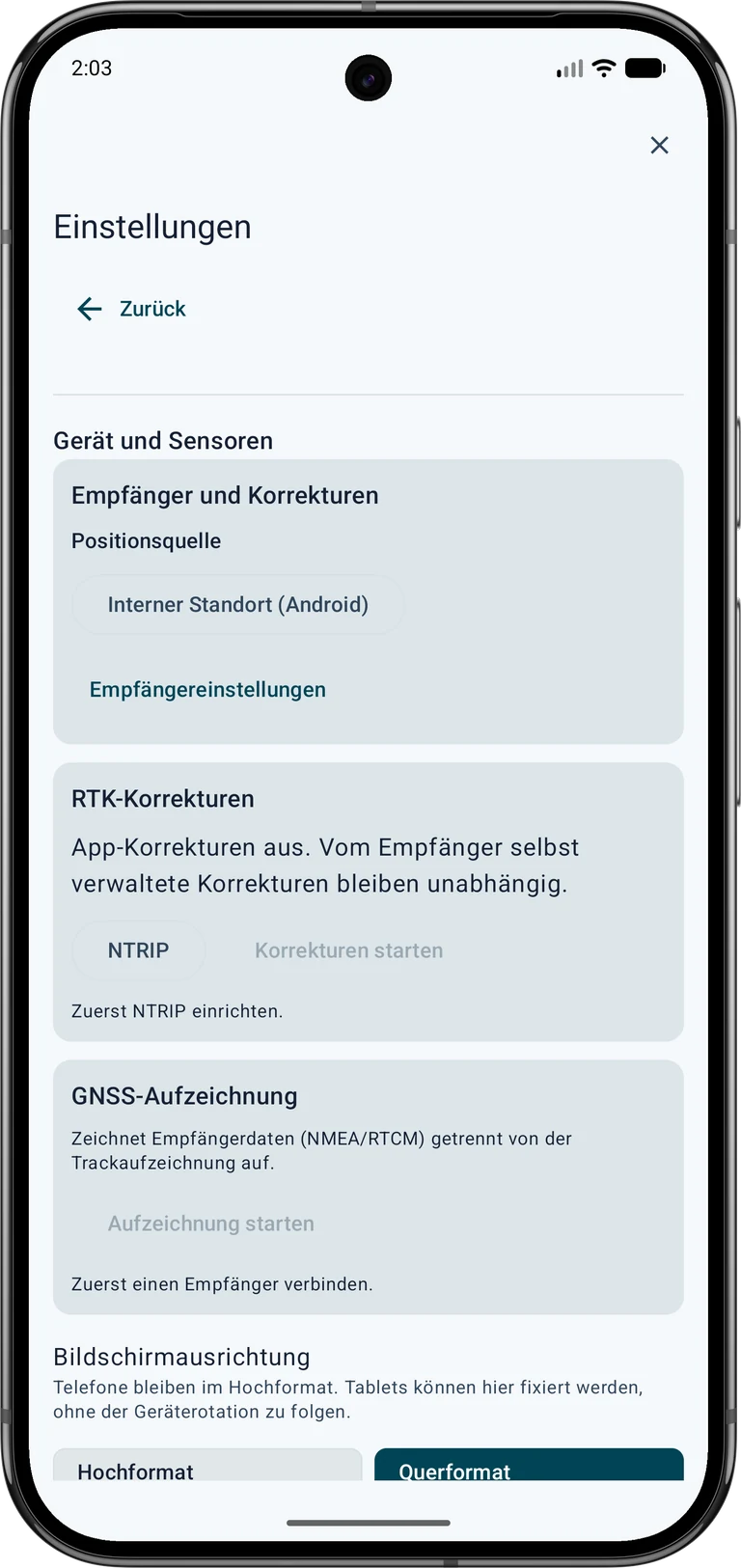
 Settings → Device and sensors → GNSS receiver → Position source
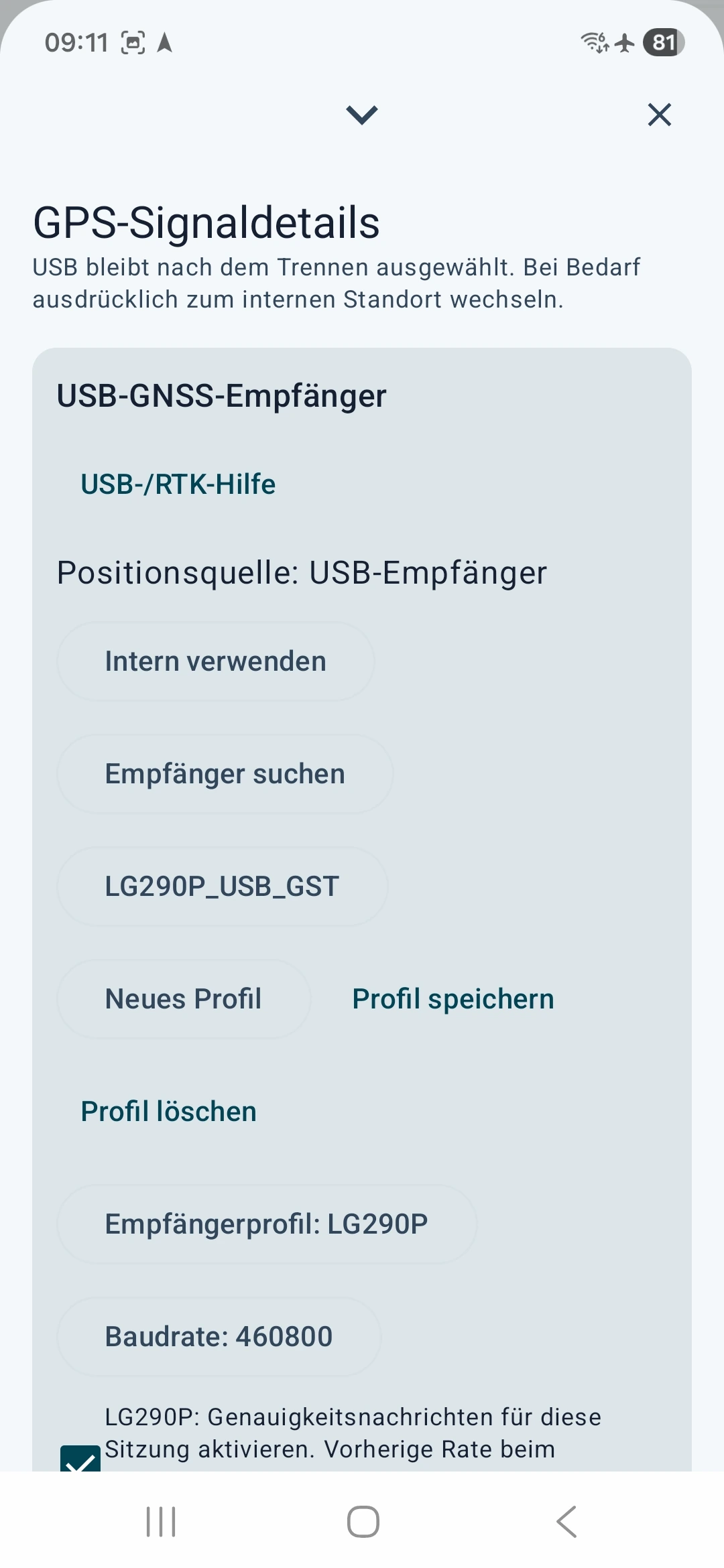
Internal location (Android) ▾ → External GNSS receiver (USB)- Find receivers → Receiver settings ▾
- Choose the receiver profile that matches your hardware and the manufacturer's baud rate. The pictures show an LG290P at 460800 baud as an example. Use this setting only for hardware configured accordingly.
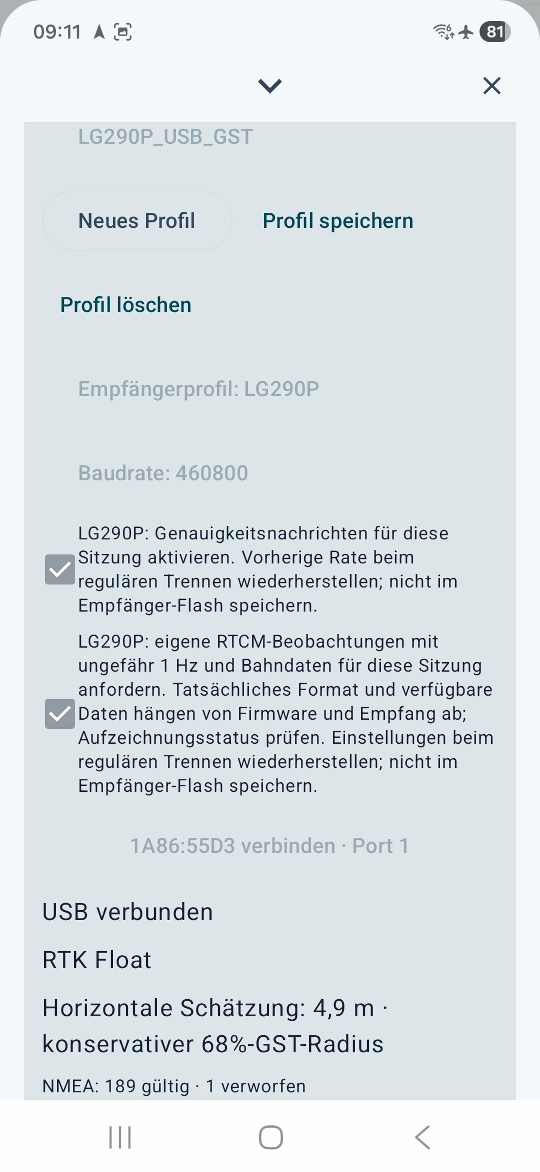
- For the LG290P shown, enable accuracy messages so that quality estimates are available. The additional option for the receiver's own RTCM observations and navigation data is for raw recording; it is not required for this NTRIP test.
- Connect the detected device. Check “Position source: USB receiver”, USB connected and incoming valid position messages.
Obtain and configure NTRIP access
RTK is a method for precise GNSS positioning. NTRIP transports the required correction data over the internet. SAPOS provides such services in Germany. NTRIP access affects a measurement only when a suitable receiver actually processes the appropriate corrections.
Find a suitable service
Choose a correction service whose coverage, reference frame and RTCM format match your area and receiver. In Germany, the state surveying authority is a starting point; elsewhere, national surveying agencies or commercial providers may help. Check registration, costs, permitted use and available real-time services before going into the field.
SAPOS Hessen example:
- Open the official HVBG SAPOS page.
- Go to SAPOS Hessen registration. Download the linked registration form and submit it to the official contact address according to the provider's instructions. Complete personal details yourself.
- Request the HEPS real-time service for RTK over NTRIP. GPPS post-processing access does not replace this real-time access.
- Wait for activation and your personal access information. Keep the server, port, mountpoint, required protocol/TLS settings, username and password securely for configuration in the app.
According to the provider, Hessen's SAPOS services are free of charge. Registration, activation and your own internet connection remain necessary. Other regions may have different fees and terms. Registration · Prices and terms.
Fill in the fields in MapTools
Open Settings → Device and sensors → RTK corrections → NTRIP. Stop an active app correction connection before editing its settings. Enter the correction service's information in the appropriate fields and check it against your current provider documentation.
| Field in MapTools | Public example or placeholder | What to enter |
|---|---|---|
| Caster host | www.sapos-he-ntrip.de | The server name from your access information, without http://, a path or port |
| Port | 2101 | The port number for this service and transport. Public Hessen example: 2101. Use the provider's settings for other services. |
| Mountpoint | VRS_3_4G_HE | The name of the authorised data stream, exactly as supplied. Public Hessen example: VRS_3_4G_HE. Do not choose another stream just because its name looks similar. |
| TLS connection | No | Encryption supported by the provider, with the matching port. According to your access information. Do not combine TLS and ports arbitrarily. |
| NTRIP version 2 | Yes | The supported protocol version. According to the provider; disabling it selects version 1 in the app. |
| Username | DEINE_HEPS_KENNUNG is only a placeholder. | Your personal HEPS identifier |
| Password | Enter it only in the app; this tutorial contains no usable password. | Your personal service password |
| Send USB receiver position, GGA | Yes | Allow the required position transmission for a VRS service. Required for SAPOS Hessen VRS. Your current rover position is transmitted to that provider. |
| Unencrypted connection | Yes | This permission appears only when TLS is disabled. Check the provider's instructions and the privacy information beside it. |
Enter personal information only in MapTools. This illustration shows the dialog layout; it does not accept input.
Requires your own access to a real-time RTK correction service. Registration, charges and terms depend on the provider. Access for postprocessing only is not sufficient.
Credentials are stored encrypted on this device. These settings and credentials are excluded from backups and device transfers. Saving does not start a connection.
Your correction service supplies these details
- Caster host
The provider's server name. Enter it without
http://, a port number or a path. - Port
The port number that matches the server and connection type.
- Mountpoint
Name of the authorised correction stream. Copy its spelling exactly.
- TLS
Choose according to the provider's instructions. Server, port and encryption must match.
- NTRIP version
Choose the version supported by the service: enabled for version 2, disabled for version 1.
- Username
Your personal identifier activated for the real-time service.
- Password
Your personal service password. Do not share it or include it in public images.
- Send position, GGA
Required for a VRS service. The app sends the current USB receiver position to the correction service.
- Unencrypted connection
This permission appears only when TLS is disabled. Check the provider's instructions and the privacy information beside it.
The public Hessen examples come from the SAPOS service page / Zentrale Stelle SAPOS. Its VRS service provides RTCM corrections after receiving a GGA position. For other countries and providers, use their information instead of these Hessen examples.
Protect your credentials: prefer an encrypted connection supported by the provider. The publicly described Hessen connection on port 2101 is unencrypted. MapTools requires explicit permission for this type of service: username, password and transmitted position may be readable in transit. Check the provider's instructions; do not disable TLS merely to bypass an error.
Tap Save. This saves the settings without starting a connection. Then choose Start corrections.
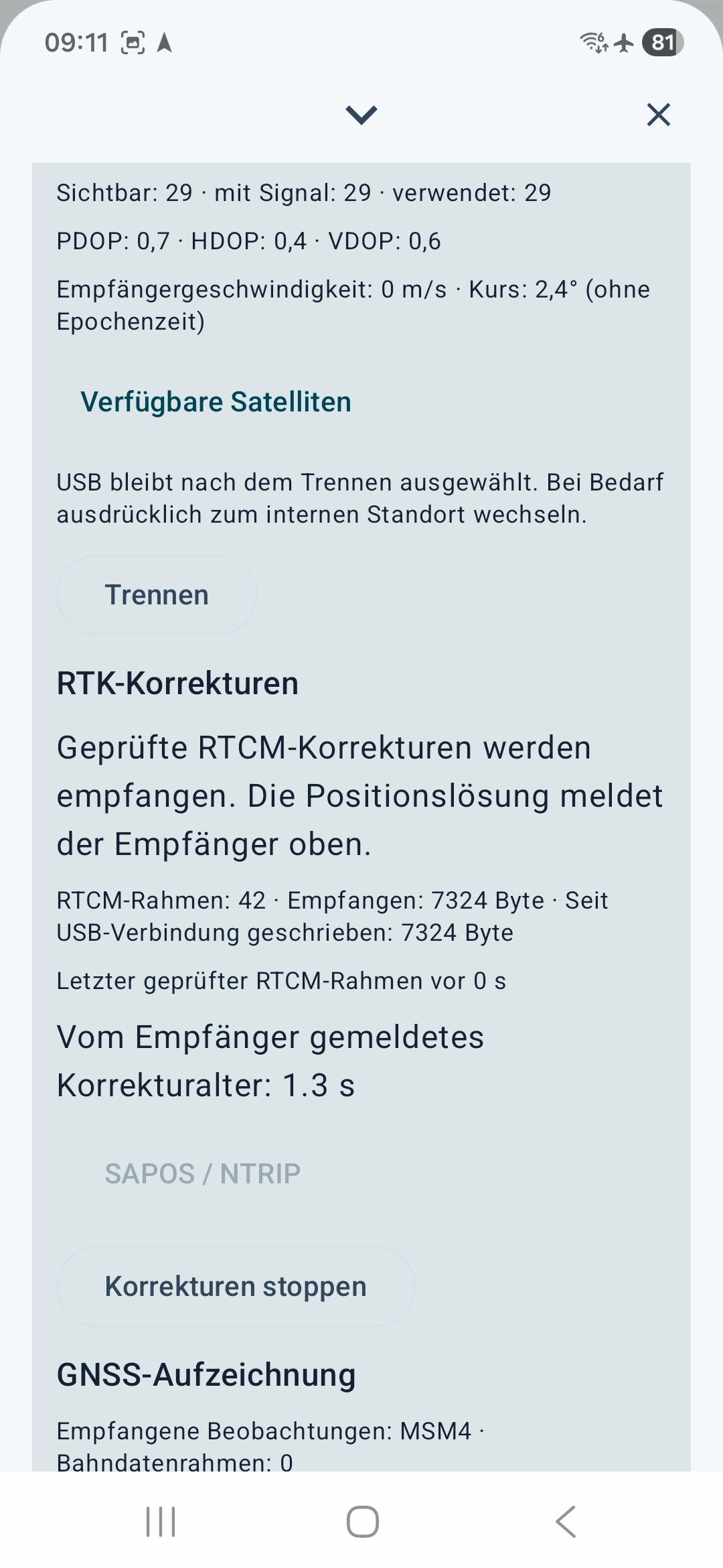
Check whether corrections are working
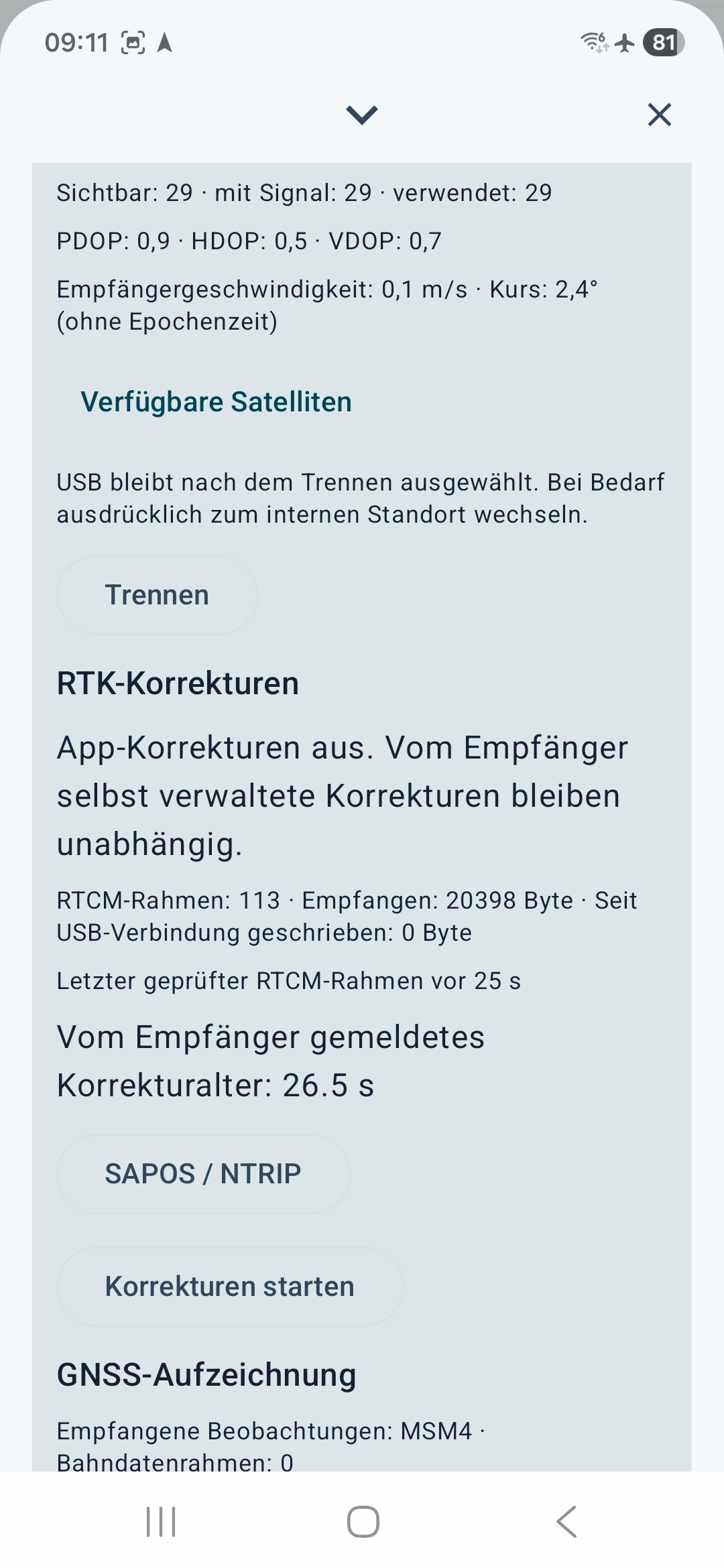
Check these three things in order:
- Data flow: the app reports validated RTCM corrections and writes data to the USB receiver.
- Freshness: recent corrections should be fresh; old corrections indicate an unsuitable real-time measurement.
- Position solution: the receiver reports RTK Fixed and a suitable horizontal quality estimate. Incoming corrections alone do not confirm this state.
Connect a suitable cadastral service
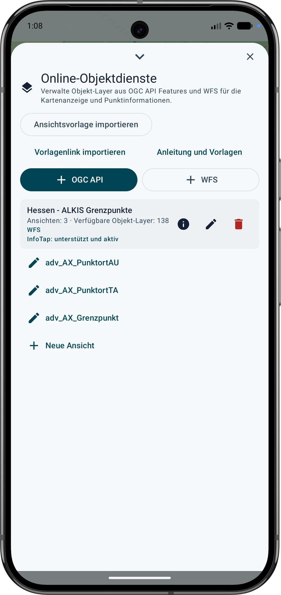
 Touch and hold the map icon, then choose Manage maps in Maps & map data.
Online map services → Object layers (OGC API / WFS) → + WFS
Service name · Hessen – ALKIS
Authentication · None
HTTPS service endpoint ·https://www.gds.hessen.de/wfs2/aaa-suite/cgi-bin/alkis/sf/wfs?SERVICE=WFS&VERSION=2.0.0&REQUEST=GetCapabilities- Tap Discover object layers. Select
adv:AX_PunktortAUfor the official position andadv:AX_PunktortTAfor the map position. Addadv:AX_Grenzpunktif you need the point identifier and marker information. When you save, MapTools creates views for the selected layers. - Enable the views under Online object layers in the desired map slot. Turn on Include in point information if you want to open the attributes with InfoTap. Zoom in to the search area with no filter. Narrow the area if MapTools reports partial results. Prefer the official position (AU) as your target.
To filter by marker type, use the linked Hesse view of adv:AX_Grenzpunkt. Check that the points appear before applying a filter. Preview without filters first. Then Add condition → abmarkung_Marke → equals → 1110. This code means boundary stone; other stone types have separate codes. 1200 means pipe, 1300 bolt/nail and 9500 no marker. A boundary point is therefore not necessarily a stone. Combine several desired codes with At least one.
Choose a reliable target point

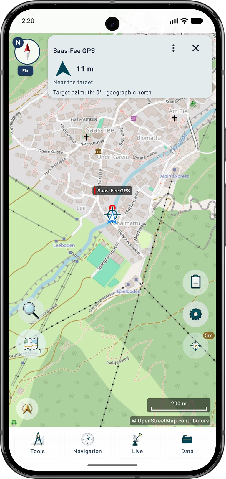
 Tap the boundary point on the map. If needed, press and hold the GPS button to switch to InfoTap and tap the point again. In the result, choose Add to project, select AU if available and tap Save. In Field work, tap Target.
Start in Standard mode. Watch the distance and direction arrow, walk a short way and check again. Guidance shows the direct connection to the target; it does not calculate a walkable route around fences, water or other obstacles.
Pause near the target and compare the map, surroundings and position estimate. A jumping dot does not mean you should chase every jump. If direction is unclear, check the compass and how you hold the phone. North up keeps orientation understandable when no reliable compass heading is available.
Precise point finding
Target navigation options
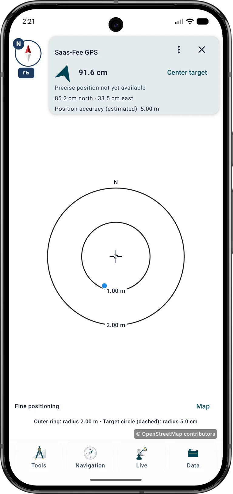
Open the target card's three-dot menu and select Precise point finding under Mode. Use Center target to restore the guided view. The crosshair marks the target and the blue dot your current position. North/south and east/west values describe movement from your position towards the target.
In guided precision mode, fine positioning appears automatically within 2 m of the target; beyond 3 m the map returns. Magnification follows distance and tolerance, with manual scale selection also available. It does not improve the position measurement. You can use this view with smartphone GPS, while the absence of RTK qualification remains visible.
Target navigation options → Mode: Precise point finding → Show precision view
Example: a target distance of 0.4 m with estimated position accuracy of 4 m does not mean you reached the physical spot within 40 cm. Distance is calculated between two coordinates; the current position and possibly the target are uncertain. Accuracy is an estimate, not a guaranteed maximum error.
Horizontal tolerance sets the permitted horizontal distance for qualified target evaluation. The outer ring describes only the visible scale. At a tolerance of 5 cm, the dashed target circle has a radius of 5 cm and a diameter of 10 cm. The ring's line width does not represent tolerance.
Android · Location.getAccuracy()
Target navigation stays active until you stop it manually. A proximity notice does not remove the target. After restarting the app, resume the saved target explicitly.
Select a point, open the target options and choose Precise point finding and a horizontal tolerance. The dial shows the receiver relative to the target; the north/south and east/west values show how to move towards it. You can choose north-up display, scale and optional signals.
A positive precision status requires RTK Fixed, fresh positions and corrections, and a suitable horizontal estimate over several distinct epochs. It refers to the entered coordinate. Check the target source, reference frame and antenna setup; distance and uncertainty are separate values.
Start RTK point measurement to save a result. Save a new measurement marker or attach a report to a linked point while retaining its coordinate. Explicitly allowed measurements outside tolerance are deviation reports. Native project files retain the report; navigation remains active.
Search on site and document the result
- Before setting out, record the point identifier, selected position type, marker code, source date and available accuracy information. Check the file import and background coverage while connected.
- Navigate towards the chosen point. Observe the reported GNSS accuracy, reception conditions and target distance. A distance display near zero means proximity to the stored coordinate within the measurement uncertainty; it does not identify a particular stone.
- At the location compare the recorded marker type with visible objects and surrounding features. A plastic marker may look different from a stone, and a documented marker may be covered, missing or altered. Do not treat a nearby unlabelled stone as a confirmed match.
- Respect access restrictions. Leave markers in place and do not alter them. For a legally binding boundary determination or an unclear identification, contact the responsible surveying authority or a qualified surveyor.
- Document an overview of the surroundings, a close-up of the visible marker and an app screenshot showing the selected target and reported positioning accuracy. Record the date and describe observations separately from assumptions about identity.
An observed marker, an ALKIS record and a measured phone or RTK position are separate pieces of evidence. Even a precise receiver does not improve the source coordinate retrospectively or establish the legal boundary by itself.