
Back up and restore MapTools
Choose the right backup, include the required files and attachments, save it outside the app and check the restore before changing devices.
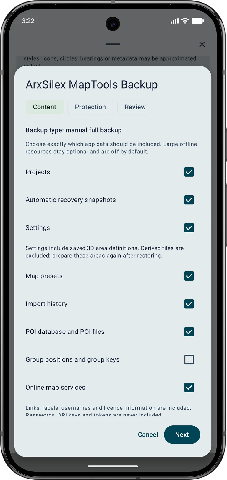
The screenshots show the English app interface. Content sizes are examples and depend on your saved data. Tap an image to enlarge it.
1. Choose the right kind of backup
An app backup collects the selected app data and resources. A native project export is useful for an individual project or selected objects. GPX, KML, GeoJSON, CSV and PDF serve exchange or reporting workflows and do not preserve every MapTools property or attachment.
Automatic recovery snapshots protect ongoing project work locally. They are not an independent copy if the device is lost, reset or damaged. Before changing devices or deleting originals, keep a manual backup in another location and check that you can open it.
2. Select the app backup contents
Data → Data Center → Backup & restore → Create app backup
Open the Data menu, then Data Center. In Backup & restore, choose Create app backup. In the content step, select the categories you need, such as projects, settings, map presets, recovery snapshots and POI data.
Scroll through the complete selection. Offline maps, layers, terrain and map styles are separate options; selecting a map preset does not automatically include its source files. Large resources can make the archive much bigger. Check the selected categories against what you will need offline on the destination device.
3. Protect and save the archive
In the protection step, decide whether to encrypt the backup. If you enable encryption, enter and confirm the password and keep it separately from the archive. Without that password, the encrypted backup cannot be restored.
In the review step, inspect the contents, total size, available space and warnings. Then create the backup and choose the destination in Android's file picker. Keep the app open for large archives. Retain a copy away from the phone, for example on your computer or an external drive.
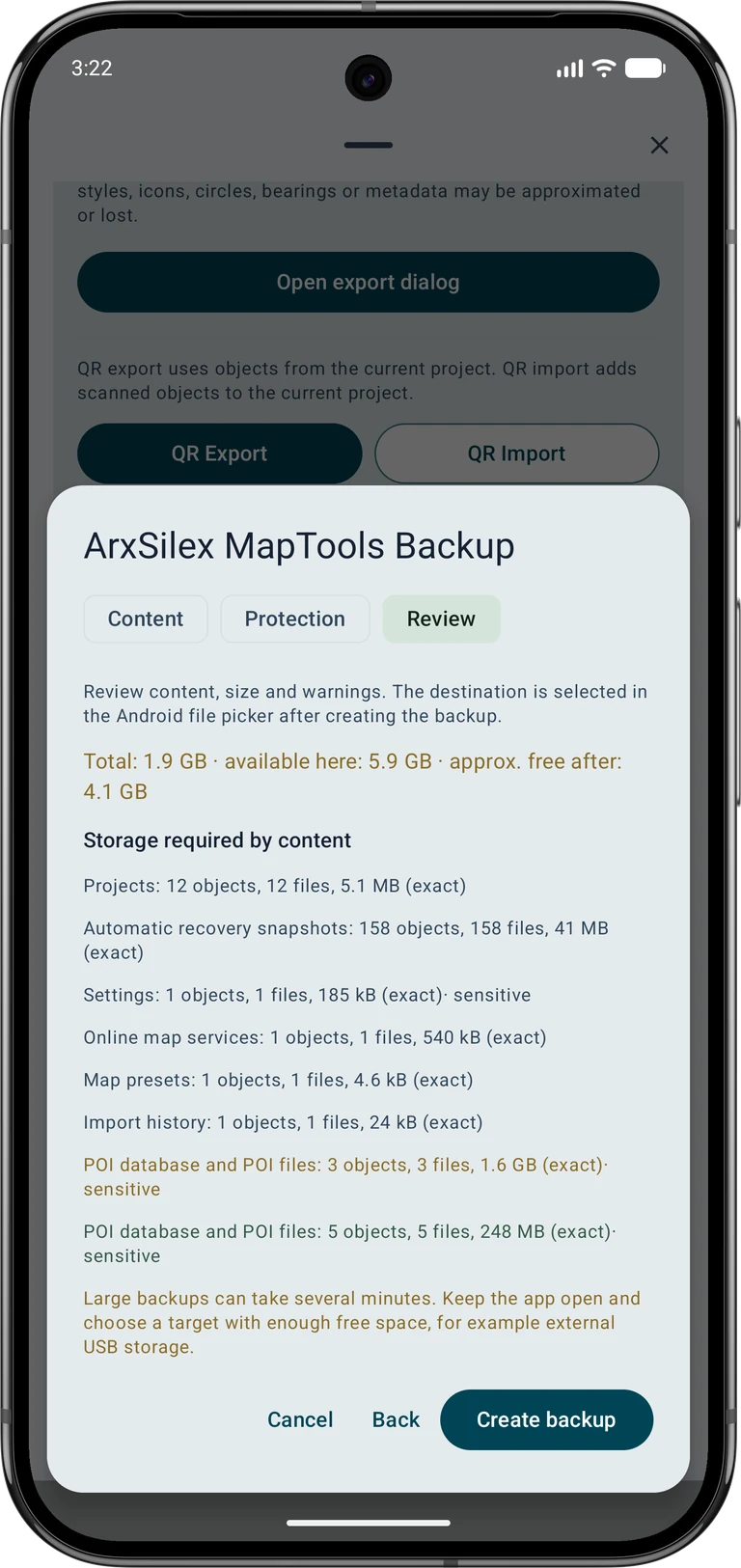
4. Preserve project photos and audio
For a project export, open the export dialog and choose the native ASMAPS format. Select all required objects, including separate photo and audio markers, and explicitly include object attachments. Exporting a route alone does not automatically include a separate photo marker.
Review the included and excluded attachment counts and sizes. A selected attachment whose original file is missing causes an export error; find the original or adjust the selection. After a trial import, open representative photos and audio files rather than checking only the number of objects.
5. Review the restore before applying it
Data → Data Center → Backup & restore → Restore app backup
Project data goes into a separate project. Settings and map resources included in the backup can still affect the whole app.
In Backup & restore, choose Restore app backup and select the archive. Enter its password if required. Read the summary and warnings. Choose Import as new project, Import selected content or Replace current project deliberately; back up the destination first if you might replace existing content.
Resolve any reported conflicts and inspect the final review before confirming. Importing as a new project does not mean that every other content category is automatically isolated. Check the scope of settings and resources too. If an archive is unsupported or a selected resource is missing, keep the source file and resolve the warning instead of deleting your existing data.
6. Check the restored data
Open the restored project and check representative objects, coordinates, photos and audio. Verify the required maps, layers, terrain and styles offline. Saved 3D area definitions can be included with settings; derived tiles are excluded and the areas must be prepared again.
GNSS recordings and RINEX files need their own exports; receiver profiles remain local. Online map service passwords, API keys and tokens are excluded from backups. Additional certificate trust and local HTTPS permission must be configured deliberately on the destination device. Check these connections before relying on them in the field. Keep the original backup until the restored workflow works as expected. See Free / Pro for project and backup limits.