Local, não na nuvem
Os dados off-line importados são armazenados no armazenamento do aplicativo ou em um local de arquivo de sua escolha. Não há sincronização em nuvem ArxSilex para mapas, POI, terreno ou projetos.
Off-line
Prepare mapas, POI, modelos de elevação, sobreposições raster e estilos para usar o ArxSilex MapTools sem cobertura móvel.
Atualizado: 8 de setembro de 2026
Centro de dados
Gira separadamente mapas, camadas vetoriais, sobreposições raster, dados de altitude, estilos de mapa e dados POI.
Os dados off-line importados são armazenados no armazenamento do aplicativo ou em um local de arquivo de sua escolha. Não há sincronização em nuvem ArxSilex para mapas, POI, terreno ou projetos.
O aplicativo usa o seletor de arquivos Android. Você seleciona arquivos deliberadamente; ArxSilex MapTools não solicita amplo acesso de armazenamento para todo o dispositivo.
O Smart Import analisa arquivos por conteúdo e sugere um alvo: mapa base, camada, sobreposição raster, POI, terreno, tema de renderização ou projeto.
Os mapas online podem pedir blocos a fornecedores de mapas externos. Utilize mapas, POIs e dados de terreno importados se pretender manter esta vista local.
Uma predefinição de mapa guarda as quatro posições de mapa, a sua ordem e a posição ativa, incluindo fontes, estilos, camadas, terreno, sobreposições, preferências de cálculo de rotas e visibilidade dos objetos do mapa. O perfil de interface, coordenadas, cores, ícones favoritos e ordem dos menus permanecem definições globais.
OpenAndroMaps, OpenStreetMap, seus próprios dados GIS, mapas de autoridade ou dados comerciais podem ter seus próprios termos de licença. O aplicativo não agrupa automaticamente dados de mapas externos.
Termos de utilização
ArxSilex MapTools usa esses termos deliberadamente. Eles deixam claro se um arquivo é usado como mapa base, geometria editável, sobreposição de imagem ou fonte de dados de elevação.
| Prazo | Definição curta | Exemplos |
|---|---|---|
| Mapas | Mapas básicos usados como visualização de trabalho principal. | OpenStreetMap, OpenAndroMaps, .map offline, MBTiles como mapa base |
| Camadas vetoriais | Dados adicionais de objeto, linha ou polígono acima do mapa. O conteúdo consiste em pontos, linhas ou áreas e muitas vezes pode ser exibido ou avaliado individualmente. | GPX, KML, GeoJSON, Formas, polígonos KML, áreas GeoJSON, faixas GPX como sobreposições |
| Sobreposições rasterizadas | Imagem georreferenciada ou dados de bloco acima do mapa. Eles são colocados como uma superfície de imagem acabada e não são interpretados como objetos individuais. | GeoTIFF, MBTiles, mapas de imagem, imagens aéreas, mapas digitalizados, planos georreferenciados |
| Dados de elevação/terreno | Fontes de dados para valores de elevação e análise de terreno. Eles não são um mapa visível no sentido estrito, mas fornecem informações de altura. | HGT, DEM GeoTIFF, ASC, DTED |
| Estilo do mapa | Regras de renderização para mapas vetoriais. O estilo define cores, símbolos, caminhos, POIs, linhas de contorno e outros elementos do mapa. | Tema de renderização OpenAndroMaps, Tema Elevar |
| Dados POI | Pesquise e exiba dados de locais e pontos de interesse. | OpenAndroMaps .poi, arquivos POI personalizados |
As camadas vetoriais contêm geometrias individuais. Eles são úteis para planejar dados, limites, áreas de pesquisa, rotas, trilhas e informações importadas do projeto.
As sobreposições raster são superfícies de imagem acabadas acima do mapa. Eles são úteis para imagens aéreas, mapas históricos, varreduras ou visualizações de mapas especiais. A opacidade é frequentemente ajustada para que o mapa base permaneça visível abaixo.
Mapas, camadas vetoriais e sobreposições raster podem ser mostrados no mapa. Os dados de elevação são geralmente usados por ferramentas: elevação de ponto, perfil de elevação, sombreamento, curvas de nível e alcance de visão.
Fontes
O ArxSilex MapTools não inclui dados cartográficos de terceiros. Descarregue os ficheiros do fornecedor adequado, verifique licença e formato e importe-os conscientemente na app.
| Tipo de dados | Fontes adequadas | Notas |
|---|---|---|
| Mapas base offline | OpenAndroMaps Mapas Gerais OpenAndroMaps Países e Regiões Exemplos: Alemanha, EEuropa, USA, América do Sul e Central, Canadá, Austrália, Nova Zelândia, Oceania, AÁsia e Oriente Médio, Rússia, AÁfrica | Para OpenAndroMaps, escolha um mapa mundial, nacional ou regional na página de origem. Importe arquivos ZIP com Karte_Map no nome como Map/Custom; importe POI_Normal...poi.zip como POI. |
| POI, camadas e dados OSM/GIS | BBBike Extracts Geofabrik Transferirs | BBBike e Geofabrik fornecem extratos OSM e formatos GIS como GeoJSON, Shapefile ou GeoPackage. Nem todo formato bruto é diretamente um mapa de aplicativo; importar apenas formatos suportados. Para Geofabrik, o formato de aplicativo relevante geralmente é .gpkg.zip quando um download de GeoPackage está disponível para a região selecionada. |
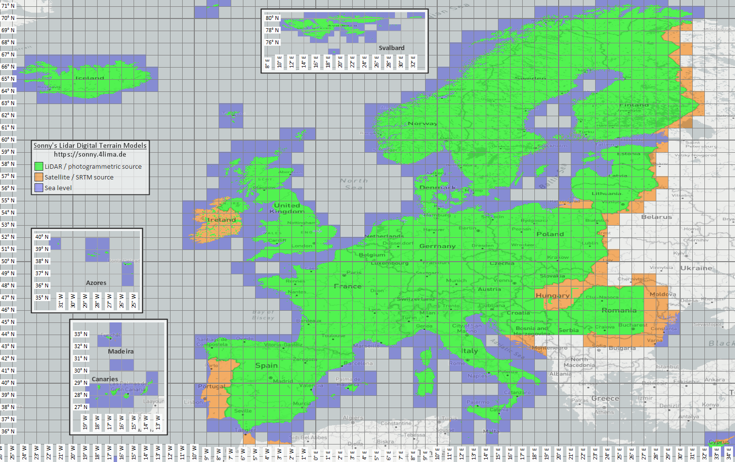
| Dados de elevação e terreno | Sonny LiDAR DTM Sonny DTM mapa geral USGS SRTM Topografia aberta Espaço de dados Copernicus | Sonny fornece modelos digitais de terreno europeus como fonte de dados de elevação. DTM 1" e DTM 3" são grades em segundos de arco, aproximadamente 30 me 90 m no equador; O DTM 20m e o DTM 50m indicam o espaçamento da grade diretamente em metros. Uma resolução mais precisa requer mais armazenamento e tempo de importação. Use o mapa geral para encontrar a coordenada/região correspondente e selecione-a na página de origem. |
| Sobreposições raster e mapas especiais | Portais de dados abertos | Portais oficiais, open data ou projetos GIS próprios podem fornecer GeoTIFF, KML/KMZ, MBTiles ou GeoPackage. Verifique georreferenciação e direitos antes de importar. |
| Temas de renderização | OpenAndroMaps Elevar | Use a página do tema OpenAndroMaps para o tema Elevar montanha/caminhada. Em Android, use a dica de instalação rápida para o aplicativo de mapas padrão ou baixe Elevate.zip e importe-o para ArxSilex MapTools como tema. |
| Licença e atualidade | - | As fontes podem exigir atribuição, registo, limites de uso ou ciclos próprios de atualização. A app não opera estes fornecedores nem substitui as suas licenças. |
Formatos
O aplicativo trata mapas, camadas vetoriais, sobreposições raster, dados POI, dados de elevação e estilos de mapa separadamente. O mesmo formato de arquivo pode ter destinos diferentes dependendo do seu conteúdo.
| Área | Suporteed data | Importante para uso |
|---|---|---|
| Mapas básicos off-line | Mapsforge .map, MBTiles .mbtiles, GeoPackage .gpkg | Os arquivos Mapsforge, por exemplo de OpenAndroMaps, destinam-se a mapas vetoriais. MBTiles e GeoPackage são usados como contêineres de blocos ou dados de catálogo de mapas. GeoTIFF não é um mapa base renderizável diretamente aqui. |
| Camadas vetoriais e sobreposições raster | GPX, GeoJSON, KML, KMZ, LOC, JSON, GeoPackage, GeoTIFF, Shapefile ZIP | Dados vetoriais e raster podem ser preparados como camadas adicionais. Visual GeoTIFF pertence a sobreposições raster; DEM GeoTIFF pertence aos dados de elevação. |
| POI e pesquisa off-line | .poi, .db, .sqlite, .geojson, .json, .csv, .tsv, .txt, .zip | POI pesquisável deve ser importado separadamente. Um arquivo de mapa off-line sozinho ainda não fornece uma pesquisa POI local completa. |
| Dados de elevação e análise de terreno | SRTM .hgt, DEM GeoTIFF .tif/.tiff/.geotiff, ESRI ASCII Grid .asc, DTED .dt0/.dt1/.dt2, GeoPackage .gpkg, ZIP de dados de elevação | Usado para altitude pontual, perfis de elevação, sombreado, curvas de nível e campo de visão. Dados de elevação GeoPackage compatíveis também podem ser usados como fonte de terreno. |
| Estilo do mapas | Arquivos ZIP de tema semelhante ao Mapsforge/Elevate compatíveis | O mapa e o estilo do mapa permanecem separados. Os temas externos devem ser obtidos separadamente e seguir licença própria. |
| Projetos e troca de dados | Projetos ArxSilex, GPX, KML, KMZ, GeoJSON, CSV, PDF, ZIP | Os formatos de projetos e trocas podem ser armazenados ou compartilhados offline. Os arquivos compartilhados saem do aplicativo somente por meio de sua ação. |
Preparação
Verifique qual região é realmente necessária. Conjuntos de dados menores e adequados iniciam mais rápido e economizam bateria e armazenamento.
Importe um arquivo Mapsforge .map, MBTiles ou um GeoPackage adequado. Em seguida, ative-o no perfil do mapa.
Se desejar uma pesquisa offline, importe os dados POI além do mapa e verifique categorias, tamanho e indexação.
Importe HGT, DEM GeoTIFF, ASC ou DTED para perfis de elevação, sombreamento, contornos e alcance de visão na área.
Use status offline, Camadas e Visibilidade e predefinições de mapa antes de entrar em uma área sem cobertura.
Limites
Os dados off-line são confiáveis, desde que a cobertura, o formato e a qualidade sejam adequados. Alguns recursos dependem intencionalmente de dados externos ou de ações do usuário.
Com um mapa vetorial Mapsforge compatível e ativo, o MapTools pode planear troços por caminhos utilizáveis. Se faltarem dados adequados, continua possível uma ligação direta ou livre. Rotas criadas ou importadas podem ser seguidas offline.
Os dados de elevação e POI funcionam apenas onde os arquivos importados realmente cobrem a área.
Os mapas online do Google ou OSM ainda podem solicitar blocos de fornecedores externos. Escolha mapas e dados importados para uso local.
Mapas grandes, GeoTIFFs, arquivos de dados de elevação e bancos de dados POI precisam de armazenamento e podem levar algum tempo para serem importados ou indexados.
Mapas importados, camadas vetoriais, sobreposições raster, dados POI, dados de elevação e estilos de mapa podem ser removidos nas áreas de dados relevantes. Os dados do aplicativo também podem ser apagados por meio de Android.
ArxSilex MapTools
A importação/exportação descreve os formatos de troca com mais detalhes. As permissões e a privacidade explicam quando arquivos, localização, mapas on-line ou terceiros são importantes.
Abrir importação e exportação Permissões abertas Privacidade aberta
Visão geral
A tabela liga a função ao formato, fonte, importação e ativação no MapTools. As fontes podem exigir registo, pagamento, atribuição ou outras condições de licença.
| Função | Dados necessários | Fontes adequadas | Importar na aplicação | Ativar e verificar |
|---|---|---|---|---|
| Mapa base offline | Mapsforge .map · Raster-MBTiles .mbtiles · GeoPackage .gpkg | OpenAndroMaps · Mapsforge | Abra Dados → Centro de dados → Importar dados. Verifique o destino do Smart Import; em alternativa ligue uma pasta. | Abra um slot de mapa, escolha a fonte e teste a cobertura. |
| POI e pesquisa offline | .poi · .db · .sqlite · GeoJSON · CSV/TSV/TXT | OpenAndroMaps · ficheiros POI próprios ou oficiais | Abra Dados → Centro de dados → Importar dados. Verifique o destino do Smart Import; em alternativa ligue uma pasta. | Escolha os POI no slot adequado; teste categorias, índice e pesquisa num local conhecido. |
| Altitudes, perfis, sombreado, curvas de nível e campo de visibilidade | HGT · DEM-GeoTIFF · ASC · DTED · GeoPackage .gpkg (DEM) | Sonny LiDAR DTM · USGS SRTM · OpenTopography · Copernicus | Abra Dados → Centro de dados → Importar dados. Verifique o destino do Smart Import; em alternativa ligue uma pasta. | Ative a fonte de terreno e teste uma altitude ou perfil dentro da cobertura. |
| Planeamento de rota e navegação offline | mapa Mapsforge .map compatível com caminhos utilizáveis | OpenAndroMaps · Mapsforge | Abra Dados → Centro de dados → Importar dados. Verifique o destino do Smart Import; em alternativa ligue uma pasta. | Escolha o mapa Mapsforge como fonte de routing e teste Seguir caminhos num troço curto. O mapa apresentado pode ser diferente. |
| Trajetos, rotas e pontos de passagem | GPX .gpx | gravações próprias · projetos exportados · portais de percursos segundo os seus termos | Importe GPX pelo Centro de dados, abra com MapTools ou partilhe com MapTools; verifique projeto e conteúdo detetado. | Mostre o conteúdo no navegador de objetos ou projeto e verifique no mapa. |
| Camadas SIG e vetoriais | GeoPackage · GeoJSON · Shapefile-ZIP · KML/KMZ | Geofabrik · BBBike · portais de dados abertos · entidades · dados SIG próprios | Abra Dados → Centro de dados → Importar dados. Verifique o destino do Smart Import; em alternativa ligue uma pasta. | Ative como camada vetorial no slot pretendido e verifique visibilidade e referência de coordenadas. |
| Sobreposições raster | GeoTIFF · Raster-MBTiles · KML/KMZ | portais de dados abertos · entidades · dados SIG próprios | Abra Dados → Centro de dados → Importar dados. Verifique o destino do Smart Import; em alternativa ligue uma pasta. | Ative como sobreposição raster; verifique posição, opacidade e escala. |
| Estilos de mapa | Mapsforge / Elevate · ZIP | OpenAndroMaps Elevate | Abra Dados → Centro de dados → Importar dados. Verifique o destino do Smart Import; em alternativa ligue uma pasta. | Atribua o estilo a um mapa Mapsforge compatível e verifique desenho e símbolos. |
| WMS, WMTS, XYZ/TMS, WFS e OGC API Features | HTTPS · GetCapabilities · URL · Auth | fornecedor do serviço; verificar acesso, custo e direitos | Configure o endpoint HTTPS no navegador de mapas em serviços online ou nos serviços de objetos. | Atribua o serviço guardado a um slot ou serviço de objetos. É necessária rede para consulta e FeatureInfo; não são ficheiros offline. |
| Azimutes, coordenadas, grelhas de busca e astronomia | nenhum ficheiro adicional; conforme a ferramenta: localização, sensores, hora e objetos de mapa existentes | MapTools e sensores do dispositivo; mapa base offline opcional para contexto | Não é necessária importação. Prepare separadamente mapa offline, objetos ou elevação quando necessário. | Nenhuma fonte adicional. Um mapa offline melhora a orientação; análises de terreno também precisam de elevação. |
Antes de trabalhar sem rede, ative o modo offline global e teste a área real: mapa visível, POI pesquisáveis, terreno ativo e camadas no slot correto.
Fluxo atual
O MapTools pode ligar coleções locais no dispositivo Android; o MapTools Converter opcional ajuda em preparações maiores no Windows ou Linux.
As pastas podem ser autorizadas para toda a aplicação ou por projeto através do seletor Android. O MapTools lista apenas os ficheiros diretamente contidos e nunca importa nem ativa algo automaticamente.
Mapas Mapsforge e fontes de terreno compatíveis podem ser ligados diretamente. Outros ficheiros são analisados deliberadamente e adicionados através do Smart Import.
A aplicação de computador separada inspeciona, recorta e combina mapas, POI e dados de elevação existentes e exporta ficheiros compatíveis com o MapTools. O processamento permanece local; os dados de origem e respetivos termos continuam a pertencer ao fornecedor.
Astronomia e dados offline
As horas astronómicas são calculadas offline a partir do local, data e fuso horário. Só é necessária uma fonte local de elevação quando o terreno real entra no resultado de visibilidade ou sombra.
Calendário Sol/Lua, nascer, pôr, crepúsculo, fase lunar e direções do Sol e da Lua não necessitam de DEM.
Horizonte do terreno, sombras em área do Sol ou Lua e análise de sombra da rota requerem dados HGT, DEM GeoTIFF, ASC ou DTED adequados e ativos.
Os dados devem cobrir o local ou rota e o possível obstáculo na direção do Sol ou Lua. Um DTM descreve o terreno; vegetação e edifícios requerem DSM. Resolução, idade e lacunas afetam o resultado.