
标记
 标记
标记标记在地图上放置单个点以查找结果、会面点、观察结果、检查点或保存的坐标。
手册
使用工具菜单中的标记、距离、方位、面积、圆和可见性工具。
工具菜单
工具菜单启动创建地图对象或准备测量的操作。许多工具首先询问来源:坐标、现有对象或您当前的 GPS 位置。
标记在地图上放置单个点以查找结果、会面点、观察结果、检查点或保存的坐标。
距离测量两点之间的线。选择第一个点,然后选择第二个点。
方位为航线、观察和目标缩小创建方向线。
Areas mark polygons for search zones, work areas, parcels, hazard zones or mapped terrain. 在 Pro 中,也可以从区域和圆形的详情中计算立柱和围栏估算。
圆围绕中心点绘制半径。菜单显示当前默认半径,例如 200 m。
可见性有助于描述某个点的相关视野或观察区域。
子菜单可以按常用工具排序,让符合自己流程的关键操作更容易访问。
标记、照片、备注和音频
打开“标记”选择位置。位置选项右侧有“照片”“备注”和“音频”。它们可创建带地理位置的标记,而不会长期占用主屏幕空间。
拍摄照片
仅在拍摄照片时需要相机权限。
要记录什么?
没有当前 GPS 位置。请选择备注放置位置。
录制语音备注
最长录制时间:10 分钟
打开“标记”选择位置。位置选项右侧有“照片”“备注”和“音频”。它们可创建带地理位置的标记,而不会长期占用主屏幕空间。
工具菜单
标记在地图上放置单个点以查找结果、会面点、观察结果、检查点或保存的坐标。
根据手动输入的坐标创建标记。
使用对象浏览器中的现有对象作为参考。
在当前 GPS 位置创建标记。
从多个 GPS 定位中可靠地确定标记,并在稍后的独立会话中重新测量它。
在固定准星下平移、缩放或旋转地图。坐标会跟随中心点;地图停止后,将显示活动地图槽位中可用的信息。
使用准星精确放置标记
准星模式补充了快速点按地图。地图在固定于屏幕的准星下移动,其地理中心将成为标记位置。
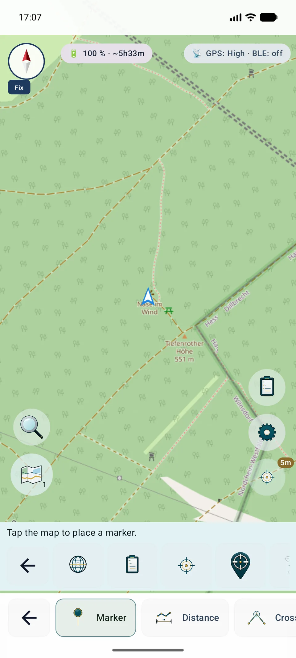
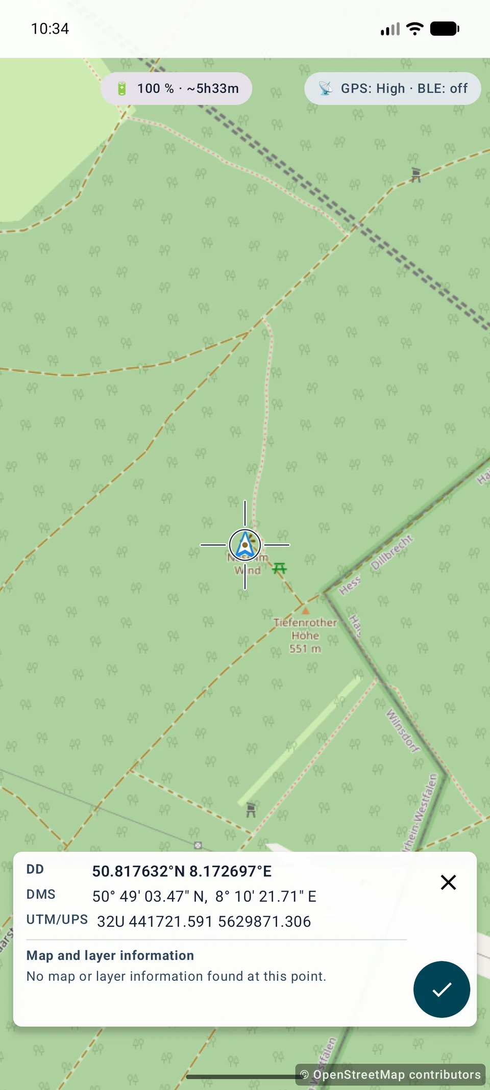
准星放置在 Free 中可用;只移动地图时不需要位置权限。地图对齐、数据源和缩放决定视觉精度。GPS 平均和重新测量仍为 Pro 功能。
地图中心的上下文
地图稳定后,面板会显示精确中心处可用信息的简短、受限预览。
DD、DMS、UTM 及其他所选格式各占一行。本地化的完整名称仍可供屏幕阅读器使用。
只查询活动地图槽位中的 Mapsforge,以及启用 InfoTap 的 OGC API Features、WFS、WMS 或 WMTS 图层。
只显示可查询的地图对象或 FeatureInfo。没有信息接口的 XYZ、TMS 和栅格源不会生成虚构属性。
勾号打开对话框;取消或返回会保留位置,X 会退出,成功保存只创建一个标记。
坐标和本地 Mapsforge 数据可离线使用。远程信息只通过现有受保护客户端向活动源请求。服务错误不会阻止标记放置。
工具菜单
距离测量两点之间的线。选择第一个点,然后选择第二个点。
选择坐标、现有对象或此处 (GPS)。
以同样的方式选择目标点。该应用程序绘制线条并显示距离。
将您的位置与标记、两个对象或两个坐标条目进行比较。
工具菜单
方位为航线、观察和目标缩小创建方向线。
定义在地图上绘制线条的距离。
直接使用当前的观察方向。
打开相机视图以视觉固定点并创建方位。
选择坐标起点并手动输入角度。
从对象浏览器中选择起点并手动输入角度。
从当前的 GPS 位置开始并手动输入方向。
工具菜单
Areas mark polygons for search zones, work areas, parcels, hazard zones or mapped terrain. 在 Pro 中,也可以从区域和圆形的详情中计算立柱和围栏估算。
从地图、坐标、对象或 GPS 添加多个折点。
该应用程序通过至少三个点创建一个具有轮廓和大小的区域。
管理对象浏览器中的区域,包括可见性、导出和删除。
打开区域或圆形的详情,以计算立柱间距、线股数量、估算围栏长度、立柱数量和线股长度。
工具菜单
圆围绕中心点绘制半径。菜单显示当前默认半径,例如 200 m。
选择坐标、对象或此处 (GPS)。
使用或调整搜索区域、范围和安全区域的半径。
圆圈使围绕一点的距离更容易判断。
手册
ViewRange计算360°完整圆形地形可视性,不选择单一方向。
启用HGT、DEM GeoTIFF、ASC或DTED。
选择1–10公里以及快速/标准/高。
高程覆盖不完整时结果也不完整;保存前请检查。
标记和测量
设备提供时,标记、区域点、方位和 ViewRange 可以保存并显示 GPS/RTK 质量数据。对于自由放置的标记,如果有活动高程数据,MapTools 会在保存时添加地形高程。标记位置也可以根据一系列位置测量求平均,使点位记录更容易复现。
MapTools
点可来自坐标、现有对象、GPS或标记十字线。图标与应用中的真实按钮一致;没有按钮的普通步骤不显示虚构图标。
CRS / EPSG
GeoJSON / KML / GPX
WGS84
圆形工具
先设置半径,再打开十字准星。在固定中心下移动地图时,所选半径仍会显示。点按对勾即可确认圆心,并打开常规编辑界面。按 X 或返回会关闭十字准星而不创建圆形;仍可直接点按地图。Google Maps 和 VTM 的操作相同。
详细指南
两项工具都有独立流程和页面。
测量A,移动后测量B,并检查基线、交角、质量和不确定性。
利用活动高程计算360°;方向不是设置项。
当前功能
地理数据搜索结合本地 POI 与已启用的 WFS、OGC 要素图层。可主动选择搜索、来源范围、类别和半径;“无半径”会移除距离过滤器。选中 POI 后会先打开紧凑操作视图,可查看地图、目标、标记和分享。
 距离
距离 方位
方位 领域
领域 圆
圆 能见度
能见度 坐标
坐标 对象
对象 这里 (GPS)
 GPS 平均位置
 使用准星定位