クラウドではなくローカル
インポートされたオフライン データは、アプリが所有するストレージまたは選択したファイルの場所に保存されます。マップ、POI、地形、またはプロジェクトに対する ArxSilex クラウド同期はありません。
オフライン
地図、POI、標高モデル、ラスターレイヤー、地図スタイルを準備し、通信圏外でも ArxSilex MapTools を使えるようにします。
更新日: 2026年9月8日
データセンター
地図、ベクターレイヤー、ラスターオーバーレイ、標高データ、地図スタイル、POIデータを個別に管理します。
インポートされたオフライン データは、アプリが所有するストレージまたは選択したファイルの場所に保存されます。マップ、POI、地形、またはプロジェクトに対する ArxSilex クラウド同期はありません。
アプリは Android ファイル ピッカーを使用します。ファイルは意図的に選択します。 ArxSilex MapTools は、デバイス全体への広範なストレージ アクセスを要求しません。
Smart Import はコンテンツごとにファイルを分析し、ベース マップ、レイヤー、ラスター オーバーレイ、POI、地形、レンダリング テーマ、プロジェクトなどのターゲットを提案します。
オンライン地図では、外部の地図提供元からタイルを取得する場合があります。この表示のデータをローカルに保つには、インポートした地図、POI、地形データを使用してください。
地図プリセットは4つの地図スロット、順序、使用中のスロットを保存します。地図ソース、スタイル、レイヤー、地形、オーバーレイ、経路探索の設定、地図オブジェクトの表示状態も含みます。画面プロファイル、座標、色、お気に入りのアイコン、メニューの順序は全体共通の設定です。
OpenAndroMaps、OpenStreetMap、独自の GIS データ、典拠図、商用データには、独自のライセンス条項がある場合があります。アプリは外部地図データを自動的にバンドルしません。
利用規約
ArxSilex MapTools はこれらの用語を意図的に使用しています。これらにより、ファイルがベース マップ、編集可能なジオメトリ、イメージ オーバーレイ、または標高データ ソースとして使用されているかどうかが明確になります。
| 期間 | 簡単な定義 | 例 |
|---|---|---|
| 地図 | メインの作業ビューとして使用されるベース マップ。 | OpenStreetMap、OpenAndroMaps、ベースマップとしてのオフライン .map、MBTiles |
| ベクターレイヤー | マップ上の追加のオブジェクト、ライン、またはポリゴン データ。コンテンツは点、線、または領域で構成され、多くの場合、個別に表示または評価できます。 | GPX、KML、GeoJSON、シェイプ、KML ポリゴン、GeoJSON エリア、オーバーレイとしての GPX トラック |
| ラスターオーバーレイ | 地図上の地理参照された画像またはタイル データ。これらは完成した画像面として配置され、個々のオブジェクトとして解釈されません。 | GeoTIFF、MBTiles、イメージ マップ、航空写真、スキャンされたマップ、地理参照された計画 |
| 標高データ・地形 | データソース 標高値と地形解析に使用されます。狭義の表示地図ではありませんが、高さ情報を提供します。 | HGT、DEM GeoTIFF、ASC、DTED |
| マップスタイル | ベクター マップのレンダリング ルール。このスタイルは、色、シンボル、パス、POI、等高線、その他の地図要素を定義します。 | OpenAndroMaps レンダリング テーマ、Elevate テーマ |
| POI データ | 場所や興味のあるポイントのデータを検索して表示します。 | OpenAndroMaps .poi、カスタム POI ファイル |
ベクターレイヤーには個別の形状が含まれます。計画データ、境界、検索エリア、ルート、トラック、インポートしたプロジェクト情報に役立ちます。
ラスターオーバーレイは地図上に重ねる完成済みの画像面です。航空写真、古地図、スキャン画像、特殊な地図表示に役立ちます。下のベースマップが見えるように不透明度を調整することがあります。
地図、ベクターレイヤー、ラスターオーバーレイは地図上に表示できます。標高データは通常、地点標高、標高プロファイル、陰影起伏、等高線、可視範囲などのツールで使われます。
入手先
ArxSilex MapTools には第三者の地図データは同梱されません。適切な提供元からファイルを入手し、ライセンスと形式を確認してからアプリに取り込みます。
| データ種別 | 適した入手先 | メモ |
|---|---|---|
| オフライン基本地図 | OpenAndroMaps 一般地図 OpenAndroMaps の国と地域 例: ドイツ、ヨーロッパ、アメリカ、南米および中米、カナダ、オーストラリア、ニュージーランド、オセアニア、 アジアおよび中東、ロシア、アフリカ | OpenAndroMaps の場合は、ソース ページで世界、国、または地域の地図を選択します。名前に Karte_Map を含む ZIP ファイルを Map/Custom としてインポートします。 POI_Normal...poi.zip を POI としてインポートします。 |
| POI、レイヤー、OSM/GIS データ | BBBike Extracts Geofabrik ダウンロードs | BBBike と Geofabrik は、OSM 抽出と GeoJSON、Shapefile、GeoPackage などの GIS 形式を提供します。すべての生の形式がそのままアプリ マップになるわけではありません。サポートされている形式のみをインポートします。 Geofabrik の場合、選択した地域で GeoPackage ダウンロードが利用可能な場合、関連するアプリ形式は通常 .gpkg.zip です。 |
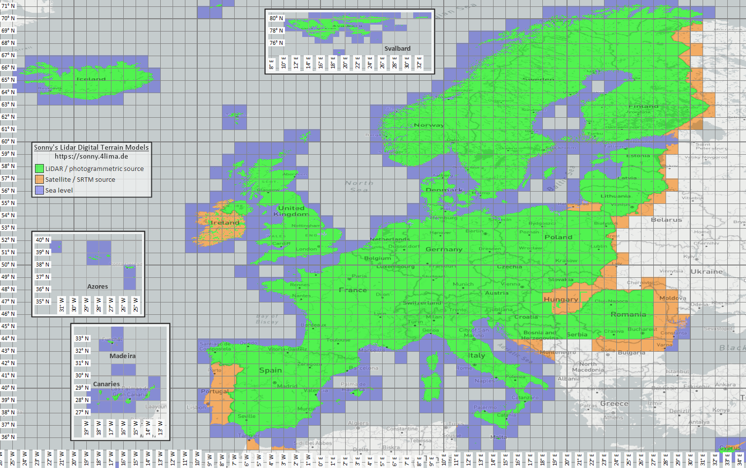
| 標高・地形データ | Sonny LiDAR DTM Sonny DTM 概要マップ USGS SRTM OpenTopography Copernicus データ スペース | Sonny は、標高データのソースとしてヨーロッパのデジタル地形モデルを提供しています。 DTM 1" と DTM 3" は、赤道でおおよそ約 30 m と 90 m の円弧秒単位のグリッドです。 DTM 20m および DTM 50m は、グリッド間隔をメートル単位で直接示します。解像度を高くすると、より多くのストレージとインポート時間が必要になります。概要マップを使用して一致する座標/地域を見つけ、ソース ページでそれを選択します。 |
| ラスターオーバーレイと特殊地図 | オープンデータポータル | 行政ポータル、オープンデータポータル、独自 GIS プロジェクトでは GeoTIFF、KML/KMZ、MBTiles、GeoPackage が提供されることがあります。取り込み前にジオリファレンスと利用条件を確認します。 |
| 描画テーマ | OpenAndroMaps Elevate | Elevate マウンテン/ハイキング テーマには、OpenAndroMaps テーマ ページを使用してください。 Android で、デフォルトのマップ アプリのクイック インストール ヒントを使用するか、Elevate.zip をダウンロードしてテーマとして ArxSilex MapTools にインポートします。 |
| ライセンスと更新 | - | 提供元は帰属表示、登録、利用制限、独自の更新周期を求める場合があります。アプリはこれらの提供元を運営せず、ライセンス文の代わりにもなりません。 |
フォーマット
このアプリは、地図、ベクター レイヤー、ラスター オーバーレイ、POI データ、標高データ、地図スタイルを個別に処理します。同じファイル形式でも、その内容に応じて異なるターゲットを持つことができます。
| エリア | サポートed data | 使用上の重要事項 |
|---|---|---|
| オフラインベースマップ | Mapsforge .map、MBTiles .mbtiles、GeoPackage .gpkg | OpenAndroMaps などの Mapsforge ファイルは、ベクトル マップ用です。 MBTiles および GeoPackage は、タイル コンテナーまたはマップ カタログ データとして使用されます。 GeoTIFF は、ここでは直接レンダリング可能なベース マップではありません。 |
| ベクターレイヤーとラスターオーバーレイ | GPX、GeoJSON、KML、KMZ、LOC、JSON、GeoPackage、GeoTIFF、シェープファイル ZIP | 追加レイヤーとしてベクターデータとラスターデータを用意できます。 Visual GeoTIFF はラスター オーバーレイに属します。 DEM GeoTIFF は標高データに属します。 |
| POI とオフライン検索 | .poi、.db、.sqlite、.geojson、.json、.csv、.tsv、.txt、.zip | 検索可能な POI は個別にインポートする必要があります。オフライン マップ ファイルだけでは、完全なローカル POI 検索はまだ提供されていません。 |
| 標高データと地形解析 | SRTM .hgt、DEM GeoTIFF .tif/.tiff/.geotiff、ESRI ASCII Grid .asc、DTED .dt0/.dt1/.dt2、GeoPackage .gpkg、標高データZIP | 地点標高、ルート標高プロファイル、陰影、等高線、可視範囲に使用します。対応するGeoPackage標高データも地形ソースとして使用できます。 |
| マップスタイルs | 互換性のある Mapsforge/Elevate のようなテーマ ZIP ファイル | マップとマップ スタイルは分離されたままになります。外部テーマは別途取得し、独自のライセンスに従う必要があります。 |
| プロジェクトとデータ交換 | ArxSilex プロジェクト、GPX、KML、KMZ、GeoJSON、CSV、PDF、ZIP | プロジェクトおよび交換フォーマットはオフラインで保存または共有できます。共有ファイルは、ユーザーのアクションによってのみアプリから削除されます。 |
準備
本当に必要な地域を確認してください。小さくて適切なデータセットは起動が速く、バッテリーとストレージを節約します。
Mapsforge .map ファイル、MBTiles、または適切な GeoPackage をインポートします。次に、地図プリセットでそれを有効にします。
オフライン検索が必要な場合は、マップに加えて POI データをインポートし、カテゴリ、サイズ、インデックスを確認します。
エリア内の標高プロファイル、陰影起伏、等高線、および表示範囲については、HGT、DEM GeoTIFF、ASC、または DTED をインポートします。
カバレッジのないエリアに入る前に、オフライン ステータス、レイヤーと表示設定、および地図プリセットを使用してください。
限界
オフライン データは、カバレッジ、形式、品質が適合している限り信頼できます。一部の機能は外部データまたはユーザーのアクションに意図的に依存します。
互換Mapsforgeベクター地図が有効なら、MapToolsは利用可能な道に沿って区間を計画できます。適切な道がない場合も直線または自由接続が可能です。作成・インポートしたルートはオフラインで追跡できます。
標高データと POI は、インポートされたファイルが実際にエリアをカバーする場所でのみ機能します。
Google または OSM オンライン マップは引き続き外部プロバイダーにタイルをリクエストできます。ローカルで使用するためにインポートされたマップとデータを選択します。
大規模なマップ、GeoTIFF、標高データ アーカイブ、POI データベースにはストレージが必要で、インポートやインデックス作成に時間がかかる場合があります。
インポートされたマップ、ベクター レイヤー、ラスター オーバーレイ、POI データ、標高データ、およびマップ スタイルは、関連するデータ領域で削除できます。アプリデータは、Android を通じてクリアすることもできます。
ArxSilex MapTools
インポート/エクスポートでは、交換フォーマットについて詳しく説明します。アクセス許可とプライバシーは、ファイル、場所、オンライン マップ、またはサードパーティがどのような場合に重要であるかを説明します。
一覧
この表では、使いたい機能からファイル形式、入手先、MapToolsへのインポート、有効化までをまとめています。提供元によって登録、料金、表示義務、追加ライセンス条件があります。
| 機能 | 必要なデータ | 入手先 | アプリへのインポート | 有効化と確認 |
|---|---|---|---|---|
| オフライン基本地図 | Mapsforge .map · Raster-MBTiles .mbtiles · GeoPackage .gpkg | OpenAndroMaps · Mapsforge | データ → データセンター → データをインポートを開きます。Smart Importの対象を確認するか、データフォルダーを連携します。 | マップスロットを開き、提供元を選択して範囲を確認します。 |
| POIとオフライン検索 | .poi · .db · .sqlite · GeoJSON · CSV/TSV/TXT | OpenAndroMaps · 自作または公的POIファイル | データ → データセンター → データをインポートを開きます。Smart Importの対象を確認するか、データフォルダーを連携します。 | 適切なスロットでPOIを選択し、既知の場所でカテゴリ、索引、検索を確認します。 |
| 標高、プロファイル、陰影、等高線、可視範囲 | HGT · DEM-GeoTIFF · ASC · DTED · GeoPackage .gpkg (DEM) | Sonny LiDAR DTM · USGS SRTM · OpenTopography · Copernicus | データ → データセンター → データをインポートを開きます。Smart Importの対象を確認するか、データフォルダーを連携します。 | 地形データを有効化し、範囲内の地点標高またはプロファイルを確認します。 |
| オフライン経路計画とナビゲーション | 利用可能な道路データを含む互換Mapsforge .map | OpenAndroMaps · Mapsforge | データ → データセンター → データをインポートを開きます。Smart Importの対象を確認するか、データフォルダーを連携します。 | Mapsforge地図をルーティング元に選び、短区間で「道に沿う」を試します。表示地図とルーティング元は別でも構いません。 |
| トラック、ルート、ウェイポイント | GPX .gpx | 自分の記録 · 書き出したプロジェクト · 各利用条件に従うルート提供サイト | データセンターでGPXをインポートするか、MapToolsで開く/共有します。対象プロジェクトと検出内容を確認します。 | オブジェクトブラウザーまたはプロジェクトで表示し、地図上で確認します。 |
| GIS・ベクターレイヤー | GeoPackage · GeoJSON · Shapefile-ZIP · KML/KMZ | Geofabrik · BBBike · オープンデータポータル · 行政機関 · 自分のGISデータ | データ → データセンター → データをインポートを開きます。Smart Importの対象を確認するか、データフォルダーを連携します。 | 目的のスロットでベクターレイヤーとして有効化し、表示と座標参照を確認します。 |
| ラスターオーバーレイ | GeoTIFF · Raster-MBTiles · KML/KMZ | オープンデータポータル · 行政機関 · 自分のGISデータ | データ → データセンター → データをインポートを開きます。Smart Importの対象を確認するか、データフォルダーを連携します。 | ラスターオーバーレイとして有効化し、位置、透明度、縮尺を確認します。 |
| 地図スタイル | Mapsforge / Elevate · ZIP | OpenAndroMaps Elevate | データ → データセンター → データをインポートを開きます。Smart Importの対象を確認するか、データフォルダーを連携します。 | 互換Mapsforge地図にスタイルを割り当て、描画と記号を確認します。 |
| WMS、WMTS、XYZ/TMS、WFS、OGC API Features | HTTPS · GetCapabilities · URL · Auth | 各サービス提供者。アクセス、料金、利用権を確認 | マップブラウザーのオンライン地図サービスまたはオブジェクトサービスでHTTPSエンドポイントを設定します。 | 保存したサービスをスロットまたはオブジェクトサービスに割り当てます。取得とFeatureInfoには通信が必要で、オフラインファイルではありません。 |
| 方位、座標、捜索グリッド、天文 | 追加ファイル不要。機能により位置、端末センサー、時刻、既存の地図オブジェクトを使用 | MapToolsと端末センサー。地図上の参照にはオフライン基本地図を任意で使用 | データのインポートは不要です。必要に応じてオフライン地図、オブジェクト、標高データを別途準備します。 | 追加のデータ元はありません。オフライン地図は把握を助け、地形依存の解析には標高データも必要です。 |
圏外で使う前にグローバルオフラインモードを有効にし、実際の地域で地図、POI、地形、正しいスロットのレイヤーを確認してください。
現在のワークフロー
MapToolsはAndroid端末上のローカルコレクションを接続できます。任意のMapTools ConverterはWindowsまたはLinuxでの大規模な準備を支援します。
Androidのフォルダー選択で、アプリ全体またはプロジェクト単位のアクセスを許可できます。MapToolsは直下のファイルだけを表示し、自動的なインポートや有効化は行いません。
対応するMapsforge地図と地形ソースは直接リンクできます。その他のファイルは確認してからSmart Importで追加します。
独立したデスクトップアプリで、既存の地図、POI、標高データを確認、切り出し、結合し、MapTools対応ファイルを出力できます。処理はローカルで行われ、ソースデータと利用条件は各提供者のものです。
天文機能とオフラインデータ
天文時刻は場所、日付、タイムゾーンからオフライン計算されます。実地形を視認性や影の結果に含める場合だけ、ローカル標高源が必要です。
太陽/月カレンダー、出没、薄明、月相、太陽と月の方向にはDEMは不要です。
地形地平線、太陽または月の面的な影、ルート日陰解析には、有効なHGT、DEM GeoTIFF、ASC、DTEDが必要です。
場所やルートに加え、太陽・月方向の障害候補もデータ範囲に含めます。DTMは地形、植生や建物はDSMが必要です。解像度、古さ、欠損が結果に影響します。