Local, nu cloud
Datele offline importate sunt stocate în spațiul de stocare deținut de aplicație sau într-o locație a fișierului pe care o alegeți. Nu există sincronizare în cloud ArxSilex pentru hărți, POI, teren sau proiecte.
Offline
Pregătiți hărți, POI, modele de elevație, suprapuneri raster și stiluri de hartă pentru folosire fără acoperire mobilă.
Actualizat: 8 septembrie 2026
Centru de date
Gestionează separat hărțile, straturile vectoriale, suprapunerile raster, datele de altitudine, stilurile hărților și datele POI.
Datele offline importate sunt stocate în spațiul de stocare deținut de aplicație sau într-o locație a fișierului pe care o alegeți. Nu există sincronizare în cloud ArxSilex pentru hărți, POI, teren sau proiecte.
Aplicația folosește selectorul de fișiere Android. Selectați fișierele în mod deliberat; ArxSilex MapTools nu solicită acces larg de stocare la întregul dispozitiv.
Smart Import analizează fișierele după conținut și sugerează o țintă: hartă de bază, strat, suprapunere raster, POI, teren, temă de randare sau proiect.
Hărțile online pot solicita dale de la furnizori externi de hărți. Folosește hărți, POI-uri și date de relief importate dacă vrei ca această vizualizare să rămână locală.
O configurație de hartă salvează toate cele patru sloturi, ordinea lor și slotul activ, inclusiv sursele de hartă, stilurile, straturile, relieful, suprapunerile, preferințele de calcul al rutelor și vizibilitatea obiectelor de hartă. Profilul interfeței, coordonatele, culorile, pictogramele favorite și ordinea meniurilor rămân setări globale.
OpenAndroMaps, OpenStreetMap, propriile dvs. date GIS, hărțile autorităților sau datele comerciale pot avea propriii termeni de licență. Aplicația nu grupează automat date externe ale hărții.
Termeni de utilizare
ArxSilex MapTools folosește acești termeni în mod deliberat. Ele indică clar dacă un fișier este utilizat ca hartă de bază, geometrie editabilă, suprapunere de imagini sau sursă de date de altitudine.
| Termen | Scurtă definiție | Exemple |
|---|---|---|
| Hărți | Hărți de bază utilizate ca vedere de lucru principală. | OpenStreetMap, OpenAndroMaps, offline .map, MBTiles ca hartă de bază |
| Straturi vectoriale | Date suplimentare despre obiecte, linii sau poligon deasupra hărții. Conținutul constă din puncte, linii sau zone și poate fi adesea afișat sau evaluat individual. | GPX, KML, GeoJSON, Forme, KML poligoane, GeoJSON zone, GPX piste ca suprapuneri |
| Suprapuneri raster | Imagine georeferențiată sau date din piese deasupra hărții. Ele sunt plasate ca o suprafață de imagine finită și nu sunt interpretate ca obiecte individuale. | GeoTIFF, MBTiles, hărți imagine, imagini aeriene, hărți scanate, planuri georeferențiate |
| Date de altitudine / teren | Surse de date pentru valori de altitudine și analiză a terenului. Nu sunt o hartă vizibilă în sens strict, dar furnizează informații de înălțime. | HGT, DEM GeoTIFF, ASC, DTED |
| Stil hartă | Reguli de randare pentru hărți vectoriale. Stilul definește culorile, simbolurile, căile, POI-urile, liniile de contur și alte elemente ale hărții. | Tema de randare OpenAndroMaps, tema Elevate |
| Date POI | Căutați și afișați date pentru locuri și puncte de interes. | OpenAndroMaps .poi, fișiere personalizate POI |
Straturile vectoriale conțin geometrii individuale. Sunt utile pentru date de planificare, limite, zone de căutare, rute, trackuri și informații de proiect importate.
Suprapunerile raster sunt suprafețe de imagine finalizate deasupra hărții. Sunt utile pentru imagini aeriene, hărți istorice, scanări sau vizualizări speciale de hartă. Opacitatea este adesea ajustată pentru ca harta de bază să rămână vizibilă dedesubt.
Hărțile, straturile vectoriale și suprapunerile raster pot fi afișate pe hartă. Datele de altitudine sunt folosite de obicei de instrumente: altitudine punct, profil de altitudine, umbrire relief, curbe de nivel și rază vizuală.
Surse
ArxSilex MapTools nu include date cartografice terțe. Descărcați fișierele de la furnizorul potrivit, verificați licența și formatul, apoi importați-le deliberat în aplicație.
| Tip de date | Surse potrivite | Notă |
|---|---|---|
| Hărți de bază offline | Hărți generale OpenAndroMaps Țări și regiuni OpenAndroMaps Exemple: Germania, Europa, STATELE UNITE ALE AMERICII, America de Sud și de Mijloc, Canada, Australia, Noua Zeelandă, Oceania, Asia și Orientul Mijlociu, Rusia, Africa | Pentru OpenAndroMaps, alegeți o hartă a lumii, țării sau regionale pe pagina sursă. Importați fișiere ZIP cu Karte_Map cu numele Map/Custom; importați POI_Normal...poi.zip ca POI. |
| POI, straturi și date OSM/GIS | BBBike Extracts Geofabrik Descărcares | BBBike și Geofabrik furnizează extrase OSM și formate GIS, cum ar fi GeoJSON, Shapefile sau GeoPackage. Nu orice format brut este direct o hartă a aplicației; importați numai formatele acceptate. Pentru Geofabrik, formatul relevant de aplicație este de obicei .gpkg.zip atunci când o descărcare GeoPackage este disponibilă pentru regiunea selectată. |
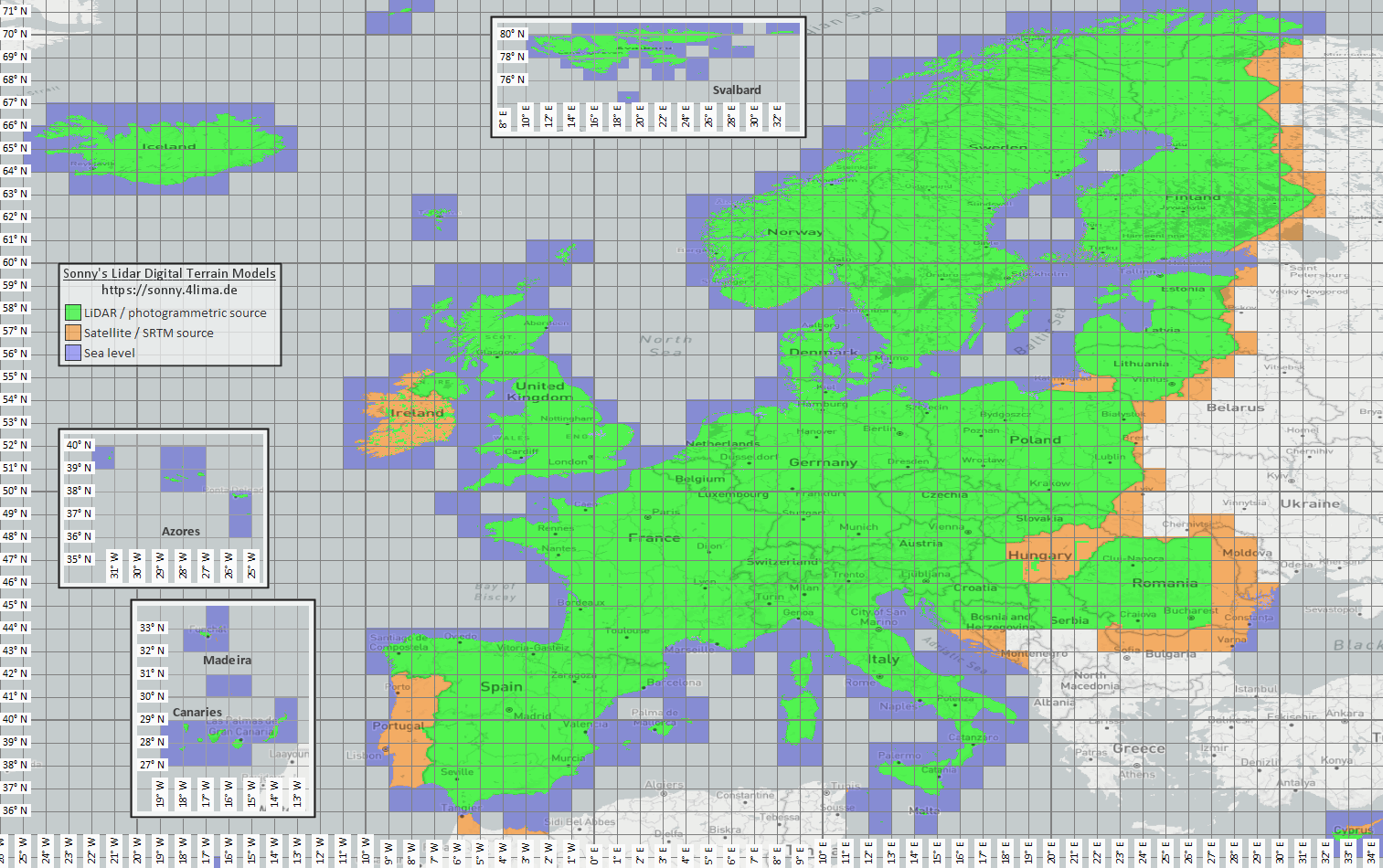
| Date de elevație și teren | Sonny LiDAR DTM Sonny DTM hartă generală USGS SRTM OpenTopography Copernicus Data Space | Sonny oferă modele digitale europene de teren ca sursă pentru date de altitudine. DTM 1" și DTM 3" sunt grile în secunde de arc, aproximativ 30 m și 90 m la ecuator; DTM 20m și DTM 50m indică distanța dintre grile direct în metri. O rezoluție mai fină necesită mai mult timp de stocare și de import. Utilizați harta generală pentru a găsi coordonatele/regiunea potrivite, apoi selectați-o pe pagina sursă. |
| Suprapuneri raster și hărți speciale | Portaluri de date deschise | Portalurile oficiale, open-data sau proiectele GIS proprii pot oferi GeoTIFF, KML/KMZ, MBTiles sau GeoPackage. Verificați georeferențierea și drepturile înainte de import. |
| Teme de randare | OpenAndroMaps Elevate | Utilizați pagina cu tema OpenAndroMaps pentru tema Elevate munte/excursie. Pe Android, utilizați indicația de instalare rapidă pentru aplicația de hărți implicită sau descărcați Elevate.zip și importați-l în ArxSilex MapTools ca temă. |
| Licență și actualitate | - | Sursele pot cere atribuire, înregistrare, limite de utilizare sau pot avea propriul ritm de actualizare. Aplicația nu operează acești furnizori și nu înlocuiește licențele lor. |
Formate
Aplicația tratează separat hărțile, straturile vectoriale, suprapunerile raster, datele POI, datele de altitudine și stilurile de hartă. Același format de fișier poate avea ținte diferite în funcție de conținutul său.
| Suprafață | Suported data | Important pentru utilizare |
|---|---|---|
| Hărți de bază offline | Mapsforge .map, MBTiles .mbtile, GeoPackage .gpkg | Fișierele Mapsforge, de exemplu de la OpenAndroMaps, sunt destinate hărților vectoriale. MBTiles și GeoPackage sunt folosite ca containere de plăci sau date de catalog de hărți. GeoTIFF nu este o hartă de bază care poate fi redată direct aici. |
| Straturi vectoriale și suprapuneri raster | GPX, GeoJSON, KML, KMZ, LOC, JSON, GeoPackage, GeoTIFF, Shapefile ZIP | Datele vectoriale și raster pot fi pregătite ca straturi suplimentare. Visual GeoTIFF aparține suprapunerilor raster; DEM GeoTIFF aparține datelor de altitudine. |
| POI și căutare offline | .poi, .db, .sqlite, .geojson, .json, .csv, .tsv, .txt, .zip | POI care poate fi căutat trebuie importat separat. Numai un fișier de hartă offline nu oferă încă o căutare locală completă POI. |
| Date de altitudine și analiza terenului | SRTM .hgt, DEM GeoTIFF .tif/.tiff/.geotiff, ESRI ASCII Grid .asc, DTED .dt0/.dt1/.dt2, GeoPackage .gpkg, ZIP cu date de altitudine | Folosit pentru altitudinea punctelor, profile, umbrire, curbe de nivel și raza vizuală. Datele de altitudine GeoPackage acceptate pot fi folosite și ca sursă de teren. |
| Stil hartăs | Fișierele ZIP compatibile cu tema Mapsforge/Elevate | Harta și stilul hărții rămân separate. Temele externe trebuie să fie obținute separat și să urmeze propria licență. |
| Proiecte și schimb de date | Proiecte ArxSilex, GPX, KML, KMZ, GeoJSON, CSV, PDF, ZIP | Formatele de proiect și de schimb pot fi stocate sau partajate offline. Fișierele partajate părăsesc aplicația numai prin acțiunea dvs. |
Pregătirea
Verificați care regiune este cu adevărat necesară. Seturile de date mai mici și adecvate pornesc mai repede și economisesc bateria și spațiul de stocare.
Importați un fișier Mapsforge .map, MBTiles sau un GeoPackage adecvat. Apoi activează-l în profilul hărții.
Dacă doriți căutare offline, importați datele POI pe lângă hartă și verificați categoriile, dimensiunea și indexarea.
Importați HGT, DEM GeoTIFF, ASC sau DTED pentru profilele de cotă, umbra dealului, contururile și intervalul de vizualizare din zonă.
Utilizați starea offline, Straturi și vizibilitate și profilurile hărții înainte de a intra într-o zonă fără acoperire.
Limite
Datele offline sunt de încredere atâta timp cât acoperirea, formatul și calitatea se potrivesc. Unele funcții depind în mod intenționat de datele externe sau de acțiunea utilizatorului.
Cu o hartă vectorială Mapsforge compatibilă și activă, MapTools poate planifica segmente pe drumuri utilizabile. Dacă lipsesc datele potrivite, rămâne posibilă o legătură directă sau liberă. Rutele create sau importate pot fi urmărite offline.
Datele de altitudine și POI funcționează numai acolo unde fișierele importate acoperă de fapt zona.
Hărțile online Google sau OSM pot solicita în continuare piese de la furnizori externi. Alegeți hărți și date importate pentru uz local.
Hărțile mari, GeoTIFF-urile, arhivele de date de altitudine și bazele de date POI au nevoie de stocare și pot dura timp pentru import sau indexare.
Hărțile importate, straturile vectoriale, suprapunerile raster, datele POI, datele de altitudine și stilurile de hărți pot fi eliminate în zonele de date relevante. Datele aplicației pot fi șterse și prin Android.
ArxSilex MapTools
Import/export descrie formatele de schimb mai detaliat. Permisiunile și confidențialitatea explică când contează fișierele, locația, hărțile online sau terții.
ODeschideți importul și exportul Permisiuni deschise Odeschideți confidențialitate
Într-o singură vedere
Tabelul leagă funcția de format, sursă, import și activare în MapTools. Sursele pot impune înregistrare, plată, atribuire sau alte condiții de licență.
| Funcție | Date necesare | Surse potrivite | Import în aplicație | Activare și verificare |
|---|---|---|---|---|
| Hartă de bază offline | Mapsforge .map · Raster-MBTiles .mbtiles · GeoPackage .gpkg | OpenAndroMaps · Mapsforge | Deschideți Date → Centrul de date → Import date. Verificați ținta Smart Import; alternativ conectați un folder. | Deschideți un slot de hartă, alegeți sursa și testați acoperirea. |
| POI și căutare offline | .poi · .db · .sqlite · GeoJSON · CSV/TSV/TXT | OpenAndroMaps · fișiere POI proprii sau oficiale | Deschideți Date → Centrul de date → Import date. Verificați ținta Smart Import; alternativ conectați un folder. | Alegeți POI în slotul potrivit; testați categoriile, indexul și căutarea într-un loc cunoscut. |
| Altitudini, profile, umbrire, curbe de nivel și rază vizuală | HGT · DEM-GeoTIFF · ASC · DTED · GeoPackage .gpkg (DEM) | Sonny LiDAR DTM · USGS SRTM · OpenTopography · Copernicus | Deschideți Date → Centrul de date → Import date. Verificați ținta Smart Import; alternativ conectați un folder. | Activați sursa de teren și testați o altitudine sau un profil în acoperire. |
| Planificare rută și navigare offline | hartă Mapsforge .map compatibilă cu drumuri utilizabile | OpenAndroMaps · Mapsforge | Deschideți Date → Centrul de date → Import date. Verificați ținta Smart Import; alternativ conectați un folder. | Alegeți harta Mapsforge ca sursă de rutare și testați Urmăriți drumurile pe un segment scurt. Harta afișată poate fi diferită. |
| Trasee, rute și puncte | GPX .gpx | înregistrări proprii · proiecte exportate · portaluri de trasee conform condițiilor lor | Importați GPX prin Centrul de date, deschideți cu MapTools sau partajați către MapTools; verificați proiectul și conținutul. | Afișați conținutul în navigatorul de obiecte sau proiect și verificați pe hartă. |
| Straturi GIS și vectoriale | GeoPackage · GeoJSON · Shapefile-ZIP · KML/KMZ | Geofabrik · BBBike · portaluri open data · autorități · date GIS proprii | Deschideți Date → Centrul de date → Import date. Verificați ținta Smart Import; alternativ conectați un folder. | Activați ca strat vectorial și verificați vizibilitatea și referința coordonatelor. |
| Suprapuneri raster | GeoTIFF · Raster-MBTiles · KML/KMZ | portaluri open data · autorități · date GIS proprii | Deschideți Date → Centrul de date → Import date. Verificați ținta Smart Import; alternativ conectați un folder. | Activați ca suprapunere raster; verificați poziția, opacitatea și scara. |
| Stiluri de hartă | Mapsforge / Elevate · ZIP | OpenAndroMaps Elevate | Deschideți Date → Centrul de date → Import date. Verificați ținta Smart Import; alternativ conectați un folder. | Atribuiți stilul unei hărți Mapsforge compatibile și verificați randarea și simbolurile. |
| WMS, WMTS, XYZ/TMS, WFS și OGC API Features | HTTPS · GetCapabilities · URL · Auth | furnizorul serviciului; verificați accesul, costul și drepturile | Configurați endpointul HTTPS în navigatorul de hărți la servicii online sau servicii de obiecte. | Atribuiți serviciul salvat unui slot sau serviciu de obiecte. Rețeaua este necesară pentru acces și FeatureInfo; acestea nu sunt fișiere offline. |
| Relevmente, coordonate, grile de căutare și astronomie | fără fișier suplimentar; după instrument: poziție, senzori, oră și obiecte existente | MapTools și senzorii dispozitivului; opțional hartă offline pentru context | Nu este necesar importul. Pregătiți separat harta offline, obiectele sau altitudinile când este nevoie. | Fără sursă suplimentară. O hartă offline ajută orientarea; analiza terenului necesită și altitudini. |
Înainte de utilizare fără rețea, activați modul offline global și testați zona reală: harta, POI, terenul și straturile din slotul corect.
Flux actual
MapTools poate conecta colecții locale de pe dispozitivul Android; MapTools Converter opțional ajută la pregătiri mai mari în Windows sau Linux.
Folderele pot fi autorizate pentru întreaga aplicație sau pentru un proiect prin selectorul Android. MapTools listează numai fișierele conținute direct și nu importă sau activează niciodată automat ceva.
Hărțile Mapsforge și sursele de teren compatibile pot fi conectate direct. Alte fișiere sunt analizate intenționat și adăugate prin Smart Import.
Aplicația desktop separată verifică, decupează și combină hărți, POI și date de altitudine existente și exportă fișiere compatibile cu MapTools. Procesarea rămâne locală; datele sursă și condițiile de utilizare aparțin furnizorului lor.
Astronomie și date offline
Orele astronomice sunt calculate offline din loc, dată și fus orar. O sursă locală de elevație este necesară doar când relieful real intră în rezultatul de vizibilitate sau umbră.
Calendarul Soare/Lună, răsăritul, apusul, amurgul, faza Lunii și direcțiile Soarelui și Lunii nu necesită DEM.
Orizontul terenului, umbrele pe suprafață ale Soarelui sau Lunii și analiza umbrei rutei necesită date HGT, DEM GeoTIFF, ASC sau DTED adecvate și active.
Datele trebuie să acopere locul sau ruta și obstacolul posibil spre Soare sau Lună. DTM descrie terenul; vegetația și clădirile necesită DSM. Rezoluția, vechimea și golurile influențează rezultatul.