Lokalnie, nie w chmurze
Zaimportowane dane offline są przechowywane w pamięci należącej do aplikacji lub w wybranej przez Ciebie lokalizacji pliku. Nie ma synchronizacji z chmurą ArxSilex dla map, POI, terenu ani projektów.
Nieaktywny
Przygotuj mapy, POI, modele wysokości, nakładki rastrowe i style map, aby ArxSilex MapTools działał przydatnie bez zasięgu mobilnego.
Ostatnia aktualizacja: 8 września 2026
Centrum danych
Zarządzaj osobno mapami, warstwami wektorowymi, nakładkami rastrowymi, danymi wysokościowymi, stylami map i danymi POI.
Zaimportowane dane offline są przechowywane w pamięci należącej do aplikacji lub w wybranej przez Ciebie lokalizacji pliku. Nie ma synchronizacji z chmurą ArxSilex dla map, POI, terenu ani projektów.
Aplikacja korzysta z selektora plików Android. Wybierasz pliki celowo; ArxSilex MapTools nie wymaga szerokiego dostępu do pamięci całego urządzenia.
Inteligentny import analizuje pliki według zawartości i sugeruje cel: mapę bazową, warstwę, nakładkę rastrową, POI, teren, motyw renderowania lub projekt.
Mapy online mogą pobierać kafelki od zewnętrznych dostawców map. Użyj zaimportowanych map, POI i danych terenu, jeśli chcesz zachować lokalne działanie tego widoku.
Zestaw ustawień mapy zapisuje wszystkie cztery pozycje map, ich kolejność i aktywną pozycję, w tym źródła map, style, warstwy, teren, nakładki, preferencje wyznaczania tras i widoczność obiektów mapy. Profil interfejsu, współrzędne, kolory, ulubione ikony i kolejność menu pozostają ustawieniami globalnymi.
OpenAndroMaps, OpenStreetMap, Twoje własne dane GIS, mapy władz lub dane komercyjne mogą mieć własne warunki licencyjne. Aplikacja nie łączy automatycznie zewnętrznych danych map.
Warunki użytkowania
ArxSilex MapTools celowo używa tych terminów. Wyjaśniają, czy plik jest używany jako mapa bazowa, edytowalna geometria, nakładka obrazu czy źródło danych wysokościowych.
| Termin | Krótka definicja | Przykłady |
|---|---|---|
| Mapy | Mapy bazowe używane jako główny widok roboczy. | OpenStreetMap, OpenAndroMaps, offline .map, MBTiles jako mapa bazowa |
| Warstwy wektorowe | Dodatkowe dane obiektu, linii lub wielokąta nad mapą. Treść składa się z punktów, linii lub obszarów i często może być wyświetlana lub oceniana indywidualnie. | GPX, KML, GeoJSON, Kształty, KML wielokąty, GeoJSON obszary, GPX ścieżki jako nakładki |
| Nakładki rastrowe | Georeferencyjny obraz lub dane kafelków nad mapą. Są one umieszczane jako wykończona powierzchnia obrazu i nie są interpretowane jako pojedyncze obiekty. | GeoTIFF, MBTiles, mapy obrazowe, zdjęcia lotnicze, mapy zeskanowane, plany georeferencyjne |
| Dane dotyczące wysokości/terenu | Źródła danych dla wartości wysokości i analizy terenu. Nie są widoczną mapą w ścisłym sensie, ale dostarczają informacji o wysokości. | HGT, DEM GeoTIFF, ASC, DTED |
| Styl mapy | Zasady renderowania map wektorowych. Styl definiuje kolory, symbole, ścieżki, punkty POI, linie konturowe i inne elementy mapy. | Motyw renderowania OpenAndroMaps, Motyw Elevate |
| Dane POI | Wyszukuj i wyświetlaj dane dotyczące miejsc i punktów szczególnych. | OpenAndroMaps .poi, niestandardowe pliki POI |
Warstwy wektorowe zawierają pojedyncze geometrie. Są przydatne dla danych planowania, granic, obszarów wyszukiwania, tras, śladów i importowanych informacji projektu.
Nakładki rastrowe to gotowe powierzchnie obrazu nad mapą. Są przydatne dla zdjęć lotniczych, map historycznych, skanów lub specjalnych widoków mapy. Często reguluje się przezroczystość, aby mapa bazowa pozostała widoczna.
Mapy, warstwy wektorowe i nakładki rastrowe mogą być wyświetlane na mapie. Dane wysokości są zwykle używane przez narzędzia: wysokość punktu, profil wysokości, cieniowanie, poziomice i zasięg widoczności.
Źródła
ArxSilex MapTools nie dołącza cudzych danych mapowych. Pobierz pliki od właściwego dostawcy, sprawdź licencję i format, a następnie świadomie zaimportuj je do aplikacji.
| Typ danych | Odpowiednie źródła | Uwagi |
|---|---|---|
| Mapy bazowe offline | OpenAndroMaps Mapy ogólne OpenAndroMaps Kraje i Regiony EPrzykłady: Niemcy, EEuropa, USA, Ameryka Południowa i Środkowa, Kanada, Australia, Nowa Zelandia, Oceania, Azja i Bliski Wschód, Rosja, Aafryka | W przypadku OpenAndroMaps wybierz mapę świata, kraju lub regionu na stronie źródłowej. Importuj pliki ZIP z Karte_Map w nazwie jako Map/Custom; zaimportuj POI_Normal...poi.zip jako POI. |
| POI, warstwy i dane OSM/GIS | BBBike Extracts Geofabrik Pobierzs | BBBike i Geofabrik dostarczają ekstrakty OSM i formaty GIS, takie jak GeoJSON, Shapefile lub GeoPackage. Nie każdy nieprzetworzony format jest bezpośrednio mapą aplikacji; importuj tylko obsługiwane formaty. W przypadku Geofabrik odpowiednim formatem aplikacji jest zwykle .gpkg.zip, jeśli dla wybranego regionu dostępna jest wersja GeoPackage. |
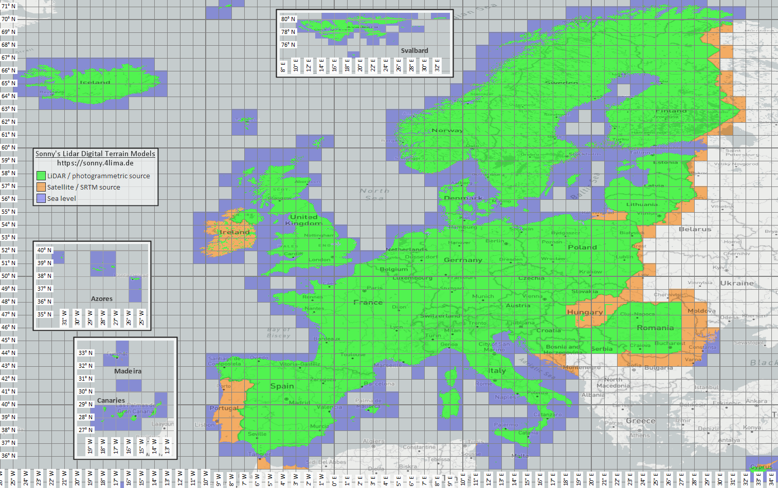
| Dane wysokościowe i terenowe | Sonny LiDAR DTM Mapa poglądowa Sonny DTM USGS SRTM OpenTopografia Copernicus Data Space | Sonny udostępnia europejskie cyfrowe modele terenu jako źródło danych o wysokości. DTM 1” i DTM 3” to siatki w sekundach łukowych, w przybliżeniu około 30 m i 90 m na równiku; DTM 20m i DTM 50m podają odstęp siatki bezpośrednio w metrach. Większa rozdzielczość wymaga więcej czasu na przechowywanie i importowanie. Użyj mapy ogólnej, aby znaleźć pasujące współrzędne/region, a następnie wybierz je na stronie źródłowej. |
| Nakładki rastrowe i mapy specjalne | Portale otwartych danych | Portale urzędowe, open data lub własne projekty GIS mogą dostarczać GeoTIFF, KML/KMZ, MBTiles lub GeoPackage. Przed importem sprawdź georeferencję i prawa użycia. |
| Style renderowania | OpenAndroMaps Podnieś | Użyj strony motywu OpenAndroMaps dla motywu Podnieś góry/wędrówki. W przypadku Android skorzystaj ze wskazówki szybkiej instalacji domyślnej aplikacji map lub pobierz Elevate.zip i zaimportuj go do ArxSilex MapTools jako motyw. |
| Licencja i aktualność | - | Źródła mogą wymagać atrybucji, rejestracji, limitów użycia lub mieć własny rytm aktualizacji. Aplikacja nie obsługuje tych dostawców i nie zastępuje ich licencji. |
Formaty
Aplikacja oddzielnie traktuje mapy, warstwy wektorowe, nakładki rastrowe, dane POI, dane wysokościowe i style map. Ten sam format pliku może mieć różne cele w zależności od jego zawartości.
| Obszar | Wsparcieed data | Ważne w użytkowaniu |
|---|---|---|
| Mapy podstawowe offline | Mapsforge .map, MBTiles .mbtiles, GeoPackage .gpkg | Pliki Mapsforge, na przykład z OpenAndroMaps, przeznaczone są do map wektorowych. MBTiles i GeoPackage służą jako kontenery kafelków lub dane katalogu map. GeoTIFF nie jest tutaj bezpośrednio renderowaną mapą bazową. |
| Warstwy wektorowe i nakładki rastrowe | GPX, GeoJSON, KML, KMZ, LOC, JSON, GeoPackage, GeoTIFF, plik kształtu ZIP | Dane wektorowe i rastrowe można przygotować jako dodatkowe warstwy. Wizualizacja GeoTIFF należy do nakładek rastrowych; DEM GeoTIFF należy do danych wysokościowych. |
| POI i wyszukiwanie offline | .poi, .db, .sqlite, .geojson, .json, .csv, .tsv, .txt, .zip | Przeszukiwalny plik POI należy zaimportować osobno. Sam plik mapy offline nie zapewnia jeszcze pełnego wyszukiwania lokalnego POI. |
| Dane wysokościowe i analiza terenu | SRTM .hgt, DEM GeoTIFF .tif/.tiff/.geotiff, ESRI ASCII Grid .asc, DTED .dt0/.dt1/.dt2, GeoPackage .gpkg, ZIP z danymi wysokościowymi | Używane do wysokości punktów, profili, cieniowania, warstwic i zasięgu widoczności. Obsługiwane dane wysokościowe GeoPackage mogą również służyć jako źródło terenu. |
| Styl mapys | Kompatybilne pliki motywu Mapsforge/Elevate ZIP | Mapa i styl mapy pozostają odrębne. Motywy zewnętrzne należy nabyć osobno i korzystać z własnej licencji. |
| Projekty i wymiana danych | Projekty ArxSilex, GPX, KML, KMZ, GeoJSON, CSV, PDF, ZIP | Formaty projektów i wymiany można przechowywać lub udostępniać w trybie offline. Udostępnione pliki opuszczają aplikację tylko dzięki Twojemu działaniu. |
Przygotowanie
Sprawdź, który region jest naprawdę potrzebny. Mniejsze, odpowiednie zestawy danych uruchamiają się szybciej i oszczędzają baterię i pamięć.
Zaimportuj plik Mapsforge .map, MBTiles lub odpowiedni GeoPackage. Następnie aktywuj go w profilu mapy.
Jeśli chcesz wyszukiwać w trybie offline, zaimportuj oprócz mapy dane POI i sprawdź kategorie, rozmiar i indeksowanie.
Importuj HGT, DEM GeoTIFF, ASC lub DTED dla profili elewacji, cieniowania wzgórz, konturów i zasięgu widoku w obszarze.
Użyj statusu offline, warstw i widoczności oraz profili map przed wejściem na obszar bez zasięgu.
Limity
Dane offline są niezawodne pod warunkiem odpowiedniego zasięgu, formatu i jakości. Niektóre funkcje celowo zależą od danych zewnętrznych lub działań użytkownika.
Aktywna zgodna mapa wektorowa Mapsforge pozwala MapTools planować odcinki po użytecznych drogach. Gdy ich brak, możliwe jest połączenie bezpośrednie lub dowolne. Utworzone i zaimportowane trasy można śledzić offline.
Dane wysokości i POI działają tylko wtedy, gdy zaimportowane pliki faktycznie obejmują dany obszar.
Mapy online Google lub OSM mogą nadal żądać kafelków od dostawców zewnętrznych. Wybierz zaimportowane mapy i dane do użytku lokalnego.
Duże mapy, pliki GeoTIFF, archiwa danych wysokościowych i bazy danych POI wymagają przechowywania, a ich import lub indeksowanie może zająć trochę czasu.
Zaimportowane mapy, warstwy wektorowe, nakładki rastrowe, dane POI, dane wysokościowe i style map można usunąć w odpowiednich obszarach danych. Dane aplikacji można również wyczyścić za pomocą Android.
ArxSilex MapTools
Import/eksport opisuje formaty wymiany bardziej szczegółowo. Uprawnienia i prywatność wyjaśniają, kiedy liczą się pliki, lokalizacja, mapy online lub osoby trzecie.
Otwórz import i eksport Otwórz uprawnienia Otwórz prywatność
W jednym miejscu
Tabela prowadzi od funkcji przez format i źródło do importu i aktywacji w MapTools. Źródła mogą wymagać rejestracji, opłaty, atrybucji lub innych warunków licencji.
| Funkcja | Wymagane dane | Odpowiednie źródła | Import do aplikacji | Aktywacja i kontrola |
|---|---|---|---|---|
| Mapa bazowa offline | Mapsforge .map · Raster-MBTiles .mbtiles · GeoPackage .gpkg | OpenAndroMaps · Mapsforge | Otwórz Dane → Centrum danych → Importuj dane. Sprawdź cel Smart Import; alternatywnie połącz folder. | Otwórz slot mapy, wybierz źródło i sprawdź zasięg. |
| POI i wyszukiwanie offline | .poi · .db · .sqlite · GeoJSON · CSV/TSV/TXT | OpenAndroMaps · własne lub urzędowe pliki POI | Otwórz Dane → Centrum danych → Importuj dane. Sprawdź cel Smart Import; alternatywnie połącz folder. | Wybierz POI w odpowiednim slocie; sprawdź kategorie, indeks i wyszukiwanie w znanym miejscu. |
| Wysokości, profile, cieniowanie, poziomice i zasięg widoczności | HGT · DEM-GeoTIFF · ASC · DTED · GeoPackage .gpkg (DEM) | Sonny LiDAR DTM · USGS SRTM · OpenTopography · Copernicus | Otwórz Dane → Centrum danych → Importuj dane. Sprawdź cel Smart Import; alternatywnie połącz folder. | Aktywuj źródło terenu i sprawdź wysokość punktu lub profil w zasięgu. |
| Planowanie tras i nawigacja offline | zgodna mapa Mapsforge .map z użytecznymi drogami | OpenAndroMaps · Mapsforge | Otwórz Dane → Centrum danych → Importuj dane. Sprawdź cel Smart Import; alternatywnie połącz folder. | Wybierz mapę Mapsforge jako źródło routingu i przetestuj Podążaj drogami na krótkim odcinku. Mapa widoczna może być inna. |
| Ślady, trasy i punkty | GPX .gpx | własne zapisy · wyeksportowane projekty · portale tras zgodnie z ich warunkami | Zaimportuj GPX przez Centrum danych, otwórz w MapTools lub udostępnij do MapTools; sprawdź projekt i wykrytą zawartość. | Pokaż zawartość w przeglądarce obiektów lub projekcie i sprawdź na mapie. |
| Warstwy GIS i wektorowe | GeoPackage · GeoJSON · Shapefile-ZIP · KML/KMZ | Geofabrik · BBBike · portale otwartych danych · urzędy · własne dane GIS | Otwórz Dane → Centrum danych → Importuj dane. Sprawdź cel Smart Import; alternatywnie połącz folder. | Aktywuj jako warstwę wektorową i sprawdź widoczność oraz układ współrzędnych. |
| Nakładki rastrowe | GeoTIFF · Raster-MBTiles · KML/KMZ | portale otwartych danych · urzędy · własne dane GIS | Otwórz Dane → Centrum danych → Importuj dane. Sprawdź cel Smart Import; alternatywnie połącz folder. | Aktywuj jako nakładkę rastrową; sprawdź położenie, krycie i skalę. |
| Style map | Mapsforge / Elevate · ZIP | OpenAndroMaps Elevate | Otwórz Dane → Centrum danych → Importuj dane. Sprawdź cel Smart Import; alternatywnie połącz folder. | Przypisz styl do zgodnej mapy Mapsforge i sprawdź wygląd oraz symbole. |
| WMS, WMTS, XYZ/TMS, WFS i OGC API Features | HTTPS · GetCapabilities · URL · Auth | dostawca usługi; sprawdź dostęp, koszt i prawa | Skonfiguruj punkt HTTPS w przeglądarce map w usługach online lub usługach obiektowych. | Przypisz zapisaną usługę do slotu lub usługi obiektowej. Sieć jest potrzebna do pobierania i FeatureInfo; to nie są pliki offline. |
| Namiary, współrzędne, siatki poszukiwań i astronomia | bez dodatkowego pliku; zależnie od narzędzia: pozycja, czujniki, czas i istniejące obiekty | MapTools i czujniki urządzenia; opcjonalnie mapa offline jako kontekst | Import nie jest potrzebny. W razie potrzeby przygotuj osobno mapę offline, obiekty lub dane wysokościowe. | Bez dodatkowego źródła. Mapa offline ułatwia orientację; analizy terenu wymagają też wysokości. |
Przed pracą bez sieci włącz globalny tryb offline i sprawdź rzeczywisty obszar: mapa, POI, aktywny teren i warstwy w prawidłowym slocie.
Aktualny przebieg pracy
MapTools może łączyć lokalne zbiory na urządzeniu Android; opcjonalny MapTools Converter pomaga w większych przygotowaniach na Windows lub Linux.
Foldery można udostępnić całej aplikacji lub projektowi przez wybór folderu Androida. MapTools pokazuje tylko pliki bezpośrednio w folderze i nigdy nie importuje ani nie aktywuje ich automatycznie.
Zgodne mapy Mapsforge i źródła terenu można połączyć bezpośrednio. Pozostałe pliki są świadomie analizowane i dodawane przez Smart Import.
Oddzielna aplikacja komputerowa sprawdza, przycina i łączy istniejące mapy, POI i dane wysokościowe oraz eksportuje pliki zgodne z MapTools. Przetwarzanie pozostaje lokalne; dane źródłowe i warunki użycia nadal pochodzą od ich dostawcy.
Astronomia i dane offline
Czasy astronomiczne są obliczane offline z miejsca, daty i strefy czasowej. Lokalne wysokości są potrzebne tylko wtedy, gdy rzeczywisty teren wpływa na widoczność lub cień.
Kalendarz Słońca/Księżyca, wschody, zachody, zmierzch, faza Księżyca oraz kierunki Słońca i Księżyca nie wymagają DEM.
Horyzont terenu, cienie powierzchniowe Słońca lub Księżyca i analiza cienia trasy wymagają odpowiednich aktywnych danych HGT, DEM GeoTIFF, ASC lub DTED.
Dane muszą obejmować miejsce lub trasę i możliwą przeszkodę w kierunku Słońca albo Księżyca. DTM opisuje teren; roślinność i budynki wymagają DSM. Rozdzielczość, wiek i luki wpływają na wynik.