클라우드가 아닌 로컬
가져온 오프라인 데이터는 앱 소유 저장소나 선택한 파일 위치에 저장됩니다. 지도, POI, 지형 또는 프로젝트에 대한 ArxSilex 클라우드 동기화가 없습니다.
오프라인
지도, POI, 고도 모델, 래스터 오버레이와 지도 스타일을 준비해 모바일 신호가 없어도 ArxSilex MapTools를 사용할 수 있게 합니다.
업데이트: 2026년 9월 8일
데이터 센터
지도, 벡터 레이어, 래스터 오버레이, 고도 데이터, 지도 스타일 및 POI 데이터를 각각 관리하세요.
가져온 오프라인 데이터는 앱 소유 저장소나 선택한 파일 위치에 저장됩니다. 지도, POI, 지형 또는 프로젝트에 대한 ArxSilex 클라우드 동기화가 없습니다.
앱은 Android 파일 선택기를 사용합니다. 의도적으로 파일을 선택합니다. ArxSilex MapTools는 전체 장치에 대한 광범위한 저장소 액세스를 요청하지 않습니다.
Smart Import는 콘텐츠별로 파일을 분석하고 기본 지도, 레이어, 래스터 오버레이, POI, 지형, 렌더링 테마 또는 프로젝트 등의 대상을 제안합니다.
온라인 지도는 외부 지도 제공업체에 타일을 요청할 수 있습니다. 이 화면의 데이터를 로컬로 유지하려면 가져온 지도, POI 및 지형 데이터를 사용하세요.
지도 사전 설정은 4개 지도 슬롯 전체, 순서 및 활성 슬롯을 저장합니다. 지도 원본, 스타일, 레이어, 지형, 오버레이, 경로 탐색 설정 및 지도 객체 표시 여부를 포함합니다. UI 프로필, 좌표, 색상, 아이콘 즐겨찾기 및 메뉴 순서는 전역 설정으로 유지됩니다.
OpenAndroMaps, OpenStreetMap, 자체 GIS 데이터, 전거 지도 또는 상업용 데이터에는 자체 라이선스 조건이 있을 수 있습니다. 앱은 외부 지도 데이터를 자동으로 묶지 않습니다.
이용 약관
ArxSilex MapTools는 이러한 용어를 의도적으로 사용합니다. 이를 통해 파일이 기본 지도, 편집 가능한 지오메트리, 이미지 오버레이 또는 고도 데이터 소스로 사용되는지 명확하게 알 수 있습니다.
| 기간 | 짧은 정의 | 예 |
|---|---|---|
| 지도 | 기본 작업 보기로 사용되는 기본 맵입니다. | OpenStreetMap, OpenAndroMaps, 오프라인 .map, MBTiles를 기본 맵으로 사용 |
| 벡터 레이어 | 지도 위의 추가 개체, 선 또는 다각형 데이터입니다. 콘텐츠는 점, 선 또는 영역으로 구성되며 개별적으로 표시하거나 평가할 수 있는 경우가 많습니다. | GPX, KML, GeoJSON, 모양, KML 다각형, GeoJSON 영역, GPX 오버레이로 추적 |
| 래스터 오버레이 | 지도 위의 지리 참조 이미지 또는 타일 데이터입니다. 완성된 이미지 표면으로 배치되며 개별 개체로 해석되지 않습니다. | GeoTIFF, MBTiles, 이미지 지도, 항공 사진, 스캔 지도, 지리 참조 계획 |
| 고도 데이터/지형 | 데이터 소스 고도 값과 지형 분석에 사용됩니다. 좁은 의미의 표시 지도는 아니지만 높이 정보를 제공합니다. | HGT, DEM GeoTIFF, ASC, DTED |
| 지도 스타일 | 벡터 지도의 렌더링 규칙. 스타일은 색상, 기호, 경로, POI, 등고선 및 기타 지도 요소를 정의합니다. | OpenAndroMaps 렌더링 테마, 테마 상승 |
| POI 데이터 | 관심 장소와 장소에 대한 데이터를 검색하고 표시합니다. | OpenAndroMaps .poi, 사용자 정의 POI 파일 |
벡터 레이어에는 개별 지오메트리가 포함됩니다. 계획 데이터, 경계, 수색 영역, 경로, 트랙, 가져온 프로젝트 정보에 유용합니다.
래스터 오버레이는 지도 위에 놓이는 완성된 이미지 표면입니다. 항공사진, 역사 지도, 스캔 이미지, 특수 지도 보기에 유용합니다. 아래 기본 지도가 보이도록 불투명도를 조정하는 경우가 많습니다.
지도, 벡터 레이어, 래스터 오버레이는 지도에 표시할 수 있습니다. 고도 데이터는 보통 지점 고도, 고도 프로필, 음영기복, 등고선, 가시범위 도구에서 사용됩니다.
소스
ArxSilex MapTools에는 타사 지도 데이터가 포함되어 있지 않습니다. 알맞은 제공자에게서 파일을 내려받고 라이선스와 형식을 확인한 뒤 앱으로 가져오세요.
| 데이터 유형 | 적합한 소스 | 참고 |
|---|---|---|
| 오프라인 기본 지도 | OpenAndroMaps 일반 지도 OpenAndroMaps 국가 및 지역 예: 독일, 유럽, USA, 남미 및 중미, 캐나다, 호주, 뉴질랜드, 오세아니아, 아시아 및 중동, 러시아, 아프리카 | OpenAndroMaps의 경우 소스 페이지에서 세계, 국가 또는 지역 지도를 선택하세요. Map/Custom라는 이름으로 Karte_Map가 포함된 ZIP 파일을 가져옵니다. POI_Normal...poi.zip를 POI로 가져옵니다. |
| POI, 레이어 및 OSM/GIS 데이터 | BBBike Extracts Geofabrik 다운로드s | BBBike 및 Geofabrik은 GeoJSON, Shapefile 또는 GeoPackage와 같은 OSM 추출 및 GIS 형식을 제공합니다. 모든 원시 형식이 바로 앱 맵인 것은 아닙니다. 지원되는 형식만 가져옵니다. Geofabrik의 경우 선택한 지역에서 GeoPackage 다운로드를 사용할 수 있는 경우 관련 앱 형식은 일반적으로 .gpkg.zip입니다. |
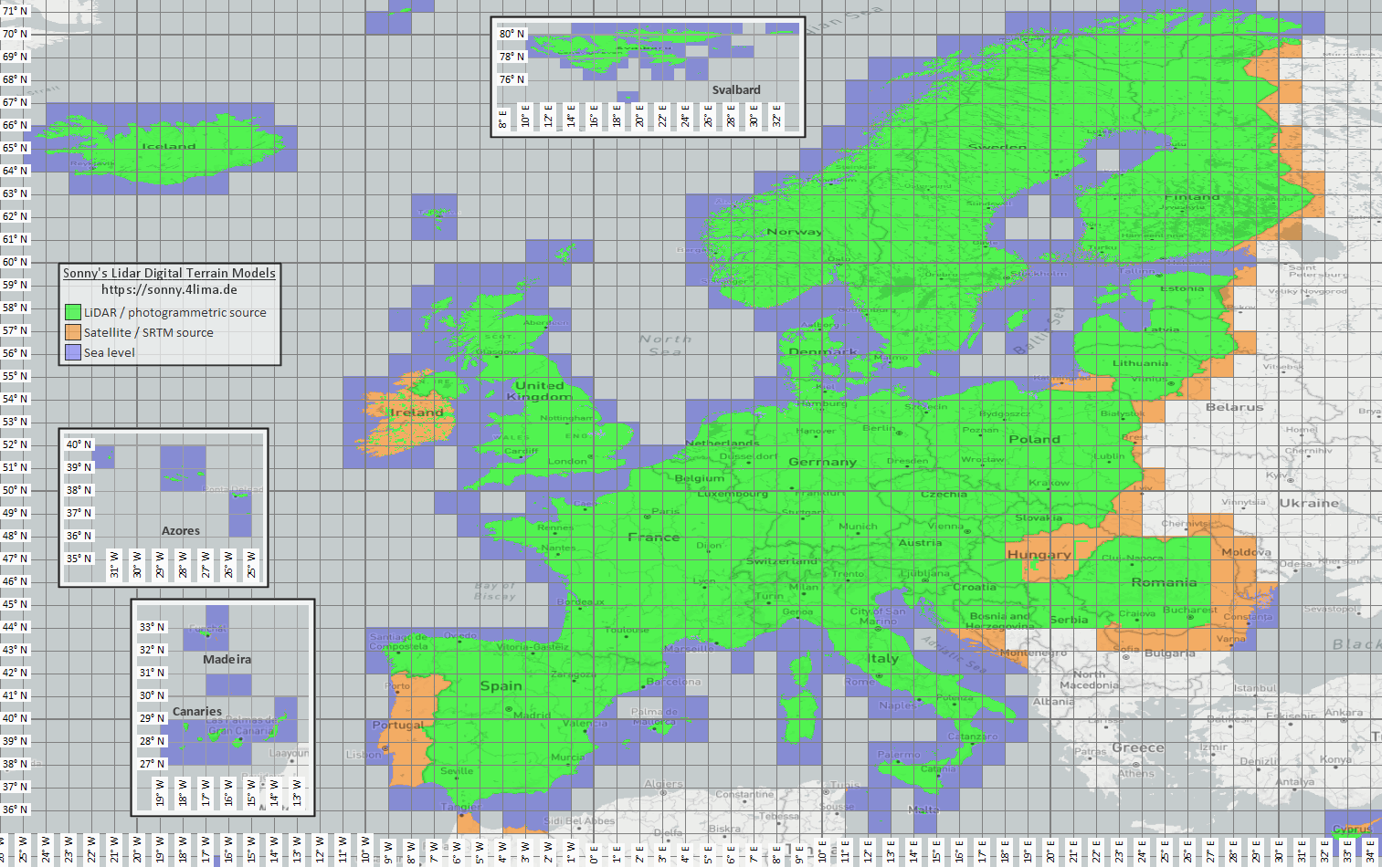
| 고도 및 지형 데이터 | Sonny LiDAR DTM Sonny DTM 개요 지도 USGS SRTM OpenTopography 코페르니쿠스 데이터 공간 | Sonny는 고도 데이터 소스로 유럽 디지털 지형 모델을 제공합니다. DTM 1" 및 DTM 3"은 호초 단위의 그리드로 적도에서 대략 30m와 90m입니다. DTM 20m 및 DTM 50m는 그리드 간격을 미터 단위로 직접 나타냅니다. 해상도가 미세할수록 더 많은 저장 공간과 가져오기 시간이 필요합니다. 개요 지도를 사용하여 일치하는 좌표/지역을 찾은 다음 소스 페이지에서 선택하세요. |
| 래스터 오버레이와 특수 지도 | 오픈 데이터 포털 | 공공 포털, 오픈 데이터 포털 또는 자체 GIS 프로젝트는 GeoTIFF, KML/KMZ, MBTiles, GeoPackage를 제공할 수 있습니다. 가져오기 전에 지오리퍼런스와 사용 권한을 확인하세요. |
| 렌더 테마 | OpenAndroMaps 상승 | Elevate Mountain/Hike 테마에 대해서는 OpenAndroMaps 테마 페이지를 사용하세요. Android에서는 기본 지도 앱의 빠른 설치 힌트를 사용하거나 Elevate.zip를 다운로드하여 ArxSilex MapTools에 테마로 가져옵니다. |
| 라이선스와 최신성 | - | 데이터 소스는 출처 표시, 등록, 사용 제한 또는 자체 업데이트 주기를 요구할 수 있습니다. 앱은 이러한 제공자를 운영하지 않으며 라이선스 문서를 대체하지 않습니다. |
형식
이 앱은 지도, 벡터 레이어, 래스터 오버레이, POI 데이터, 고도 데이터 및 지도 스타일을 별도로 처리합니다. 동일한 파일 형식이라도 내용에 따라 대상이 다를 수 있습니다.
| 영역 | 지원ed data | 사용에 중요한 |
|---|---|---|
| 오프라인 기본 지도 | Mapsforge .map, MBTiles .mbtiles, GeoPackage .gpkg | 예를 들어 OpenAndroMaps의 Mapsforge 파일은 벡터 맵용입니다. MBTiles 및 GeoPackage는 타일 컨테이너 또는 지도 카탈로그 데이터로 사용됩니다. GeoTIFF는 여기서 직접 렌더링 가능한 기본 맵이 아닙니다. |
| 벡터 레이어 및 래스터 오버레이 | GPX, GeoJSON, KML, KMZ, LOC, JSON, GeoPackage, GeoTIFF, Shapefile ZIP | 벡터 및 래스터 데이터를 추가 레이어로 준비할 수 있습니다. Visual GeoTIFF는 래스터 오버레이에 속합니다. DEM GeoTIFF는 고도 데이터에 속합니다. |
| POI 및 오프라인 검색 | .poi, .db, .sqlite, .geojson, .json, .csv, .tsv, .txt, .zip | 검색 가능한 POI는 별도로 가져와야 합니다. 오프라인 지도 파일만으로는 아직 완전한 로컬 POI 검색을 제공하지 않습니다. |
| 고도 데이터 및 지형 분석 | SRTM .hgt, DEM GeoTIFF .tif/.tiff/.geotiff, ESRI ASCII Grid .asc, DTED .dt0/.dt1/.dt2, GeoPackage .gpkg, 고도 데이터 ZIP | 지점 고도, 경로 고도 프로필, 음영기복, 등고선과 가시권에 사용됩니다. 지원되는 GeoPackage 고도 데이터도 지형 원본으로 사용할 수 있습니다. |
| 지도 스타일s | 호환되는 Mapsforge/Elevate와 유사한 테마 ZIP 파일 | 지도와 지도 스타일은 별개로 유지됩니다. 외부 테마는 별도로 구입해야 하며 자체 라이선스를 따라야 합니다. |
| 프로젝트 및 데이터 교환 | ArxSilex 프로젝트, GPX, KML, KMZ, GeoJSON, CSV, PDF, ZIP | 프로젝트 및 교환 형식을 오프라인으로 저장하거나 공유할 수 있습니다. 공유된 파일은 사용자의 작업을 통해서만 앱에서 나갑니다. |
준비
정말 필요한 지역이 어디인지 확인해보세요. 더 작고 적합한 데이터 세트는 더 빠르게 시작되고 배터리와 스토리지를 절약합니다.
Mapsforge .map 파일, MBTiles 또는 적합한 GeoPackage를 가져옵니다. 그런 다음 지도 프리셋에서 활성화하세요.
오프라인 검색을 원할 경우 지도 외에 POI 데이터를 가져와서 카테고리, 크기, 인덱싱을 확인하세요.
해당 지역의 고도 프로필, 음영기복도, 등고선 및 시야 범위에 대해 HGT, DEM GeoTIFF, ASC 또는 DTED를 가져옵니다.
적용 범위가 없는 지역에 들어가기 전에 오프라인 상태, 레이어 및 가시성, 지도 프리셋을 사용하세요.
한도
범위, 형식, 품질이 적합하다면 오프라인 데이터는 신뢰할 수 있습니다. 일부 기능은 외부 데이터나 사용자 작업에 의도적으로 의존합니다.
활성화된 호환 Mapsforge 벡터 지도가 있으면 MapTools는 사용할 수 있는 길을 따라 구간을 계획할 수 있습니다. 적합한 길이 없으면 직선 또는 자유 연결을 사용할 수 있습니다. 생성하거나 가져온 경로는 오프라인으로 따라갈 수 있습니다.
고도 데이터 및 POI는 가져온 파일이 실제로 해당 영역을 포함하는 경우에만 작동합니다.
Google 또는 OSM 온라인 지도는 여전히 외부 공급자에게 타일을 요청할 수 있습니다. 로컬에서 사용할 수 있도록 가져온 지도와 데이터를 선택하세요.
대형 지도, GeoTIFF, 고도 데이터 아카이브 및 POI 데이터베이스에는 저장 공간이 필요하며 가져오거나 색인을 생성하는 데 시간이 걸릴 수 있습니다.
가져온 지도, 벡터 레이어, 래스터 오버레이, POI 데이터, 고도 데이터 및 지도 스타일을 관련 데이터 영역에서 제거할 수 있습니다. Android를 통해서도 앱 데이터를 삭제할 수 있습니다.
ArxSilex MapTools
가져오기/내보내기에서는 교환 형식에 대해 자세히 설명합니다. 권한 및 개인 정보 보호는 파일, 위치, 온라인 지도 또는 제3자가 중요한 경우를 설명합니다.
한눈에 보기
이 표는 사용할 기능부터 파일 형식, 제공처, MapTools 가져오기와 활성화까지 연결합니다. 제공처에 따라 등록, 결제, 출처 표시 또는 추가 라이선스 조건이 필요할 수 있습니다.
| 기능 | 필요한 데이터 | 적합한 제공처 | 앱으로 가져오기 | 활성화 및 확인 |
|---|---|---|---|---|
| 오프라인 기본 지도 | Mapsforge .map · Raster-MBTiles .mbtiles · GeoPackage .gpkg | OpenAndroMaps · Mapsforge | 데이터 → 데이터 센터 → 데이터 가져오기를 엽니다. Smart Import 대상을 확인하거나 데이터 폴더를 연결합니다. | 지도 슬롯을 열고 소스를 선택한 뒤 범위를 확인합니다. |
| POI 및 오프라인 검색 | .poi · .db · .sqlite · GeoJSON · CSV/TSV/TXT | OpenAndroMaps · 자체 또는 공공 POI 파일 | 데이터 → 데이터 센터 → 데이터 가져오기를 엽니다. Smart Import 대상을 확인하거나 데이터 폴더를 연결합니다. | 적절한 슬롯에서 POI를 선택하고 알려진 위치에서 범주, 색인 및 검색을 확인합니다. |
| 고도, 프로필, 음영, 등고선 및 가시 범위 | HGT · DEM-GeoTIFF · ASC · DTED · GeoPackage .gpkg (DEM) | Sonny LiDAR DTM · USGS SRTM · OpenTopography · Copernicus | 데이터 → 데이터 센터 → 데이터 가져오기를 엽니다. Smart Import 대상을 확인하거나 데이터 폴더를 연결합니다. | 지형 소스를 활성화하고 범위 안에서 지점 고도 또는 프로필을 확인합니다. |
| 오프라인 경로 계획 및 내비게이션 | 사용 가능한 길 데이터가 있는 호환 Mapsforge .map | OpenAndroMaps · Mapsforge | 데이터 → 데이터 센터 → 데이터 가져오기를 엽니다. Smart Import 대상을 확인하거나 데이터 폴더를 연결합니다. | Mapsforge 지도를 라우팅 소스로 선택하고 짧은 구간에서 길 따라가기를 시험합니다. 표시 지도와 라우팅 소스는 달라도 됩니다. |
| 트랙, 경로 및 웨이포인트 | GPX .gpx | 자체 기록 · 내보낸 프로젝트 · 이용 조건에 따른 경로 포털 | 데이터 센터에서 GPX를 가져오거나 MapTools로 열기/공유합니다. 대상 프로젝트와 감지된 내용을 확인합니다. | 객체 브라우저 또는 프로젝트에서 표시하고 지도에서 확인합니다. |
| GIS 및 벡터 레이어 | GeoPackage · GeoJSON · Shapefile-ZIP · KML/KMZ | Geofabrik · BBBike · 오픈 데이터 포털 · 기관 · 자체 GIS 데이터 | 데이터 → 데이터 센터 → 데이터 가져오기를 엽니다. Smart Import 대상을 확인하거나 데이터 폴더를 연결합니다. | 원하는 슬롯에서 벡터 레이어로 활성화하고 표시 및 좌표 기준을 확인합니다. |
| 래스터 오버레이 | GeoTIFF · Raster-MBTiles · KML/KMZ | 오픈 데이터 포털 · 기관 · 자체 GIS 데이터 | 데이터 → 데이터 센터 → 데이터 가져오기를 엽니다. Smart Import 대상을 확인하거나 데이터 폴더를 연결합니다. | 래스터 오버레이로 활성화하고 위치, 불투명도 및 축척을 확인합니다. |
| 지도 스타일 | Mapsforge / Elevate · ZIP | OpenAndroMaps Elevate | 데이터 → 데이터 센터 → 데이터 가져오기를 엽니다. Smart Import 대상을 확인하거나 데이터 폴더를 연결합니다. | 호환 Mapsforge 지도에 스타일을 지정하고 렌더링과 기호를 확인합니다. |
| WMS, WMTS, XYZ/TMS, WFS 및 OGC API Features | HTTPS · GetCapabilities · URL · Auth | 해당 서비스 제공자에서 접근, 비용 및 사용 권한 확인 | 지도 브라우저의 온라인 지도 서비스 또는 객체 서비스에서 HTTPS 엔드포인트를 설정합니다. | 저장한 서비스를 슬롯 또는 객체 서비스에 지정합니다. 조회와 FeatureInfo에는 네트워크가 필요하며 오프라인 파일이 아닙니다. |
| 방위, 좌표, 수색 격자 및 천문 | 추가 파일 없음. 도구에 따라 위치, 기기 센서, 시간 및 기존 지도 객체 사용 | MapTools와 기기 센서. 지도 맥락에는 오프라인 기본 지도 선택 사용 | 가져올 데이터가 없습니다. 필요한 경우 오프라인 지도, 객체 또는 고도 데이터를 별도로 준비합니다. | 추가 소스는 없습니다. 오프라인 지도는 방향 파악을 돕고 지형 분석에는 고도 데이터도 필요합니다. |
네트워크 없이 사용하기 전에 전역 오프라인 모드를 켜고 실제 지역에서 지도, POI, 지형 및 올바른 슬롯의 레이어를 확인하세요.
현재 작업 흐름
MapTools는 Android 기기의 로컬 모음을 연결할 수 있으며, 선택 사항인 MapTools Converter는 Windows 또는 Linux에서 큰 준비 작업을 돕습니다.
Android 폴더 선택기로 앱 전체 또는 프로젝트별 접근을 허용할 수 있습니다. MapTools는 바로 포함된 파일만 표시하며 자동으로 가져오거나 활성화하지 않습니다.
호환 Mapsforge 지도와 지형 원본은 직접 연결할 수 있습니다. 다른 파일은 확인 후 Smart Import로 추가합니다.
별도 데스크톱 앱은 기존 지도, POI와 고도 데이터를 검사하고 자르거나 결합하여 MapTools 호환 파일로 내보냅니다. 처리는 로컬에서 이루어지며 원본 데이터와 이용 조건은 해당 제공자가 정합니다.
천문 기능과 오프라인 데이터
천문 시각은 장소, 날짜, 시간대로 오프라인 계산됩니다. 실제 지형을 가시성 또는 그림자 결과에 포함할 때만 로컬 고도원이 필요합니다.
태양/달 달력, 출몰, 박명, 달 위상, 태양과 달 방향은 DEM이 필요 없습니다.
지형 지평선, 태양 또는 달의 면적 그림자, 경로 그늘 분석에는 활성화된 적합한 HGT, DEM GeoTIFF, ASC 또는 DTED가 필요합니다.
데이터는 장소나 경로와 함께 태양·달 방향의 차폐 후보도 덮어야 합니다. DTM은 지형을, 식생과 건물은 DSM을 요구합니다. 해상도, 오래된 정도, 누락이 결과에 영향을 줍니다.