Místní, ne cloudové
Importovaná offline data se ukládají do úložiště vlastněného aplikací nebo do umístění souboru, které si vyberete. Neexistuje žádná cloudová synchronizace ArxSilex pro mapy, POI, terén nebo projekty.
Offline
Připravte mapy, POI, výškové modely, rastrové překryvy a styly map, aby ArxSilex MapTools fungoval i bez mobilního signálu.
Aktualizováno: 8. září 2026
Datové centrum
Spravujte samostatně mapy, vektorové vrstvy, rastrové překryvy, výšková data, mapové styly a data POI.
Importovaná offline data se ukládají do úložiště vlastněného aplikací nebo do umístění souboru, které si vyberete. Neexistuje žádná cloudová synchronizace ArxSilex pro mapy, POI, terén nebo projekty.
Aplikace používá výběr souborů Android. Soubory vybíráte záměrně; ArxSilex MapTools nepožaduje široký přístup k úložišti k celému zařízení.
Smart Import analyzuje soubory podle obsahu a navrhuje cíl: základní mapu, vrstvu, rastrové překrytí, POI, terén, téma vykreslení nebo projekt.
Online mapy mohou požadovat dlaždice od externích poskytovatelů map. Pokud chcete, aby toto zobrazení zůstalo místní, použijte importované mapy, POI a výšková data.
Předvolba mapy ukládá všechny čtyři pozice mapy, jejich pořadí a aktivní pozici, včetně zdrojů map, stylů, vrstev, terénu, překryvů, nastavení výpočtu tras a viditelnosti mapových objektů. Profil rozhraní, souřadnice, barvy, oblíbené ikony a pořadí nabídek zůstávají globálními nastaveními.
OpenAndroMaps, OpenStreetMap, vaše vlastní data GIS, mapy autorit nebo komerční data mohou mít své vlastní licenční podmínky. Aplikace automaticky nesdružuje externí mapová data.
Podmínky používání
ArxSilex MapTools používá tyto výrazy záměrně. Jasně z nich vyplývá, zda se soubor používá jako podkladová mapa, upravitelná geometrie, překryvný obrázek nebo zdroj dat o nadmořské výšce.
| Termín | Krátká definice | Příklady |
|---|---|---|
| Mapy | Základní mapy používané jako hlavní pracovní pohled. | OpenStreetMap, OpenAndroMaps, offline .map, MBTiles jako základní mapa |
| Vektorové vrstvy | Další údaje o objektu, linii nebo polygonu nad mapou. Obsah se skládá z bodů, čar nebo ploch a často může být zobrazen nebo vyhodnocen individuálně. | GPX, KML, GeoJSON, Tvary, KML polygony, GeoJSON oblasti, GPX stopy jako překryvy |
| Rastrové překryvy | Georeferencovaná data obrázku nebo dlaždic nad mapou. Jsou umístěny jako hotový obrazový povrch a nejsou interpretovány jako jednotlivé objekty. | GeoTIFF, MBTiles, obrazové mapy, letecké snímky, naskenované mapy, georeferenční plány |
| Údaje o nadmořské výšce / terén | Zdroje dat pro výškové hodnoty a analýzu terénu. Nejsou viditelnou mapou v úzkém smyslu, ale poskytují informace o výšce. | HGT, DEM GeoTIFF, ASC, DTED |
| Styl mapy | Pravidla vykreslování vektorových map. Styl definuje barvy, symboly, cesty, POI, vrstevnice a další prvky mapy. | Téma vykreslení OpenAndroMaps, motiv Elevate |
| Data POI | Vyhledávejte a zobrazujte data míst a bodů zájmu. | OpenAndroMaps .poi, vlastní soubory POI |
Vektorové vrstvy obsahují jednotlivé geometrie. Hodí se pro plánovací data, hranice, vyhledávací oblasti, trasy, stopy a importované informace projektu.
Rastrové překryvy jsou hotové obrazové plochy nad mapou. Hodí se pro letecké snímky, historické mapy, skeny nebo speciální mapové pohledy. Průhlednost se často upravuje, aby zůstala viditelná podkladová mapa.
Mapy, vektorové vrstvy a rastrové překryvy lze zobrazit na mapě. Výšková data obvykle používají nástroje: výška bodu, výškový profil, stínování, vrstevnice a dohlednost.
Zdroje
ArxSilex MapTools nedodává mapová data třetích stran. Stáhněte soubory od vhodného poskytovatele, ověřte licenci a formát a poté je vědomě importujte do aplikace.
| Typ dat | Vhodné zdroje | Poznámky |
|---|---|---|
| Offline podkladové mapy | Obecné mapy OpenAndroMaps Země a oblasti OpenAndroMaps Příklady: Německo, Evropa, USA, Jižní a Střední Amerika, Kanada, Austrálie, Nový Zéland, Oceánie, Asie a Střední východ, Rusko, Afrika | Pro OpenAndroMaps vyberte na zdrojové stránce mapu světa, země nebo regionu. Importujte soubory ZIP se Karte_Map v názvu jako Map/Custom; import POI_Normal...poi.zip jako POI. |
| POI, vrstvy a data OSM/GIS | BBBike Extracts Geofabrik Staženís | BBBike a Geofabrik poskytují OSM extrakty a GIS formáty jako GeoJSON, Shapefile nebo GeoPackage. Ne každý raw formát je přímo mapou aplikace; importovat pouze podporované formáty. Pro Geofabrik je relevantní formát aplikace obvykle .gpkg.zip, když je pro vybranou oblast k dispozici stažení GeoPackage. |
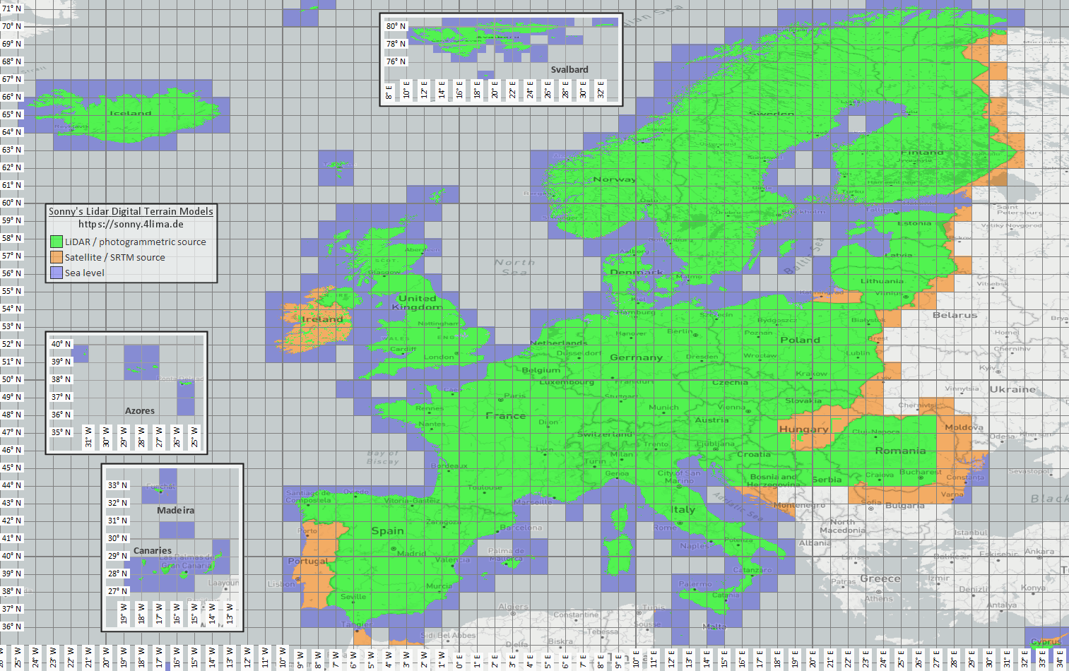
| Výšková a terénní data | sonny LiDAR DTM sonny DTM přehledová mapa USGS SRTM OopenTopography Copernicus Data Space | Sonny poskytuje evropské digitální modely terénu jako zdroj dat o nadmořské výšce. DTM 1" a DTM 3" jsou mřížky v obloukových sekundách, zhruba 30 ma 90 m na rovníku; DTM 20m a DTM 50m uvádějí rozteč mřížky přímo v metrech. Jemnější rozlišení vyžaduje delší dobu ukládání a importu. Pomocí orientační mapy vyhledejte odpovídající souřadnice/oblast a poté ji vyberte na zdrojové stránce. |
| Rastrové překryvy a speciální mapy | Portály s otevřenými daty | Úřední portály, open data nebo vlastní GIS projekty mohou poskytovat GeoTIFF, KML/KMZ, MBTiles nebo GeoPackage. Před importem zkontrolujte georeferenci a práva užití. |
| Renderovací témata | OopenAndroMaps Elevate | Použijte stránku tématu OpenAndroMaps pro téma Elevate mountain/hike. Na Android použijte nápovědu pro rychlou instalaci pro výchozí aplikaci map nebo si stáhněte Elevate.zip a importujte jej do ArxSilex MapTools jako motiv. |
| Licence a aktuálnost | - | Zdroje mohou vyžadovat uvedení autorství, registraci, limity použití nebo mít vlastní aktualizace. Aplikace tyto poskytovatele neprovozuje a nenahrazuje jejich licence. |
Formáty
Aplikace zpracovává mapy, vektorové vrstvy, rastrové překryvy, data POI, data nadmořské výšky a styly map samostatně. Stejný formát souboru může mít různé cíle v závislosti na jeho obsahu.
| Plocha | Podporaed data | Důležité pro použití |
|---|---|---|
| Offline základní mapy | Mapsforge .map, MBTiles .mbtiles, GeoPackage .gpkg | Pro vektorové mapy jsou určeny soubory Mapsforge, například z OpenAndroMaps. MBTiles a GeoPackage se používají jako kontejnery dlaždic nebo data mapového katalogu. GeoTIFF zde není přímo renderovatelná základní mapa. |
| Vektorové vrstvy a rastrové překryvy | GPX, GeoJSON, KML, KMZ, LOC, JSON, GeoPackage, GeoTIFF, Shapefile ZIP | Vektorová a rastrová data lze připravit jako další vrstvy. Visual GeoTIFF patří mezi rastrové překryvy; DEM GeoTIFF patří k údajům o nadmořské výšce. |
| POI a offline vyhledávání | .poi, .db, .sqlite, .geojson, .json, .csv, .tsv, .txt, .zip | Prohledávatelný POI je nutné importovat samostatně. Offline mapový soubor sám o sobě zatím neposkytuje úplné místní vyhledávání POI. |
| Výškové údaje a analýza terénu | SRTM .hgt, DEM GeoTIFF .tif/.tiff/.geotiff, ESRI ASCII Grid .asc, DTED .dt0/.dt1/.dt2, GeoPackage .gpkg, ZIP s výškovými daty | Používá se pro výšku bodu, výškové profily, stínování, vrstevnice a dohlednost. Podporovaná výšková data GeoPackage lze také použít jako zdroj terénu. |
| Styl mapys | Kompatibilní soubory Mapsforge/Elevate-like ZIP | Mapa a styl mapy zůstávají oddělené. Externí motivy je nutné získat samostatně a řídit se vlastní licencí. |
| Projekty a výměna dat | Projekty ArxSilex, GPX, KML, KMZ, GeoJSON, CSV, PDF, ZIP | Projektové a výměnné formáty lze ukládat nebo sdílet offline. Sdílené soubory opustí aplikaci pouze prostřednictvím vaší akce. |
Příprava
Zkontrolujte, který region je skutečně potřeba. Menší vhodné datové sady se spouštějí rychleji a šetří baterii a úložiště.
Importujte soubor Mapsforge .map, MBTiles nebo vhodný GeoPackage. Poté jej aktivujte v mapové předvolbě.
Pokud chcete offline vyhledávání, importujte kromě mapy i data POI a zkontrolujte kategorie, velikost a indexování.
Importujte HGT, DEM GeoTIFF, ASC nebo DTED pro výškové profily, stínění kopce, vrstevnice a rozsah pohledu v oblasti.
Před vstupem do oblasti bez pokrytí použijte offline stav, Vrstvy a viditelnost a mapové předvolby.
Limity
Offline data jsou spolehlivá, pokud odpovídá pokrytí, formát a kvalita. Některé funkce záměrně závisí na externích datech nebo akci uživatele.
S aktivní kompatibilní vektorovou mapou Mapsforge může MapTools plánovat úseky po použitelných cestách. Pokud vhodná data chybí, zůstává možné přímé nebo volné spojení. Vytvořené či importované trasy lze sledovat offline.
Údaje o nadmořské výšce a POI fungují pouze tam, kde importované soubory skutečně pokrývají oblast.
Online mapy Google nebo OSM mohou stále požadovat dlaždice od externích poskytovatelů. Vyberte importované mapy a data pro místní použití.
Velké mapy, GeoTIFFy, výškové datové archivy a databáze POI potřebují úložiště a jejich import nebo indexování může chvíli trvat.
Importované mapy, vektorové vrstvy, rastrové překryvy, data POI, data nadmořské výšky a styly map lze odstranit v příslušných oblastech dat. Data aplikace lze také vymazat pomocí Android.
ArxSilex MapTools
Import/export popisuje formáty výměny podrobněji. Oprávnění a soukromí vysvětlují, kdy na souborech, umístění, online mapách nebo třetích stranách záleží.
Ootevřít import a export Otevřít oprávnění Ootevřít soukromí
Na jednom místě
Tabulka propojuje funkci s formátem, zdrojem, importem a aktivací v MapTools. Zdroje mohou vyžadovat registraci, platbu, uvedení autora nebo další licenční podmínky.
| Funkce | Potřebná data | Vhodné zdroje | Import do aplikace | Aktivace a kontrola |
|---|---|---|---|---|
| Offline základní mapa | Mapsforge .map · Raster-MBTiles .mbtiles · GeoPackage .gpkg | OpenAndroMaps · Mapsforge | Otevřete Data → Datové centrum → Importovat data. Ověřte cíl Smart Import; případně připojte složku. | Otevřete mapový slot, vyberte zdroj a otestujte pokrytí. |
| POI a offline vyhledávání | .poi · .db · .sqlite · GeoJSON · CSV/TSV/TXT | OpenAndroMaps · vlastní nebo úřední soubory POI | Otevřete Data → Datové centrum → Importovat data. Ověřte cíl Smart Import; případně připojte složku. | Vyberte POI ve vhodném slotu; otestujte kategorie, index a hledání na známém místě. |
| Výšky, profily, stínování, vrstevnice a dohlednost | HGT · DEM-GeoTIFF · ASC · DTED · GeoPackage .gpkg (DEM) | Sonny LiDAR DTM · USGS SRTM · OpenTopography · Copernicus | Otevřete Data → Datové centrum → Importovat data. Ověřte cíl Smart Import; případně připojte složku. | Aktivujte zdroj terénu a otestujte výšku bodu nebo profil v pokrytí. |
| Offline plánování tras a navigace | kompatibilní mapa Mapsforge .map s použitelnými cestami | OpenAndroMaps · Mapsforge | Otevřete Data → Datové centrum → Importovat data. Ověřte cíl Smart Import; případně připojte složku. | Vyberte mapu Mapsforge jako zdroj routingu a na krátkém úseku otestujte Sledovat cesty. Zobrazená mapa může být jiná. |
| Stopy, trasy a body | GPX .gpx | vlastní záznamy · exportované projekty · portály tras podle jejich podmínek | Importujte GPX přes Datové centrum, otevřete v MapTools nebo sdílejte do MapTools; ověřte projekt a obsah. | Zobrazte obsah v prohlížeči objektů nebo projektu a ověřte jej na mapě. |
| GIS a vektorové vrstvy | GeoPackage · GeoJSON · Shapefile-ZIP · KML/KMZ | Geofabrik · BBBike · portály otevřených dat · úřady · vlastní GIS data | Otevřete Data → Datové centrum → Importovat data. Ověřte cíl Smart Import; případně připojte složku. | Aktivujte jako vektorovou vrstvu a ověřte viditelnost i souřadnicový systém. |
| Rastrové překryvy | GeoTIFF · Raster-MBTiles · KML/KMZ | portály otevřených dat · úřady · vlastní GIS data | Otevřete Data → Datové centrum → Importovat data. Ověřte cíl Smart Import; případně připojte složku. | Aktivujte jako rastrový překryv; ověřte polohu, průhlednost a měřítko. |
| Mapové styly | Mapsforge / Elevate · ZIP | OpenAndroMaps Elevate | Otevřete Data → Datové centrum → Importovat data. Ověřte cíl Smart Import; případně připojte složku. | Přiřaďte styl kompatibilní mapě Mapsforge a ověřte vzhled a symboly. |
| WMS, WMTS, XYZ/TMS, WFS a OGC API Features | HTTPS · GetCapabilities · URL · Auth | poskytovatel služby; ověřte přístup, cenu a práva | Nastavte HTTPS endpoint v prohlížeči map mezi online službami nebo objektovými službami. | Přiřaďte uloženou službu slotu nebo objektové službě. Pro načtení a FeatureInfo je nutná síť; nejde o offline soubory. |
| Azimuty, souřadnice, pátrací rastry a astronomie | žádný další soubor; podle nástroje poloha, senzory, čas a existující mapové objekty | MapTools a senzory zařízení; volitelně offline mapa pro kontext | Import není nutný. Podle potřeby připravte zvlášť offline mapu, objekty nebo výšková data. | Bez dalšího zdroje. Offline mapa zlepšuje orientaci; analýza terénu potřebuje výšková data. |
Před použitím bez sítě zapněte globální offline režim a otestujte skutečnou oblast: mapu, POI, terén a vrstvy ve správném slotu.
Současný postup
MapTools může propojit místní sbírky v zařízení Android; volitelný MapTools Converter pomáhá s větší přípravou ve Windows nebo Linuxu.
Složky lze povolit pro celou aplikaci nebo pro projekt pomocí výběru složky Androidu. MapTools zobrazuje jen přímo obsažené soubory a nikdy nic automaticky neimportuje ani neaktivuje.
Kompatibilní mapy Mapsforge a zdroje terénu lze propojit přímo. Ostatní soubory se vědomě analyzují a přidávají přes Smart Import.
Samostatná desktopová aplikace kontroluje, ořezává a kombinuje existující mapy, POI a výšková data a exportuje soubory kompatibilní s MapTools. Zpracování zůstává místní; zdrojová data a podmínky použití nadále určuje jejich poskytovatel.
Astronomie a offline data
Astronomické časy se počítají offline z místa, data a časového pásma. Místní výškový zdroj je nutný jen při zahrnutí skutečného terénu do viditelnosti nebo stínu.
Kalendář Slunce/Měsíce, východy, západy, soumrak, fáze Měsíce a směry Slunce a Měsíce nevyžadují DEM.
Terénní horizont, plošné stíny Slunce či Měsíce a analýza stínu trasy vyžadují vhodná aktivní data HGT, DEM GeoTIFF, ASC nebo DTED.
Data musí pokrýt místo či trasu i možnou překážku směrem ke Slunci nebo Měsíci. DTM popisuje terén; vegetace a budovy vyžadují DSM. Výsledek ovlivňuje rozlišení, stáří a mezery.